弗雷斯诺
| 弗雷斯诺 Fresno | |||
|---|---|---|---|
| 市 | |||
| 弗雷斯诺市 | |||
| |||
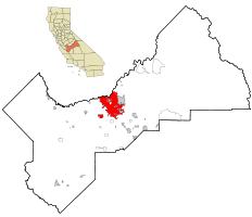
 在州内和县内的位置 | |||
| 坐标:36°46′54″N 119°47′32″W / 36.7817°N 119.7922°W | |||
| 国家 | |||
| 州 | |||
| 郡 | 弗雷斯诺 | ||
| 地区 | 圣华金谷 | ||
| 建立 | 1872年 | ||
| 法人地位 | 1885年10月12日[1] | ||
| 政府 | |||
| • 类型 | 市长-议会制政府 | ||
| • 市长 | Ashley Swearengin[2] | ||
| • 市经理 | Bruce Rudd[3] | ||
| • 市议会[4] | Esmeralda Soria Steve Brandau Oliver Baines III Paul Caprioglio Sal Quintero Lee Brand Clint Olivier | ||
| 面积[5] | |||
| • 市 | 112.308 平方英里(290.877 平方公里) | ||
| • 陆地 | 111.957 平方英里(289.967 平方公里) | ||
| • 水域 | 0.351 平方英里(0.91 平方公里) 0.31% | ||
| 海拔[6] | 308 英尺(94 米) | ||
| 人口(2011年)[7] | |||
| • 市 | 494,665人 | ||
| • 估计(2013)[7] | 509,924 | ||
| • 排名 | 县内第一 州内第五 国内第34 | ||
| • 密度 | 4,405人/平方英里(1,701人/平方公里) | ||
| • 都会区 | 1,081,315 | ||
| 居民称谓 | Fresnan | ||
| 时区 | 太平洋时间(UTC-8) | ||
| • 夏时制 | PDT(UTC-7) | ||
| 邮编[8] | 93650, 93701–93712、93714–93718、93720–93730、93737、93740、93741、93744、93745、93747、93750、93755、93760、93761、93764、93765、93771–79、93786、93790–94、93844、93888 | ||
| 电话区号 | 559 | ||
| FIPS编码 | 06-27000[9] | ||
| GNIS特征ID | 277606、2410546 | ||
| 网站 | www | ||
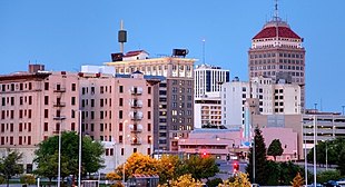
弗雷斯诺(英语:Fresno),美国华裔普遍简称佛市,是美国加利福尼亚州的第五大城市,弗雷斯诺县县治。弗雷斯诺位建于广阔的加州中央谷地之上[10],是弗雷斯诺都会区的文化和经济中心。
地理
根据美国人口普查局的资料,弗雷斯诺总面积为271.4平方千米,水域面积为1.1平方千平,占总面积0.42%。弗雷斯诺位于36°46′54″N 119°47′32″W / 36.78167°N 119.79222°W,接近加利福尼亚州的中心,与其他主要娱乐地区和城市中心距离都不远。该市位于约塞米蒂国家公园以南约100千米,是距离该公园最近的主要城市;此外,该市距金斯坎宁国家公园100千米;距红杉国家公园120千米。
弗雷斯诺作为加利福尼亚州41号和99号公路的交汇点,是通往洛杉矶的主要门户,该市也是加州180号公路通往红杉和金斯坎宁国家公园的入口。
气候
弗雷斯诺属地中海气候,冬季温和,夏季炎热干旱。[11]该区夏季阳光充沛,7月日间日照时间平均占96%,为全年最高;12月则只占42%,为全年最低。全年的大部分时间空气沿中央谷地南移,故该区风向以西北为主,1月和2月则有较多东南风。[12]
根据1991至2020年在佛雷斯诺优胜美地国际机场的数据,日最低气温低于或等于0 °C(32 °F)的平均日数为11天;日最高气温达30 °C(86 °F)的日数年均有136天,40 °C(104 °F)以上的有14天。[13]最冷月(12月)均温8.6 °C(47.5 °F),极端最低气温−8 °C(17 °F)(1913年1月6日)。[13]最热月(7月)均温28.6 °C(83.5 °F),极端最高气温46 °C(115 °F)(1905年7月8日)。[13]年均降水量约279毫米(10.99英寸),年极端最少降水量为76毫米(3.01英寸)(2013年),最多为549毫米(21.61英寸)(1983年);12月至3月占全年大约70%的降水量。[13]无霜期平均有324天(1月24日至12月14日)。[13]
| 加州佛雷斯诺优胜美地国际机场/KFAT(1991–2020年正常值,1881年至今极端数据) | |||||||||||||
|---|---|---|---|---|---|---|---|---|---|---|---|---|---|
| 月份 | 1月 | 2月 | 3月 | 4月 | 5月 | 6月 | 7月 | 8月 | 9月 | 10月 | 11月 | 12月 | 全年 |
| 历史最高温 °C(°F) | 26 (78) |
29 (84) |
33 (91) |
38 (101) |
43 (110) |
44 (112) |
46 (115) |
45 (113) |
46 (114) |
39 (102) |
32 (90) |
25 (77) |
46 (115) |
| 平均最高温 °C(°F) | 20.1 (68.1) |
23.2 (73.7) |
27.7 (81.9) |
32.7 (90.8) |
37.2 (99.0) |
41.1 (105.9) |
42.1 (107.7) |
41.7 (107.1) |
39.5 (103.1) |
34.0 (93.2) |
26.4 (79.6) |
19.7 (67.4) |
42.9 (109.2) |
| 平均高温 °C(°F) | 13.0 (55.4) |
16.3 (61.3) |
19.7 (67.5) |
23.2 (73.7) |
28.2 (82.7) |
33.0 (91.4) |
36.5 (97.7) |
35.8 (96.5) |
32.6 (90.7) |
25.9 (78.7) |
18.3 (64.9) |
12.9 (55.3) |
24.6 (76.3) |
| 平均低温 °C(°F) | 4.8 (40.6) |
6.3 (43.3) |
8.5 (47.3) |
10.5 (50.9) |
14.2 (57.6) |
17.7 (63.9) |
20.7 (69.3) |
19.9 (67.9) |
17.4 (63.4) |
12.6 (54.6) |
7.4 (45.4) |
4.3 (39.8) |
12.1 (53.7) |
| 平均最低温 °C(°F) | −0.8 (30.5) |
0.8 (33.4) |
2.9 (37.2) |
4.7 (40.4) |
8.7 (47.7) |
11.6 (52.9) |
15.6 (60.1) |
15.4 (59.7) |
12.1 (53.8) |
7.0 (44.6) |
1.5 (34.7) |
−1.0 (30.2) |
−1.8 (28.8) |
| 历史最低温 °C(°F) | −8 (17) |
−4 (24) |
−3 (26) |
0 (32) |
2 (36) |
6 (42) |
10 (50) |
9 (49) |
3 (37) |
−3 (27) |
−3 (26) |
−8 (18) |
−8 (17) |
| 平均降水量 mm(吋) | 55 (2.16) |
49 (1.93) |
48 (1.90) |
26 (1.04) |
11 (0.42) |
6.1 (0.24) |
0.76 (0.03) |
0.00 (0.00) |
1.3 (0.05) |
14 (0.56) |
22 (0.87) |
45 (1.79) |
279 (10.99) |
| 平均降水天数(≥ 0.01 in) | 7.7 | 8.5 | 7.2 | 4.5 | 2.7 | 0.7 | 0.3 | 0.1 | 0.6 | 2.2 | 4.7 | 7.3 | 46.5 |
| 平均相对湿度(%) | 84 | 77 | 70 | 57 | 48 | 43 | 40 | 44 | 49 | 58 | 74 | 83 | 61 |
| 月均日照时数 | 141.5 | 196.9 | 286.2 | 335.5 | 398.9 | 412.2 | 428.2 | 399.6 | 345.9 | 302.3 | 189.9 | 127.1 | 3,564.2 |
| 可照百分比 | 46 | 65 | 77 | 85 | 91 | 94 | 96 | 95 | 93 | 87 | 62 | 42 | 80 |
| 数据来源:NOAA(1981–2010年相对湿度;1961–1990年日照)[14][13][15][16] 佛雷斯诺国际交换站,1881年9月–1939年6月在市中心,1939年7月–1949年8月20日在弗雷斯诺钱德勒行政机场,1949年8月21日起在KFAT。[17] | |||||||||||||
教育

弗雷斯诺也是加利福尼亚州一所著名的大学城市,拥有多所大学及大学院:
四年制大学
- 亚莱恩国际大学
- 加利福尼亚基督学院
- 加利福尼亚州立大学弗雷斯诺分校:是弗雷斯诺众大学中最出名的,在美国西部2005年推荐的前十大。该校的商学院在美国商学院中,排行第四十五位,最负盛名的是该大学的农学院,一直在全美排行前五名,在2008赛季,弗雷斯诺的BULLDOG棒球队异军突起,荣获全美大学棒球年度总冠军殊荣。
- 弗雷斯诺太平洋大学
- 开普兰学院
- 门诺派兄弟圣经神学院
- 国立大学
- 圣华金法学院
- 加利福尼亚大学旧金山分校
- 菲尼克斯大学
- 德锐大学
两年制学院
- 弗雷斯诺城市学院
- 瑞德利学院
- 柳国际中心
职业导向学院
非认可学校
经济
弗雷斯诺是弗雷斯诺县和加州中央谷地的经济中心。该市周边地区的主要经济活动虽然仍为大规模农业生产,但市区和市郊地区近年已经历重大的经济转型。农业工种占弗雷斯诺县就业人口的比例从20年前起逐年下降,显示农业在该县的重要性正在减小。
现在,弗雷斯诺是中央谷地的教育、医疗、政府和专业服务中心,这些项目主导着该市的经济;而住宅和商业建筑的长期扩张使从事建造业的人口快速增长。该市的主要工业是食物处理,一些知名品牌如生产葡萄干的阳光少女(Sun-Maid)、生产葵花籽的戴维葵花籽(David Sunflower Seeds)、卡夫食品等都有在该市设厂。此外,该市亦有机械制造、医疗设备制造等工业。
姐妹城市
弗雷斯诺有10个姐妹城市:
交通
航空
弗雷斯诺约塞米蒂国际机场 (Fresno Yosemite International Airport,FAT) ,旧称“Fresno Air Terminal”,是弗雷斯诺的主要商用机场,每年估计有130万旅客使用这机场来往各个国内和两个国际目的地。
参考资料
- ^ California Cities by Incorporation Date. California Association of Local Agency Formation Commissions. [April 6, 2013]. (原始内容 (Word)存档于2013年10月17日).
- ^ Mayor's Office. City of Fresno. [April 6, 2013]. (原始内容存档于2013-04-03).
- ^ City Manager. City of Fresno. [January 4, 2014]. (原始内容存档于2014年1月4日).
- ^ City Council. City of Fresno. [January 30, 2015]. (原始内容存档于2015年1月25日).
- ^ 2010 Census U.S. Gazetteer Files – Places – California. United States Census Bureau.
- ^ Fresno. Geographic Names Information System. United States Geological Survey.
- ^ 7.0 7.1 Fresno (city) QuickFacts. 美国人口调查局. [February 26, 2015]. (原始内容存档于2012年4月27日).
- ^ ZIP Code(tm) Lookup. 美国邮政署. [November 23, 2014]. (原始内容存档于2018-12-24).
- ^ American FactFinder. 美国人口调查局. [2008-01-31]. (原始内容存档于2013-09-11).
- ^ E-1 Population Estimates for Cities, Counties and the State with Annual Percent Change — January 1, 2005 and 2006 (PDF). California Department of Finance. 1 May 2007 [2006-11-16]. (原始内容 (.PDF)存档于2006年9月23日).
- ^ Fresno, California Climate Summary. RSS Feeds World Weather. [2007-03-06]. (原始内容存档于2006-10-20).
- ^ Fresno, California Wind Direction Diagram. Causes of Haze Assessment. 2002年 [2007-03-06]. (原始内容存档于2006-09-12).
- ^ 13.0 13.1 13.2 13.3 13.4 13.5 NowData - NOAA Online Weather Data. 美国国家海洋和大气管理局. [2022-09-07]. (原始内容存档于2022-06-03).
- ^ Summary of Monthly Normals 1991–2020 (pdf). National Oceanic and Atmospheric Administration. [2021-05-10]. (原始内容存档于2021-05-21).
- ^ WMO Climate Normals for FRESNO/AIR TERMINAL CA 1961–1990. National Oceanic and Atmospheric Administration. [2014-03-11]. (原始内容存档于2023-08-10).
- ^ Local Climatological Data Annual Summary with Comparative Data for FRESNO, CALIFORNIA (KFAT) (PDF). National Oceanic and Atmospheric Administration: 3. [2022-06-12]. (原始内容 (PDF)存档于2022-06-12).
- ^ Threadex. [2020-10-09]. (原始内容存档于2020-03-05).
- ^ History (页面存档备份,存于互联网档案馆), SCCC Foundation: Old Administration Building, Accessed August 3, 2009.
外部链接
- City of Fresno 官方网站
| |||||||||||||||||||||||||||||||||||
| ||||||||||||||||||||||||||||||
| ||||||||||||||||||||||
Text is available under the CC BY-SA 4.0 license; additional terms may apply.
Images, videos and audio are available under their respective licenses.


