Northumberland
| Hrabstwo ceremonialne i unitary authority | |||||
 Wał Hadriana przebiegający przez hrabstwo | |||||
| |||||
| Państwo | |||||
|---|---|---|---|---|---|
| Kraj | |||||
| Region | |||||
| Siedziba | |||||
| Powierzchnia |
5014 km²[1] | ||||
| Populacja (2016) • liczba ludności |
| ||||
| • gęstość |
63 os./km² | ||||
| Szczegółowy podział administracyjny | |||||
| Liczba unitary authorities |
1 | ||||
Położenie na mapie
| |||||
| Strona internetowa | |||||
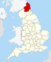
Northumberland (wym. [nɔrˈθʌmbərlənd]) – hrabstwo ceremonialne i historyczne oraz jednostka administracyjna typu unitary authority w północno-wschodniej Anglii, w regionie North East England, położone przy granicy ze Szkocją, nad Morzem Północnym.
Powierzchnia hrabstwa wynosi 5014 km², a liczba ludności – 316 002 (2016)[1]. Z gęstością zaludnienia wynoszącą 63,0 os./km² jest to najrzadziej zaludnione hrabstwo Anglii. Ośrodkiem administracyjnym hrabstwa jest Morpeth a największym miastem – Blyth. Innymi większymi miastami na terenie hrabstwa są Cramlington, Ashington, Bedlington oraz Berwick-upon-Tweed[2].
W północno-wschodniej części hrabstwa znajdują się niskie góry Cheviot Hills a na zachodzie i południowym zachodzie Góry Pennińskie. Wschodnią, nadmorską część zajmuje nizina. Na terenie hrabstwa znajduje się Park Narodowy Northumberland.
Na północy Northumberland graniczy ze Szkocją, na zachodzie z Kumbrią, na południowym zachodzie z hrabstwem Durham a na południowym wschodzie z Tyne and Wear.
Podział administracyjny
[edytuj | edytuj kod]Obecny
[edytuj | edytuj kod]Obszar hrabstwa ceremonialnego jest tożsamy z obszarem zajmowanym przez jednostkę administracyjną unitary authority Northumberland.
Do 2009
[edytuj | edytuj kod]
Przed reformą administracyjną przeprowadzoną w 2009 roku Northumberland było hrabstwem niemetropolitalnym, w którego skład wchodziło sześć dystryktów. Granice hrabstwa ceremonialnego były, tak jak i obecnie, identyczne z granicami jednostki administracyjnej.
Mapa
[edytuj | edytuj kod]
Zobacz też
[edytuj | edytuj kod]Przypisy
[edytuj | edytuj kod]- ↑ a b c MYE5: Population estimates: Population density for the local authorities in the UK, mid-2001 to mid-2016, [w:] Population Estimates for UK, England and Wales, Scotland and Northern Ireland – Mid-2016 [online], Office for National Statistics [dostęp 2017-10-21] (ang.).
- ↑ a b Office for National Statistics: KS101EW - Usual resident population. [w:] 2011 Census [on-line]. Nomis – Official labour market statistics, 2013-02-12. [dostęp 2022-06-05]. (ang.).
- ↑ Office for National Statistics: Built-up Area to Local Authority District (December 2011) Lookup in England and Wales. [w:] Open Geography Portal [on-line]. [dostęp 2022-06-05]. (ang.).
- ↑ Office for National Statistics: Built-up Area Sub Divisions (December 2011) Boundaries. [w:] Open Geography Potal [on-line]. [dostęp 2022-06-05]. (ang.).
Bibliografia
[edytuj | edytuj kod]- Northumberland, [w:] Encyclopædia Britannica [dostęp 2012-07-28] (ang.).
Text is available under the CC BY-SA 4.0 license; additional terms may apply.
Images, videos and audio are available under their respective licenses.


