Herefordshire
| Hrabstwo ceremonialne i unitary authority | |||||
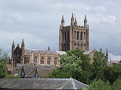
 Katedra w Hereford, stolicy hrabstwa | |||||
| |||||
| Państwo | |||||
|---|---|---|---|---|---|
| Kraj | |||||
| Region | |||||
| Siedziba | |||||
| Powierzchnia |
2180 km² | ||||
| Populacja (2011) • liczba ludności |
| ||||
| • gęstość |
84,2 os./km² | ||||
Położenie na mapie
| |||||
| Strona internetowa | |||||
Herefordshire – hrabstwo ceremonialne i historyczne oraz jednostka administracyjna typu unitary authority w zachodniej Anglii, w regionie West Midlands, położone przy granicy z Walią[1].
Powierzchnia hrabstwa wynosi 2180 km², a liczba ludności – 183 500[2]. Jest to jedno z najrzadziej zaludnionych hrabstwa Anglii, z gęstością zaludnienia wynoszącą 84,2 os./km². Stolicą oraz największym miastem jest Hereford, położony w środkowej części hrabstwa, posiadający status city. Inne większe miasta na terenie hrabstwa to Leominster, Ledbury oraz Ross-on-Wye[1].
Początki hrabstwa sięgają średniowiecza. W 1974 roku Herefordshire zostało połączone z sąsiednim Worcestershire w hrabstwo Hereford and Worcester, które funkcjonowało do 1998 roku, gdy hrabstwa ponownie rozdzielono.
Hrabstwo jest w przeważającej części nizinne, na jego wschodnim krańcu znajdują się wzgórza Malvern Hills. Główną rzeką przepływającą przez Herefordshire jest Wye. Hrabstwo ma charakter wiejski, a podstawę jego gospodarki stanowi rolnictwo, w szczególności sadownictwo, produkcja cydru, hodowla bydła i owiec[1].
Na północy Herefordshire graniczy z hrabstwem Shropshire, na wschodzie z Worcestershire, na południu z Gloucestershire, a na zachodzie z Walią.
Mapa
[edytuj | edytuj kod]
Przypisy
[edytuj | edytuj kod]- ↑ a b c Herefordshire, [w:] Encyclopædia Britannica [dostęp 2011-10-18] (ang.).
- ↑ Table P04 2011 Census: Usual resident population by five-year age group, local authorities in England and Wales. Office for National Statistics. [dostęp 2012-07-18]. (ang.).
- ↑ Office for National Statistics: KS101EW - Usual resident population. [w:] 2011 Census [on-line]. Nomis – Official labour market statistics, 2013-02-12. [dostęp 2022-06-05]. (ang.).
- ↑ Office for National Statistics: Built-up Area to Local Authority District (December 2011) Lookup in England and Wales. [w:] Open Geography Portal [on-line]. [dostęp 2022-06-05]. (ang.).
- ↑ Office for National Statistics: Built-up Area Sub Divisions (December 2011) Boundaries. [w:] Open Geography Potal [on-line]. [dostęp 2022-06-05]. (ang.).
Text is available under the CC BY-SA 4.0 license; additional terms may apply.
Images, videos and audio are available under their respective licenses.


