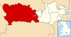
West Berkshire
| unitary authority | |
 Newbury | |
| Państwo | |
|---|---|
| Kraj | |
| Region | |
| Hrabstwo | |
| Siedziba | |
| Powierzchnia |
704,17 km² |
| Populacja (2011) • liczba ludności |
|
| • gęstość |
220 os./km² |
Położenie na mapie Berkshire
| |
| Strona internetowa | |
West Berkshire – dystrykt o statusie unitary authority w hrabstwie ceremonialnym Berkshire w Anglii. W 2011 roku dystrykt liczył 153 822 mieszkańców[1].
Miasta
[edytuj | edytuj kod]Inne miejscowości
[edytuj | edytuj kod]Aldermaston, Aldermaston Wharf, Aldworth, Ashampstead, Ashmore Green, Avington, Bagnor, Basildon, Beansheaf Farm, Beech Hill, Beedon, Beedon Common, Beenham, Benham Hill, Bloomfield Hatch, Boxford, Bradfield, Brightwalton, Brightwalton Green, Brimpton, Bucklebury, Burghfield, Burghfield Bridge, Burghfield Common, Calcot, Catmore, Chaddleworth, Chapel Row, Chieveley, Cold Ash, Colthrop, Combe, Compton, Crockham Heath, Crookham, Donnington, Downend, East Ilsley, East Garston, Eastbury, Elcot, Eling, Enborne, Enborne Row, Englefield, Farnborough, Fawley, Frilsham, Goddard’s Green, Great Shefford, Greenham, Hamstead Marshall, Hampstead Norreys, Heads Hill, Hermitage, Hoe Benham, Honey Bottom, Hungerford Newtown, Hunts Green, Hyde End, Inkpen, Inkpen Common, Kintbury, Lambourn, Lambourn Woodlands, Leckhampstead, Leverton, Lower Basildon, Lower Denford, Lower Padworth, Marlston, Midgham, Midgham Green, Mortimer Common, Ownham, Padworth, Padworth Common, Pangbourne, Peasemore, Pingewood, Purley on Thames, Purton, Sandleford, Shaw, Sheffield Bottom, Snelsmore, Speen, Stanford Dingley, Stanmore, Stratfield Mortimer, Streatley, Sulham, Sulhamstead, Theale, Tidmarsh, Tidmarsh with Sulham, Tilehurst, Tutts Clump, Ufton Nervet, Upper Basildon, Upper Bucklebury, Upper Denford, Upper Eddington, Upper Lambourn, Upper Woolhampton, Wash Water, Wasing, Welford, Westbrook, West Ilsley, West Woodhay, Whistley Green, Wickham Heath, Wickham, Wickham Green, Winterbourne, Wokefield, Woodlands St Mary, Woodspeen, Woolhampton, World’s End, Yattendon.
Przypisy
[edytuj | edytuj kod]- ↑ Area: West Berkshire (Local Authority). Neighbourhood Statistics (ONS). [dostęp 2016-04-25]. [zarchiwizowane z tego adresu (2016-10-03)]. (ang.).
Text is available under the CC BY-SA 4.0 license; additional terms may apply.
Images, videos and audio are available under their respective licenses.
