For faster navigation, this Iframe is preloading the Wikiwand page for 北纬32度线.

北纬32度线

北纬32度线在Earth的位置
32°
北纬32度线
使用下方服务在地图上显示所有坐标: OpenStreetMap 下载坐标为: KML GPX(所有坐标) GPX(主坐标) GPX(辅助坐标)
途中红线为北纬32度构成的美国新墨西哥州德克萨斯州边界部分
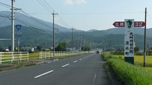
日本鹿儿岛县涌水町北纬32度标示牌

北纬32度线地球赤道平面以北32纬线。它穿过非洲亚洲太平洋北美洲大西洋

美国,该线构成了新墨西哥州德克萨斯州的一段边界。

1992年8月27日至1996年9月4日,该线确定了伊拉克禁飞区的南界,此后移到了北纬33度线[1]

在这条纬线上,夏至的白昼长14小时15分钟,冬至则为10小时3分钟。[2]

界线所经

本初子午线开始、向东,北纬32度线经过以下国家、地区或海域:

坐标 国家、地区或海域 备注
32°0′N 0°0′E / 32.000°N 0.000°E / 32.000; 0.000 (本初子午线)  阿尔及利亚
32°0′N 9°8′E / 32.000°N 9.133°E / 32.000; 9.133 (突尼斯)  突尼斯
32°0′N 10°47′E / 32.000°N 10.783°E / 32.000; 10.783 (利比亚)  利比亚
32°0′N 15°21′E / 32.000°N 15.350°E / 32.000; 15.350 (地中海) 地中海 锡德拉湾
32°0′N 19°58′E / 32.000°N 19.967°E / 32.000; 19.967 (利比亚)  利比亚
32°0′N 24°49′E / 32.000°N 24.817°E / 32.000; 24.817 (地中海) 地中海
32°0′N 34°44′E / 32.000°N 34.733°E / 32.000; 34.733 (以色列)  以色列
32°0′N 35°0′E / 32.000°N 35.000°E / 32.000; 35.000 (约旦河西岸地区) 约旦河西岸地区  以色列 巴勒斯坦控制
32°0′N 35°32′E / 32.000°N 35.533°E / 32.000; 35.533 (约旦)  约旦 安曼北侧掠过
32°0′N 39°0′E / 32.000°N 39.000°E / 32.000; 39.000 (沙特阿拉伯)  沙特阿拉伯
32°0′N 40°6′E / 32.000°N 40.100°E / 32.000; 40.100 (伊拉克)  伊拉克
32°0′N 47°42′E / 32.000°N 47.700°E / 32.000; 47.700 (伊朗)  伊朗
32°0′N 60°50′E / 32.000°N 60.833°E / 32.000; 60.833 (阿富汗)  阿富汗
32°0′N 69°18′E / 32.000°N 69.300°E / 32.000; 69.300 (巴基斯坦)  巴基斯坦 联邦直辖部落地区
俾路支省 - 约16公里
联邦直辖部落地区
开伯尔-普什图省
旁遮普省
32°0′N 74°50′E / 32.000°N 74.833°E / 32.000; 74.833 (印度)  印度 旁遮普邦
喜马偕尔邦
32°0′N 78°40′E / 32.000°N 78.667°E / 32.000; 78.667 (阿克赛钦) 阿克赛钦  中国 印度争议地区
32°0′N 78°44′E / 32.000°N 78.733°E / 32.000; 78.733 (中国)  中国 西藏自治区
青海省
西藏自治区(约12公里)
青海省(约6公里)
西藏自治区(约4公里)
青海省(约4公里)
西藏自治区
四川省
重庆市
陕西省
湖北省
河南省
安徽省
江苏省 — 从南京市南侧掠过
32°0′N 121°45′E / 32.000°N 121.750°E / 32.000; 121.750 (东海) 东海
32°0′N 130°11′E / 32.000°N 130.183°E / 32.000; 130.183 (日本)  日本 九州岛:
鹿儿岛县
宫崎县
32°0′N 131°30′E / 32.000°N 131.500°E / 32.000; 131.500 (太平洋) 太平洋
32°0′N 116°51′W / 32.000°N 116.850°W / 32.000; -116.850 (墨西哥)  墨西哥 下加利福尼亚州
索诺拉州
32°0′N 113°12′W / 32.000°N 113.200°W / 32.000; -113.200 (美国)  美国 亚利桑那州
新墨西哥州
新墨西哥州/德克萨斯州边境
德克萨斯州(穿过米德兰希尔斯伯勒市区)
路易斯安那州
密西西比州
亚拉巴马州
乔治亚州
32°0′N 80°50′W / 32.000°N 80.833°W / 32.000; -80.833 (大西洋) 大西洋  百慕大南侧掠过
 葡萄牙马德拉德塞塔群岛英语Desertas Islands南侧掠过
32°0′N 9°22′W / 32.000°N 9.367°W / 32.000; -9.367 (摩洛哥)  摩洛哥
32°0′N 2°56′W / 32.000°N 2.933°W / 32.000; -2.933 (阿尔及利亚)  阿尔及利亚

参见

参考

  1. ^ Containment: The Iraqi no-fly zones. BBC News. 1998-12-29 [2015-08-30]. (原始内容存档于2017-08-21). (英文)
  2. ^ Duration of Daylight. Astronomical Applications Department of the U.S. Naval Observatory. [2015-08-30]. (原始内容存档于2017-07-18). (英文)
{{bottomLinkPreText}} {{bottomLinkText}}
北纬32度线
Listen to this article

This browser is not supported by Wikiwand :(
Wikiwand requires a browser with modern capabilities in order to provide you with the best reading experience.
Please download and use one of the following browsers:

This article was just edited, click to reload
This article has been deleted on Wikipedia (Why?)

Back to homepage

Please click Add in the dialog above
Please click Allow in the top-left corner,
then click Install Now in the dialog
Please click Open in the download dialog,
then click Install
Please click the "Downloads" icon in the Safari toolbar, open the first download in the list,
then click Install
{{::$root.activation.text}}

Install Wikiwand

Install on Chrome Install on Firefox
Don't forget to rate us

Tell your friends about Wikiwand!

Gmail Facebook Twitter Link

Enjoying Wikiwand?

Tell your friends and spread the love:
Share on Gmail Share on Facebook Share on Twitter Share on Buffer

Our magic isn't perfect

You can help our automatic cover photo selection by reporting an unsuitable photo.

This photo is visually disturbing This photo is not a good choice

Thank you for helping!


Your input will affect cover photo selection, along with input from other users.

X

Get ready for Wikiwand 2.0 🎉! the new version arrives on September 1st! Don't want to wait?