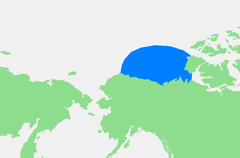
ബ്യൂഫോട്ട് കടൽ
| ബ്യൂഫോട്ട് കടൽ Beaufort Sea | |
|---|---|
 | |
| Coordinates | 72°N 137°W / 72°N 137°W |
| Type | Sea |
| Basin countries | Canada, United States |
| Surface area | 178,000 km2 (69,000 sq mi) |
| Average depth | 124 m (407 ft) |
| Max. depth | 4,683 m (15,364 ft) |
| Water volume | 22,000 km3 (1.8×10¹⁰ acre⋅ft) |
| Frozen | Almost all year round |
| References | [1][2][3] |
ആർട്ടിക് സമുദ്രത്തിലെ ഒരു കടലാണ് ബ്യൂഫോട്ട് കടൽ (Beaufort Sea French: Mer de Beaufort) [4]
നോർത്ത് വെസ്റ്റ് ടെറിടറീസ്, യൂകോൺ, അലാസ്ക എന്നിവയ്ക് വടക്കായും, കനേഡിയൻ ആർട്ടിക് ദ്വീപസമൂഹത്തിനു പടിഞ്ഞാറായും സ്ഥിതിചെയ്യുന്നു. ഐറിഷ് ജലമാപകനായ സർ ഫ്രാൻസിസ് ബ്യൂഫോട്ടിന്റെ പേരിൽനിന്നുമാണ് ഈ കടലിന്റെ പേർ വന്നത്. കാനഡയിലെ ഏറ്റവും വലിയ നദിയായ മകിൻസ്കി നദി ഈ കടലിന്റെ കനേഡിയൻ ഭാഗത്താണ് പതിക്കുനത്.
ഏതാണ്ട് വർഷം മുഴുവനും ഹിമാവൃതമായിക്കിടക്കുന്ന ഇവിടെ കഠിനമായ കാലാവസ്ഥ അനുഭവപ്പെടുന്നു. പുരാതനകാലത്ത് തീരത്തിനടുത്തുനിന്നും 100 km (62 mi) വീതിയുള്ള പ്രദേശത്ത് മാത്രം ഓഗസ്റ്റ്–സപ്തംബർ മാസങ്ങളിൽ മഞ്ഞുരുകിയിരുന്നുവെങ്കിലും സമീപകാലത്ത് ആർടികിലെ കാലാവസ്ഥാവ്യതിയാനം നിമിത്തം മഞ്ഞുരുകുന്ന പ്രദേശത്തിന്റെ വിസ്തീർണ്ണം അധികമായിട്ടുണ്ട്. തീരപ്രദേശങ്ങളിലെ ജനസാന്ദ്രത വളരെ കുറവാണ്. പെട്രോളിയത്തിന്റെയും പ്രകൃതിവാതകത്തിന്റെയും നിക്ഷേപങ്ങൾ ഇവിടെയുണ്ട് 1950- 1980 കാലഘട്ടത്തിലാണ് ഈ നിക്ഷേപങ്ങൾ കണ്ടെത്തപ്പെട്ടത്.
അതിർത്തികൾ
[തിരുത്തുക]അന്താരാഷ്ട്ര ഹൈഡ്രോഗ്രാഫിക് ഓർഗനൈസേഷൻ ബ്യൂഫോട്ട് കടലിന്റെ അതിർത്തികൾ നിർണ്ണയിച്ചിരിക്കുന്നത് താഴേപ്പറയുന്ന രീതിയിലാണ്.[5]
വടക്ക് അലാസ്കയിലെ പോയിന്റെ ബാറൊ മുതൽ പ്രിൻസ് പാട്രിക് ദ്വീപിലെ ലാന്റ്സ് എന്ഡ് വരെയുള്ള സാങ്കൽപികരേഖ(76°16′N 124°08′W / 76.267°N 124.133°W).
കിഴക്ക് ലാന്റ്സ് എന്ഡിൽനിന്നും പ്രിൻസ് പാട്രിക് ദ്വീപിന്റെ തെക്ക് പടിഞ്ഞാറൻ തീരത്തിലൂടെ ഗ്രിഫിത്ത് പോയന്റിലൂടെ കേപ് പ്രിൻസ് ആൽഫ്രഡിലേക്കുള്ള സാങ്കൽപികരേഖ, തുടർന്ന് ബാങ്ക്സ് ദ്വീപിന്റെ വടക്കുപടിഞ്ഞാറേ അറ്റത്തുനിന്നും ബാങ്ക്സ് ദ്വീപിന്റെ പടിഞ്ഞാറേ തീരത്തിലൂടെ ആ ദ്വീപിന്റെ തെക്കുപടിഞ്ഞാറൻ അറ്റമായ കേപ് കെല്ലെറ്റ്, അവിടെനിന്നും വൻകരയിലെ കേപ് ബാത്തസ്റ്റിലേക്കുള്ള രേഖ(70°36′N 127°32′W / 70.600°N 127.533°W).
അതിർത്തിത്തർക്കം
[തിരുത്തുക]
കാനഡയിലെ ടെറിറ്ററിയായ യൂകോണിന്റെയും അമേരിക്കൻ സംസ്ഥാനമായ അലാസ്കയുടെയും ഇടയിലെ ഈ കടലിൽ സ്ഥിതിചെയ്യുന്ന ത്രികോണാകൃതിയിലുള്ള ഭാഗത്തെച്ചൊല്ലി കാനഡയും അമേരിക്കയും തമ്മിൽ അതിർത്തിത്തർക്കം നിലനിൽക്കുന്നുണ്ട്. ഇവിടെയുള്ള എണ്ണയുടെയും പ്രകൃതിവാതകത്തിന്റെയും നിക്ഷേപങ്ങളാണ് ഈ തർക്കതിനുപിന്നിലെ ഒരു പ്രധാനകാരണം[6][7][8] ഇവിടെ 1,700,000,000 m3 (6.0×10¹⁰ cu ft) പ്രകൃതിവാതകത്തിന്റെയും (ഏകദേശം ഇരുപത് വർഷം കാനഡക്കാവശ്യവായ പ്രകൃതിവാതകം) 1,000,000,000 m3 (3.5×10¹⁰ cu ft) എണ്ണയുടെയും നിക്ഷേപമുണ്ടെന്ന് കരുതപ്പെടുന്നു.[9]
ഭൂമിശാസ്ത്രം
[തിരുത്തുക]
അലാസ്കയിലെ കൊംഗാകുട്, യൂകോണിലെ ഫിർത് നദി തുടങ്ങിയ പല നദികളും ബ്യൂഫോട് കടലിൽ പതിക്കുന്നുണ്ട്, ഇവയിൽ ഏറ്റവും വലിയ നദി കാനഡയിലെ ഏറ്റവും വലിയ നദികൂടിയായ മകിൻസ്കി നദിയാണ്. ഈ കടലിന്റെ കനേഡിയൻ ഭാഗത്തായി ടക്ടോയാക്റ്റകിനും പടിഞ്ഞാറായാണ് മകിൻസ്കി, ബ്യൂഫോട് കടലിൽ പതിക്കുന്നത്. വൻകരത്തട്ട് (Continental shelf) പൊതുവേ വീതി കുറഞ്ഞതാണ്, പ്രത്യേകിച്ചും അലാസ്കൻ ഭാഗത്ത് പോയിന്റ് ബാരോയുടെ കിഴക്കൻ പ്രദേശങ്ങളിൽ. മകിൻസ്കിയുടെ അഴിമുഖത്ത് വീതി കൂടുന്നുവെങ്കിലും ഒരിക്കലും 145 km (90 mi) കൂടുതലാകുന്നില്ല.
അവലംബം
[തിരുത്തുക]- ↑ R. Stein, Arctic Ocean Sediments: Processes, Proxies, and Paleoenvironment, p. 37
- ↑ Beaufort Sea, Great Soviet Encyclopedia (in Russian)
- ↑ Beaufort Sea, Encyclopædia Britannica on-line
- ↑ John Wright (30 November 2001). The New York Times Almanac 2002. Psychology Press. p. 459. ISBN 978-1-57958-348-4. Retrieved 29 November 2010.
- ↑ "Limits of Oceans and Seas, 3rd edition" (PDF). International Hydrographic Organization. 1953. Archived from the original (PDF) on 2014-04-07. Retrieved 6 February 2010.
- ↑ Donald Rothwell (1996). The Polar Regions and the Development of International Law. Cambridge studies in international and comparative law. Vol. 3. Cambridge University Press. pp. 174, 176. ISBN 978-0-521-56182-2.
- ↑ Northern interests and Canadian foreign policy Archived 16 August 2010 at the Wayback Machine., Associate Director Centre for Military and Strategic Studies, University of Calgary
- ↑ Beaufort Sea Areawide 2006, Tract Map No.8, State of Alaska Department of Natural Resources, Division of oil and gas
- ↑ US-Canada Arctic border dispute key to maritime riches, BBC News, 2 August 2010
| ആർട്ടിക് സമുദ്രം | അമുൻഡ്സെൻ ഉൾക്കടൽ · ബെരെന്റ്സ് കടൽ · ബേഫോട്ട് കടൽ · ബെറിങ്ങ് കടലിടുക്ക് · ചുക്ചി കടൽ · കിഴക്കൻ സൈബീരിയൻ കടൽ · ഫ്രാം കടലിടുക്ക് · ഗ്രീൻലാൻഡ് കടൽ · ബൂത്തിയ ഉൾക്കടൽ · കാര കടൽ · Kara Strait · ലാപ്ടേവ് കടൽ · ലിങ്കൺ കടൽ · Prince Gustav Adolf Sea · Pechora Sea · Wandel Sea · വെള്ളക്കടൽ |
|---|---|
| അറ്റ്ലാന്റിക് മഹാസമുദ്രം | അഡ്രിയാറ്റിക് സമുദ്രം · ഈജിയൻ കടൽ · Alboran Sea · Archipelago Sea · അർജെന്റൈൻ കടൽ · ബാഫിൻ ഉൾക്കടൽ · Balearic Sea · ബാൾട്ടിക് കടൽ · Bay of Biscay · Bay of Bothnia · Bay of Campeche · Bay of Fundy · കരിങ്കടൽ · Bothnian Sea · കരീബിയൻ കടൽ · സെൽട്ടിക് കടൽ · ഡേവിസ് കടലിടുക്ക് · ഡെന്മാർക്ക് കടലിടുക്ക് · ഇംഗ്ലീഷ് ചാനൽ · Foxe Basin · ഗ്രീൻലാൻഡ് കടൽ · Gulf of Bothnia · Gulf of Finland · Gulf of Guinea · മെക്സിക്കോ കടലിടുക്ക് · സെന്റ് ലോറൻസ് ഉൾക്കടൽ · Gulf of Venezuela · ഹഡ്സൺ ഉൾക്കടൽ · James Bay · അയോണിയൻ കടൽ · ഐറിഷ് കടൽ · Irminger Sea · ലാബ്രഡോർ കടൽ · Levantine Sea · Libyan Sea · ലിഗൂറിയൻ കടൽ · മർമറ കടൽ · മദ്ധ്യധരണ്യാഴി · Myrtoan Sea · വടക്കൻ കടൽ · നോർവീജിയൻ കടൽ · സരഗാസോ കടൽ · Sea of Åland · അസോവ് കടൽ · Sea of Crete · Sea of the Hebrides · Thracian Sea · ടൈറീനിയൻ കടൽ |
| ഇന്ത്യൻ മഹാസമുദ്രം | ആൻഡമാൻ കടൽ · അറബിക്കടൽ · ബംഗാൾ ഉൾക്കടൽ · ഏഡൻ ഉൾക്കടൽ · അക്വാബ ഉൾക്കടൽ · ഘാംബട്ട് ഉൾക്കടൽ · കച്ച് കടലിടുക്ക് · ഒമാൻ ഗൾഫ് · സൂയസ് ഉൽക്കടൽ · ലക്ഷദ്വീപ കടൽ · മൊസാംബിഖ് ചാനൽ · പേർഷ്യൻ ഗൾഫ് · ചെങ്കടൽ · മലാക്കാ കടലിടുക്ക് · തിമൂർ സമുദ്രം |
| ശാന്തസമുദ്രം | അറഫുര കടൽ · Bali Sea · Banda Sea · ബെറിംഗ് കടൽ · Bismarck Sea · Bohai Sea · Bohol Sea · Camotes Sea · സെലിബെസ് കടൽ · Ceram Sea · Chilean Sea · കോറൽ കടൽ · കിഴക്കൻ ചൈനാക്കടൽ · Flores Sea · ഗൾഫ് ഓഫ് അലാസ്ക · ഗൾഫ് ഓഫ് കാലിഫോർണിയ · Gulf of Carpentaria · തായ്ലാന്റ് ഉൾക്കടൽ · Gulf of Tonkin · Halmahera Sea · ജാവാ കടൽ · Koro Sea · മകസ്സാർ കടലിടുക്ക് · Molucca Sea · മോറോ കടലിടുക്ക് · ഫിലിപ്പൈൻ കടൽ · Salish Sea · Savu Sea · ജപ്പാൻ കടൽ · ഒഖോറ്റ്സ്ക് കടൽ · Seto Inland Sea · Sibuyan Sea · Solomon Sea · ദക്ഷിണ ചൈനാക്കടൽ · സുലു കടൽ · ടാസ്മാൻ കടൽ · വിസയൻ കടൽ · മഞ്ഞക്കടൽ |
| ദക്ഷിണ സമുദ്രം | അമുൺസെൻ കടൽ · Bellingshausen Sea · Cooperation Sea · Cosmonauts Sea · Davis Sea · D'Urville Sea · King Haakon VII Sea · Lazarev Sea · Riiser-Larsen Sea · Mawson Sea · റോസ് കടൽ · സ്കോട്ടിയ കടൽ · Somov Sea · Weddell Sea |
| കരയാൽ ചുറ്റപ്പെട്ട കടലുകൾ | |
Text is available under the CC BY-SA 4.0 license; additional terms may apply.
Images, videos and audio are available under their respective licenses.
