പ്രിൻസ് പാട്രിക് ദ്വീപ്
 Prince Patrick Island, showing the Mould Bay weather station | |
 | |
| Geography | |
|---|---|
| Location | Northern Canada |
| Coordinates | 76°45′N 119°30′W / 76.750°N 119.500°W |
| Archipelago | Queen Elizabeth Islands Canadian Arctic Archipelago |
| Area | 15,848 km2 (6,119 sq mi) |
| Area rank | 55th |
| Highest elevation | 279 m (915 ft) |
| Highest point | unnamed |
| Administration | |
കാനഡ | |
| Territory | Northwest Territories |
| Demographics | |
| Population | Uninhabited |
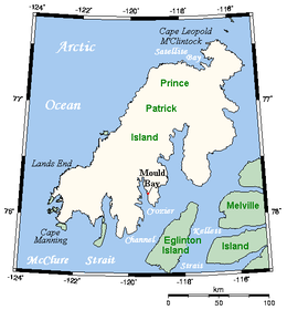
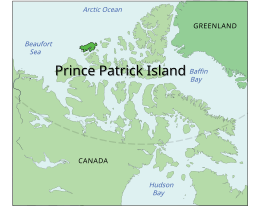
പ്രിൻസ് പാട്രിക് ദ്വീപ്, കാനഡയുടെ വടക്കുപടിഞ്ഞാറൻ പ്രവിശ്യകളിലുള്ള ക്വീൻ എലിസബത്ത് ദ്വീപുകളുടെ ഏറ്റവും പടിഞ്ഞാറ് ഭാഗത്തുള്ള ദ്വീപും കാനേഡിയൻ ആർട്ടിക് ദ്വീപസമൂഹത്തിലെ ഒരു അംഗവുമാണ്. ഏകദേശം15,848 ചതുരശ്ര കിലോമീറ്റർ (6,119 ചതുരശ്ര മൈൽ)[1] വിസ്തീർണ്ണമുള്ള ഈ ദ്വീപ് വലിപ്പത്തിൽ ലോകത്തെ 55-ആം സ്ഥാനത്തുള്ള ദ്വീപും കാനഡയുടെ പതിനാലാമത്തെ വലിയ ദ്വീപുമാണ്. ചരിത്രപരമായി വർഷം മുഴുവൻ മഞ്ഞുറഞ്ഞുകിടക്കുന്ന ഈ ദ്വീപ് കാനഡയിലെ എത്തിച്ചേരാൻ ഏറ്റവും പ്രയാസമുള്ള പ്രദേശങ്ങളിലൊന്നാണ്.
മ്ക്ലൂർ കടലിടുക്കിന്റെ പ്രവേശനകവാടത്തിൽ സ്ഥിതിചെയ്യുന്ന പ്രിൻസ് പാട്രിക് ദ്വീപ് മനുഷ്യവാസമില്ലാത്തതാണ്. കാലാവസ്ഥാ നിരീക്ഷണകേന്ദ്ര ശൃംഖലയെ പിന്തുണയ്ക്കുന്ന ഒരു കാനഡ-അമേരിക്ക സൈനിക സംരംഭത്തിന്റെ ഭാഗമായി 1948 ൽ ഒരു ഹൈ ആർക്കിക് വെതർ സ്റ്റേഷനും ("HAWS") അനുബന്ധമായി മാൾഡ് ബേ എന്ന പേരിൽ ഒരു താൽക്കാലിക എയർസ്ട്രിപ്പും ഇവിടെ തുറന്നിരുന്നു. 1948 മെയ് 14 ന് പതിവായുള്ള കാലാവസ്ഥ നിരീക്ഷണങ്ങൾ ഇവിടെ തുടങ്ങി. 10 മുതൽ 40 പേരടങ്ങിയ ഒരു താൽക്കാലിക ജീവനക്കാരും ഇവിടെയുണ്ടായിരുന്നു. വേനൽക്കാലങ്ങളിൽ അവശ്യ സാധനങ്ങൾ എത്തുന്നമുറയ്ക്ക് സാധാരണയായി ജീവനക്കാരുടെ എണ്ണം കൂട്ടാറുണ്ട്.
യു.എസ്. ദേശീയ കാലാവസ്ഥാ സേവന പങ്കാളിത്തത്തിന്റെ കാലത്ത് ഈ സ്ഥലം ജോയിന്റ് ആർട്ടിക് വെതർ സ്റ്റേഷൻ ("JAWS") എന്നറിയപ്പെട്ടു. ഭരണനിർവ്വഹണ ഉദ്യോഗസ്ഥന്മാർ കാനഡ, യു.എസ്. എന്നിവിടങ്ങളിൽനിന്നു മാറിമാറി നിയമിക്കപ്പെട്ടിരുന്നു. ഇതില അമേരിക്കൻ പങ്കാളിത്തം 1972 ൽ അവസാനിച്ചു. ബജറ്റ് വെട്ടിക്കുറച്ചതിന്റെ ഫലമായി 1997 ൽ ഈ സ്റ്റേഷൻ അടച്ചുപൂട്ടി. കേന്ദ്ര കെട്ടിടങ്ങളിൽ നിന്നും നിരീക്ഷണാലയത്തിൽനിന്നും താഴെയായി എയർസ്ട്രിപ്പിലെ ഒരു പുതിയ സ്ഥലത്ത് ഇതൊരു യാന്ത്രിക കാലാവസ്ഥാ കേന്ദ്രമായി മാറ്റിയെടുത്തു സ്ഥാപിക്കപ്പെട്ടു.![photo[പ്രവർത്തിക്കാത്ത കണ്ണി] of the now abandon Mould Bay Weather Station](https://upload.wikimedia.org/wikipedia/commons/8/86/Mould_Bay_Weather_Station.jpg)
കാലാവസ്ഥ
[തിരുത്തുക]| Mould Bay Airport, 1981–2010 normals, extremes 1948–present പ്രദേശത്തെ കാലാവസ്ഥ | |||||||||||||
|---|---|---|---|---|---|---|---|---|---|---|---|---|---|
| മാസം | ജനു | ഫെബ്രു | മാർ | ഏപ്രി | മേയ് | ജൂൺ | ജൂലൈ | ഓഗ | സെപ് | ഒക് | നവം | ഡിസം | വർഷം |
| റെക്കോർഡ് കൂടിയ °C (°F) | −5.3 (22.5) |
−4.9 (23.2) |
−6.7 (19.9) |
−0.5 (31.1) |
6.3 (43.3) |
18.0 (64.4) |
22.7 (72.9) |
16.3 (61.3) |
7.8 (46) |
2.5 (36.5) |
−1.7 (28.9) |
−2.6 (27.3) |
22.7 (72.9) |
| ശരാശരി കൂടിയ °C (°F) | −29.4 (−20.9) |
−30.0 (−22) |
−27.6 (−17.7) |
−19.1 (−2.4) |
−7.4 (18.7) |
2.9 (37.2) |
6.7 (44.1) |
3.0 (37.4) |
−3.8 (25.2) |
−14.1 (6.6) |
−23.1 (−9.6) |
−27.0 (−16.6) |
−14.1 (6.6) |
| പ്രതിദിന മാധ്യം °C (°F) | −33.1 (−27.6) |
−33.9 (−29) |
−31.4 (−24.5) |
−23.0 (−9.4) |
−10.4 (13.3) |
0.6 (33.1) |
4.0 (39.2) |
0.9 (33.6) |
−6.2 (20.8) |
−17.7 (0.1) |
−26.6 (−15.9) |
−30.5 (−22.9) |
−17.3 (0.9) |
| ശരാശരി താഴ്ന്ന °C (°F) | −36.9 (−34.4) |
−37.6 (−35.7) |
−34.9 (−30.8) |
−26.8 (−16.2) |
−13.5 (7.7) |
−1.7 (28.9) |
1.2 (34.2) |
−1.3 (29.7) |
−8.5 (16.7) |
−21.3 (−6.3) |
−30.2 (−22.4) |
−34.0 (−29.2) |
−20.4 (−4.7) |
| താഴ്ന്ന റെക്കോർഡ് °C (°F) | −52.2 (−62) |
−53.9 (−65) |
−54.7 (−66.5) |
−46.1 (−51) |
−29.6 (−21.3) |
−14.4 (6.1) |
−3.9 (25) |
−13.5 (7.7) |
−26.1 (−15) |
−38.9 (−38) |
−44.4 (−47.9) |
−52.8 (−63) |
−54.7 (−66.5) |
| Wind chill | −72.8 | −72.0 | −70.1 | −60.5 | −39.2 | −22.5 | −10.8 | −17.3 | −35.0 | −52.3 | −57.9 | −68.8 | −72.8 |
| മഴ/മഞ്ഞ് mm (inches) | 4.5 (0.177) |
4.6 (0.181) |
4.2 (0.165) |
3.4 (0.134) |
10.8 (0.425) |
9.8 (0.386) |
13.8 (0.543) |
23.8 (0.937) |
18.1 (0.713) |
12.9 (0.508) |
6.7 (0.264) |
4.5 (0.177) |
117.2 (4.614) |
| വർഷപാതം mm (inches) | 0.0 (0) |
0.0 (0) |
0.0 (0) |
0.0 (0) |
0.0 (0) |
3.6 (0.142) |
10.0 (0.394) |
11.7 (0.461) |
2.2 (0.087) |
0.0 (0) |
0.0 (0) |
0.0 (0) |
27.5 (1.083) |
| മഞ്ഞുവീഴ്ച cm (inches) | 5.4 (2.13) |
5.8 (2.28) |
5.1 (2.01) |
4.7 (1.85) |
15.0 (5.91) |
6.6 (2.6) |
3.8 (1.5) |
12.9 (5.08) |
18.5 (7.28) |
16.1 (6.34) |
9.0 (3.54) |
6.3 (2.48) |
109.2 (42.99) |
| ശരാ. മഴ/മഞ്ഞു ദിവസങ്ങൾ (≥ 0.2 mm) | 6.1 | 6.6 | 6.4 | 4.9 | 10.1 | 6.3 | 9.0 | 13.3 | 12.8 | 11.6 | 9.6 | 6.9 | 103.6 |
| ശരാ. മഴ ദിവസങ്ങൾ (≥ 0.2 mm) | 0.0 | 0.0 | 0.0 | 0.0 | 0.0 | 2.9 | 7.8 | 6.2 | 1.1 | 0.0 | 0.0 | 0.0 | 18.0 |
| ശരാ. മഞ്ഞു ദിവസങ്ങൾ (≥ 0.2 cm) | 6.6 | 6.9 | 6.8 | 5.8 | 12.2 | 4.2 | 3.4 | 8.9 | 12.5 | 12.2 | 10.0 | 7.1 | 96.5 |
| % ആർദ്രത | 69.5 | 67.4 | 64.6 | 73.2 | 82.0 | 81.3 | 79.6 | 84.8 | 88.2 | 80.3 | 73.3 | 69.6 | 76.1 |
| മാസം സൂര്യപ്രകാശം ലഭിക്കുന്ന ശരാശരി മണിക്കൂറുകൾ | 0.0 | 0.0 | 97.9 | 287.5 | 267.9 | 297.2 | 254.1 | 121.0 | 49.6 | 15.5 | 0.0 | 0.0 | 1,390.5 |
| ലഭിക്കാൻ സാധ്യതയുള്ള സൂര്യപ്രകാശ ശതമാനം | 0.0 | 0.0 | 27.8 | 49.9 | 36.0 | 41.3 | 34.2 | 17.4 | 11.6 | 6.9 | 0.0 | 0.0 | 25.0 |
| ഉറവിടം: Environment Canada[2][3][4][5] | |||||||||||||
അവലംബം
[തിരുത്തുക]
- ↑ Prince Patrick Island Archived 2013-01-22 at the Wayback Machine. at the Atlas of Canada
- ↑ "Mould Bay A". Canadian Climate Normals 1981–2010. Environment Canada. Climate ID: 2502700. Archived from the original (CSV (3069 KB)) on 2020-03-13. Retrieved 2014-01-09.
- ↑ "July 2001". Canadian Climate Data. Environment Canada. Retrieved 14 May 2016.
- ↑ "June 2012". Canadian Climate Data. Environment Canada. Retrieved 14 May 2016.
- ↑ "August 2011". Canadian Climate Data. Environment Canada. Retrieved 14 May 2016.
- ↑ Daily Data Report for March 2017
Text is available under the CC BY-SA 4.0 license; additional terms may apply.
Images, videos and audio are available under their respective licenses.
