ലാബ്രഡോർ കടൽ
| ലാബ്രഡോർ കടൽ | |
|---|---|
 Past sunset at Labrador Sea, off the coast of Paamiut, Greenland, in July 2009. | |
 | |
| Coordinates | 61°N 56°W / 61°N 56°W |
| Type | Sea |
| Basin countries | Canada, Greenland |
| Max. length | c. 1,000 km (621 mi) |
| Max. width | c. 900 km (559 mi) |
| Surface area | 841,000 km2 (324,700 sq mi) |
| Average depth | 1,898 m (6,227 ft) |
| Max. depth | 4,316 m (14,160 ft) |
| References | [1][2] |
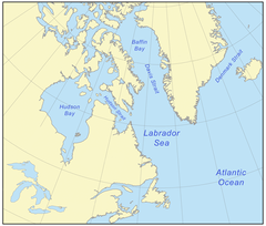
ലാബ്രഡോർ ഉപദ്വീപിനും ഗ്രീൻലാൻഡിനും ഇടയിലായി സ്ഥിതിചെയ്യുന്ന ഉത്തര അറ്റ്ലാന്റിക്ക് സമുദ്രത്തിന്റെ ഭാഗമായ ഒരു കടലാണ് ലാബ്രഡോർ കടൽ (Labrador Sea French: mer du Labrador, Danish: Labradorhavet). ഈ കടലിന്റെ തെക്ക്പടിഞ്ഞാറും വടക്ക്പടിഞ്ഞാറും വടക്ക്കിഴക്കും വൻകരത്തട്ടാണ്. വടക്ക് ഡേവിസ് കടലിടുക്ക് ലാബ്രഡോർ കടലിനെ ബാഫിൻ ഉൾക്കടലുമായി ബന്ധിപ്പിക്കുന്നു.[3].
ഏകദേശം ആറു കോടി വർഷം മുമ്പ് ഗ്രീൻലാന്റ് ഫലകം വടക്കേ അമേരിക്കൻ ഫലകത്തിൽനിന്നും അകലാൻ തുടങ്ങിയപ്പോളാണ് ലാബ്രഡോർ കടൽ രൂപം പ്രാപിച്ചത്, ഈ പ്രതിഭാസം നാലുകോടി വർഷം മുമ്പാണ് അവസാനിച്ചത്. ലോകത്തിലെ ഏറ്റവും വലിയ ടർബിഡിറ്റി പ്രവാഹങ്ങളിൽ ഒന്നായ നോർത്ത് വെസ്റ്റ് അറ്റ്ലാന്റിക് മിഡ് ഓഷ്യൻ ചാനൽ (NAMOC) ലാബ്രഡോർ കടലിന്റെ അടിത്തട്ടിലൂടെ അറ്റ്ലാന്റിക് സമുദ്രത്തിലേക്ക് ഒഴുകുന്നു.
ചരിത്രം
[തിരുത്തുക]ഏകദേശം 40 ദശലക്ഷം വർഷങ്ങൾക്ക് മുമ്പ് (പാലിയോസീൻ) നോർത്ത് അമേരിക്കൻ പ്ലേറ്റും ഗ്രീൻലാൻഡ് പ്ലേറ്റും വേർതിരിക്കുന്നതിനായാണ് ലാബ്രഡോർ കടൽ രൂപപ്പെട്ടത്.[2]ഒരു അവസാദ തടം, ക്രറ്റേഷ്യസ് കാലഘട്ടത്തിൽ രൂപംകൊണ്ട ഭൂഖണ്ഡാന്തര ചരിവിൽ മൂടപ്പെട്ടിരുന്നു.[2] പാലിയോസീനിൽ ഡേവിസ് കടലിടുക്കിലും ബാഫിൻ ബേയിലുമുള്ള അഗ്നിപർവ്വത സ്ഫോടനങ്ങളിലൂടെ ഉണ്ടായ പിക്രിറ്റുകളുടെയും ബസാൾട്ടിന്റെയും ഫലമായി മാഗ്മാറ്റിക് സീ-ഫ്ലോർ വ്യാപനത്തിന്റെ തുടക്കമായി.[2]
ബിസി 500 നും എ ഡി 1300 നും ഇടയിൽ, കടലിന്റെ തെക്കൻ തീരത്ത് ഡോർസെറ്റ്, ബിയോത്ത്ക്, ഇൻയൂട്ട് കുടിയേറ്റക്കാർ ഉണ്ടായിരുന്നു. ഡോർസെറ്റ് ഗോത്രങ്ങൾക്കുശേഷം പിന്നീട് തുലെ ജനതയായി.[4]
അതിർത്തികൾ
[തിരുത്തുക]അന്താരാഷ്ട്ര ഹൈഡ്രോഗ്രാഫിക് ഓർഗനൈസേഷൻ ലാബ്രഡോർ കടലിന്റെ അതിർത്തികൾ നിർണ്ണയിച്ചിരിക്കുന്നത് താഴേപ്പറയുന്ന രീതിയിലാണ്.[5]
വടക്ക്: ഡേവിസ് കടലിടുക്കിന്റെ തെക്കെ അതിർത്തി - ഗ്രീൻലാന്റിനും ലാബ്രഡോറിനും ഇടയിൽ 60° ഉത്തര അക്ഷാംശം .
കിഴക്ക് കേപ്പ് സെന്റ് ഫ്രാൻസിസ് (ന്യൂഫൗണ്ട്ലാന്റ്) മുതൽ 47°45′N 52°27′W / 47.750°N 52.450°W കേപ്പ് ഫെയർവെൽ (ഗ്രീൻലാന്റ്)വരെയുള്ള സാങ്കൽപികരേഖ.
പടിഞ്ഞാറ് : ന്യൂഫൗണ്ടൻലാൻഡ് ആന്റ് ലാബ്രഡോരിന്റെ കിഴക്കൻ തീരം, സെന്റ് ലോറൻസ് ഉൾക്കടലിന്റെ വടക്ക് കിഴക്കൻ അതിർത്തി കേപ് ബോൾഡ് മുതൽ ( കിർപോൺ ദ്വീപ്ന്റെ വടക്കേയറ്റം) 51°40′N 55°25′W / 51.667°N 55.417°W) മുതൽ ബെല്ലെ ദ്വീപിന്റെ കിഴക്കേയറ്റം (52°02′N 55°15′W / 52.033°N 55.250°W) വരെയും അവിടെ നിന്നും കേപ് സെന്റ് ചാൾസിന്റെ കിഴക്കേയറ്റം (52°13'N) വരെയുമുള്ള സാങ്കൽപികരേഖ. .
അവലംബം
[തിരുത്തുക]- ↑ "Labrador" (in Russian). Great Soviet Encyclopedia.
((cite web)): CS1 maint: unrecognized language (link) - ↑ 2.0 2.1 2.2 2.3 Wilson, R. C. L; London, Geological Society of (2001). "Non-volcanic rifting of continental margins: a comparison of evidence from land and sea". Geological Society, London, Special Publications. 187: 77. doi:10.1144/GSL.SP.2001.187.01.05. ISBN 978-1-86239-091-1.
- ↑ Encyclopædia Britannica. "Labrador Sea". Retrieved 2008-02-03.
- ↑ Grønlands forhistorie, ed. Hans Christian Gulløv, Gyldendal 2005, ISBN 87-02-01724-5
- ↑ "Limits of Oceans and Seas, 3rd edition" (PDF). International Hydrographic Organization. 1953. Archived from the original (PDF) on 2011-10-08. Retrieved 6 February 2010.
| ആർട്ടിക് സമുദ്രം | അമുൻഡ്സെൻ ഉൾക്കടൽ · ബെരെന്റ്സ് കടൽ · ബേഫോട്ട് കടൽ · ബെറിങ്ങ് കടലിടുക്ക് · ചുക്ചി കടൽ · കിഴക്കൻ സൈബീരിയൻ കടൽ · ഫ്രാം കടലിടുക്ക് · ഗ്രീൻലാൻഡ് കടൽ · ബൂത്തിയ ഉൾക്കടൽ · കാര കടൽ · Kara Strait · ലാപ്ടേവ് കടൽ · ലിങ്കൺ കടൽ · Prince Gustav Adolf Sea · Pechora Sea · Wandel Sea · വെള്ളക്കടൽ |
|---|---|
| അറ്റ്ലാന്റിക് മഹാസമുദ്രം | അഡ്രിയാറ്റിക് സമുദ്രം · ഈജിയൻ കടൽ · Alboran Sea · Archipelago Sea · അർജെന്റൈൻ കടൽ · ബാഫിൻ ഉൾക്കടൽ · Balearic Sea · ബാൾട്ടിക് കടൽ · Bay of Biscay · Bay of Bothnia · Bay of Campeche · Bay of Fundy · കരിങ്കടൽ · Bothnian Sea · കരീബിയൻ കടൽ · സെൽട്ടിക് കടൽ · ഡേവിസ് കടലിടുക്ക് · ഡെന്മാർക്ക് കടലിടുക്ക് · ഇംഗ്ലീഷ് ചാനൽ · Foxe Basin · ഗ്രീൻലാൻഡ് കടൽ · Gulf of Bothnia · Gulf of Finland · Gulf of Guinea · മെക്സിക്കോ കടലിടുക്ക് · സെന്റ് ലോറൻസ് ഉൾക്കടൽ · Gulf of Venezuela · ഹഡ്സൺ ഉൾക്കടൽ · James Bay · അയോണിയൻ കടൽ · ഐറിഷ് കടൽ · Irminger Sea · ലാബ്രഡോർ കടൽ · Levantine Sea · Libyan Sea · ലിഗൂറിയൻ കടൽ · മർമറ കടൽ · മദ്ധ്യധരണ്യാഴി · Myrtoan Sea · വടക്കൻ കടൽ · നോർവീജിയൻ കടൽ · സരഗാസോ കടൽ · Sea of Åland · അസോവ് കടൽ · Sea of Crete · Sea of the Hebrides · Thracian Sea · ടൈറീനിയൻ കടൽ |
| ഇന്ത്യൻ മഹാസമുദ്രം | ആൻഡമാൻ കടൽ · അറബിക്കടൽ · ബംഗാൾ ഉൾക്കടൽ · ഏഡൻ ഉൾക്കടൽ · അക്വാബ ഉൾക്കടൽ · ഘാംബട്ട് ഉൾക്കടൽ · കച്ച് കടലിടുക്ക് · ഒമാൻ ഗൾഫ് · സൂയസ് ഉൽക്കടൽ · ലക്ഷദ്വീപ കടൽ · മൊസാംബിഖ് ചാനൽ · പേർഷ്യൻ ഗൾഫ് · ചെങ്കടൽ · മലാക്കാ കടലിടുക്ക് · തിമൂർ സമുദ്രം |
| ശാന്തസമുദ്രം | അറഫുര കടൽ · Bali Sea · Banda Sea · ബെറിംഗ് കടൽ · Bismarck Sea · Bohai Sea · Bohol Sea · Camotes Sea · സെലിബെസ് കടൽ · Ceram Sea · Chilean Sea · കോറൽ കടൽ · കിഴക്കൻ ചൈനാക്കടൽ · Flores Sea · ഗൾഫ് ഓഫ് അലാസ്ക · ഗൾഫ് ഓഫ് കാലിഫോർണിയ · Gulf of Carpentaria · തായ്ലാന്റ് ഉൾക്കടൽ · Gulf of Tonkin · Halmahera Sea · ജാവാ കടൽ · Koro Sea · മകസ്സാർ കടലിടുക്ക് · Molucca Sea · മോറോ കടലിടുക്ക് · ഫിലിപ്പൈൻ കടൽ · Salish Sea · Savu Sea · ജപ്പാൻ കടൽ · ഒഖോറ്റ്സ്ക് കടൽ · Seto Inland Sea · Sibuyan Sea · Solomon Sea · ദക്ഷിണ ചൈനാക്കടൽ · സുലു കടൽ · ടാസ്മാൻ കടൽ · വിസയൻ കടൽ · മഞ്ഞക്കടൽ |
| ദക്ഷിണ സമുദ്രം | അമുൺസെൻ കടൽ · Bellingshausen Sea · Cooperation Sea · Cosmonauts Sea · Davis Sea · D'Urville Sea · King Haakon VII Sea · Lazarev Sea · Riiser-Larsen Sea · Mawson Sea · റോസ് കടൽ · സ്കോട്ടിയ കടൽ · Somov Sea · Weddell Sea |
| കരയാൽ ചുറ്റപ്പെട്ട കടലുകൾ | |
Text is available under the CC BY-SA 4.0 license; additional terms may apply.
Images, videos and audio are available under their respective licenses.
