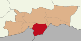
Silopi District
Silopi District | |
|---|---|
 Map showing Silopi District in Şırnak Province | |
| Coordinates: 37°16′N 42°30′E / 37.267°N 42.500°E | |
| Country | Turkey |
| Province | Şırnak |
| Seat | Silopi |
| Area | 831 km2 (321 sq mi) |
| Population (2023) | 148,126 |
| • Density | 180/km2 (460/sq mi) |
| Time zone | UTC+3 (TRT) |
Silopi District is a district of the Şırnak Province of Turkey.[1] The seat of the district is the town of Silopi and the population was 148,126 in 2023.[1][2] Its area is 831 km2.[3]
Settlements
[edit]Silopi District contains three beldes, thirty-three villages, of which seven are unpopulated, and moreover twenty-one hamlets.[1][4]
Municipalities
[edit]- Başverimli (Wehsid)
- Çalışkan (Gitê)
- Görümlü (Bêspin)
- Silopi
Villages
[edit]- Aksu (Herbol)
- Aktepe (Girê Gewre)
- Akyıldız (Babindak)
- Ballıkaya (Bilga)
- Başak (Zêdga)
- Birlikköy (Cumayî)
- Bostancı (Rihanî)
- Buğdaylı (Taqyan)
- Çardaklı (Kûlya)
- Çiftlikköy (Bedrû)
- Damlaca (Silib)
- Dedeler (Babika)
- Derebaşı (Girêçolya)
- Doruklu (Xezayî)
- Düzalan (Fêrikan)
- Esenli (Germkê)
- Kapılı (Kukît)
- Karacaköy (Sorbitmê)
- Kavaközü (Ribêyî)
- Kavallı (Nêrwan)
- Koyunören (Bêşer)
- Kösreli (Hesena)
- Mahmutlu
- Ortaköy (Gundhedît)
- Ovaköy (Korava)
- Özgen (Seletûn)
- Pınarönü (Eywan)
- Selçik (Derêdefş)
- Uyanık (Xinis)
- Üçağaç (Şivesor, Besta Belega)
- Yazıköy (Şemika)
- Yeniköy (Xirabreşik)
- Yolağzı (Girkûnda)
Population
[edit]Population history from 2007 to 2023:[2]
| Year | Pop. | ±% p.a. |
|---|---|---|
| 2007 | 96,690 | — |
| 2010 | 104,094 | +2.49% |
| 2015 | 121,463 | +3.13% |
| 2020 | 138,814 | +2.71% |
| 2023 | 148,126 | +2.19% |
References
[edit]- ^ a b c "Türkiye Mülki İdare Bölümleri Envanteri". T.C. İçişleri Bakanlığı (in Turkish). Retrieved 19 December 2022.
- ^ a b "Population Of Municipalities, Villages And Quarters". TÜİK. Retrieved 10 May 2024.
- ^ "İl ve İlçe Yüz ölçümleri". General Directorate of Mapping. Retrieved 1 March 2023.
- ^ Baz, Ibrahim (2016). Şırnak aşiretleri ve kültürü (in Turkish). p. 32. ISBN 9786058849631.
Text is available under the CC BY-SA 4.0 license; additional terms may apply.
Images, videos and audio are available under their respective licenses.


