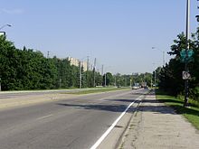
黑溪径
| 黑溪径 Black Creek Drive | |||||||
|---|---|---|---|---|---|---|---|
| 400 Extension | |||||||
| 道路信息 | |||||||
| 管理方 | 多伦多市政府 | ||||||
| 道路总长 | 3.5公里[1](2.2英里) | ||||||
| 启用时间 | 1982年 | ||||||
| 主要连接道路 | |||||||
| 南端 | 韦斯顿道 | ||||||
| 艾灵顿西路 Trethewey Drive 罗伦斯西路 | |||||||
| 北端 | (珍街) | ||||||
| 地点 | |||||||
| 主要城市 | 多伦多 | ||||||
| 公路系统 | |||||||
安大略省道路
| |||||||
黑溪径[2][3](英语:Black Creek Drive)是加拿大安大略省多伦多的一条四车道南北主向干道[4]。它通过400号省道将韦斯顿道及汉伯道(Humber Boulevard)与401号省道连接起来,后者形成了向南的延伸。黑溪径在珍街东南部的枫叶径(Maple Leaf Drive)行车天桥处正式过渡到400号省道。这条道路以黑溪峡谷命名,大部分路线与黑溪峡谷平行。限速为70千米每小时(43英里每小时)。作为市政道路,由多伦多警察队警员巡逻。
路线概述
[编辑]
黑溪径的南端始于多伦多丹尼士山社区的韦斯顿道夹汉伯道(Humber Boulevard)路口。这条四车道道路穿过GO运输基秦拿线及联合车站-皮尔逊机场快线铁路走廊的铁轨下方。道路沿黑溪向北行进,并由此得名。基理士杜公园(Keelesdale Park)位于东边。道路继续向西北偏北延伸,与艾灵顿西路相交。加冕公园(Coronation Park)及Trethewey Park 占据艾灵顿路以北道路的东侧,而西侧则用于商业及工业。[5]这片土地的大部分曾经是柯达工厂,如今仅以摄影径(Photography Drive)的存在为标志。[6]在Trethewey Drive与罗伦斯西路之间,黑溪径穿过黑溪峡谷内的住宅区。罗伦斯路以北,道路与黑溪峡谷分开。它与从头顶经过的皇后径(Queens Drive)和枫叶径(Maple Leaf Drive)在地面上是分开的。[5]
在枫叶径行车天桥处,黑溪径成为400号省道,此后路段归安大略省运输厅管辖。[7]该道路在夹摄影径、艾灵顿西路、Todd Bayliss Boulevard、Trethewey Drive及罗伦斯西路的交叉口设有信号灯。从Trethewey Drive以北,两个方向由混凝土屏障隔开,而从罗伦斯路以北,两个方向由一组钢护栏隔开。在Trethewey Drive以南,两个方向被草地中线隔开。[8]整个路线的限速为70 km/h(43 mph)。单车及行人禁止使用艾灵顿路以北的道路及铺砌的路肩。[9]
引用
[编辑]- ^ Google Inc. Black Creek Drive – Length and Route (地图). Google Inc. June 3, 2021 [June 3, 2021].
- ^ 明报加东版. 多市周四最塞車. www.mingpaocanada.com. [2023-08-13].
- ^ 明报新闻网海外版 - 加东版(多伦多) - Canada Toronto Chinese Newspaper - 要闻. 倡市府工程須聘年輕人 鄒至蕙盼創職5000份. www.mingpaocanada.com. [2023-08-13].
- ^ Transportation Services, City of Toronto 2008,第55页.
- ^ 5.0 5.1 Golden Horseshoe StreetFinder (地图). Cartography by Rand McNally. Allmaps Canada: 48. 1996.
- ^ Burley, Robert. The end of Photography Drive: A city landmark, and an industry, fade out. Globe and Mail. August 25, 2007 [June 3, 2021]. (原始内容存档于2023-08-14).
- ^ Ministry of Transportation of Ontario. Annual Average Daily Traffic (AADT) counts. 2016 [January 1, 2021]. (原始内容存档于2020-12-15).
- ^ Transportation Services, City of Toronto 2008,第33页.
- ^ Transportation Services. Black Creek Drive – Pedestrian Prohibited On Certain Highways: Amendments (PDF) (报告). City of Toronto. May 19, 2009 [January 26, 2021]. (原始内容存档 (PDF)于2023-08-14).
参考
[编辑]- Transportation Services. Road Classification System (PDF). City of Toronto. 2008 [June 6, 2021]. (原始内容存档 (PDF)于2023-05-21).
外部链接
[编辑]
| ||||||||||||||||||||||
Text is available under the CC BY-SA 4.0 license; additional terms may apply.
Images, videos and audio are available under their respective licenses.
