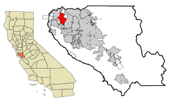
山景城
| 山景城 | |
|---|---|
| City of Mountain View | |
 | |
 山景城在加州和圣克拉拉县内位置 | |
| 坐标:37°23′34″N 122°02′31″W / 37.3928°N 122.0419°W | |
| 国家 | 美利坚合众国 |
| 州 | 加利福尼亚州 |
| 县 | 圣克拉拉县 |
| 市府成立 | 1902年11月7日[1] |
| 政府 | |
| • 类型 | 议会-经理制政府 |
| 面积[2] | |
| • 总计 | 12.24 平方英里(31.69 平方公里) |
| • 陆地 | 11.96 平方英里(30.97 平方公里) |
| • 水域 | 0.28 平方英里(0.72 平方公里) 2.26% |
| 海拔[3] | 105 英尺(32 米) |
| 人口(2020) | |
| • 总计 | 82,376人 |
| • 密度 | 6,730人/平方英里(2,599人/平方公里) |
| 时区 | PST(UTC-8) |
| • 夏时制 | PDT(UTC-7) |
| 网站 | www |
山景城(英语:Mountain View),或音译芒廷维尤[5],是美国加州圣克拉拉县内的一座城市,也是矽谷的主要组成部分,位于旧金山湾区西南部。总部位于这里的全球财富500强及全美财富1000强公司包括Google公司总部、赛门铁克、和Intuit。另外Mozilla基金会/Mozilla公司、微软的MSN、Hotmail、Xbox、MSN TV部门、SGI和埃姆斯研究中心等许多著名机构都位于该市。山景城还是美国第一座完全覆盖免费无线网络的城市。根据2010年美国人口普查,该市人口有74,066。
历史

山景城在十九世纪末期开始逐渐发展,当时是作为旧金山湾区中的一个驿站,服务于旧金山与圣荷西之间的驿站马车线路。随后于1902年11月7日正式建市,早期该市以发展农业为主,直到20世纪中叶,农业一直是该市的主要经济支柱。然而在第二次世界大战之后,该地成为矽谷发展的重点地区,大量航天工业及电子产业公司在此建立,人口也随之爆炸式增长。[6]从1950年到1960年,该市的人口从6,563迅猛增长到30,889,增幅达到370.7%。随后人口一直处于不断增长状态,科技代替农业成为该市的经济支柱,市内仅保留极少量农业用地。现今是为矽谷重镇,人口逾7万人。
地理

山景城位于85号加利福尼亚州州道北端,与101号美国国道交接处附近。历史性道路皇家大道也经过山景城。山景城在北边与帕罗奥多接壤,在西南边与洛思阿图斯接壤,在东南边与森尼维耳接壤,以及在东北边与旧金山湾接壤。也是圣荷西的卫星城之一。
根据美国人口普查局的资料,山景城的面积为31.7平方公里(12.2平方英里),其中31.2平方公里(12.1平方英里)是陆地、0.4平方公里(0.2平方英里)或1.39%的面积是水。山景城拥有旧金山湾区典型的地中海式气候,夏季炎热干燥,冬季温和多雨。
| 山景城 | |||||||||||||
|---|---|---|---|---|---|---|---|---|---|---|---|---|---|
| 月份 | 1月 | 2月 | 3月 | 4月 | 5月 | 6月 | 7月 | 8月 | 9月 | 10月 | 11月 | 12月 | 全年 |
| 历史最高温 °F(°C) | 77 (25) |
84 (29) |
85 (29) |
98 (37) |
100 (38) |
107 (42) |
105 (41) |
101 (38) |
105 (41) |
100 (38) |
89 (32) |
75 (24) |
107 (42) |
| 平均高温 °F(°C) | 59.0 (15.0) |
61.8 (16.6) |
65.0 (18.3) |
68.0 (20.0) |
71.7 (22.1) |
75.9 (24.4) |
76.9 (24.9) |
76.9 (24.9) |
77.7 (25.4) |
74.1 (23.4) |
65.5 (18.6) |
58.9 (14.9) |
69.3 (20.7) |
| 日均气温 °F(°C) | 50.7 (10.4) |
53.1 (11.7) |
55.8 (13.2) |
58.4 (14.7) |
62.1 (16.7) |
65.8 (18.8) |
67.7 (19.8) |
68.0 (20.0) |
67.5 (19.7) |
63.6 (17.6) |
55.9 (13.3) |
50.5 (10.3) |
59.9 (15.5) |
| 平均低温 °F(°C) | 42.2 (5.7) |
44.5 (6.9) |
46.7 (8.2) |
48.9 (9.4) |
52.5 (11.4) |
55.7 (13.2) |
58.5 (14.7) |
59.0 (15.0) |
57.3 (14.1) |
53.1 (11.7) |
46.3 (7.9) |
42.1 (5.6) |
50.6 (10.3) |
| 历史最低温 °F(°C) | 21 (−6) |
20 (−7) |
22 (−6) |
31 (−1) |
33 (1) |
40 (4) |
43 (6) |
44 (7) |
37 (3) |
34 (1) |
26 (−3) |
20 (−7) |
20 (−7) |
| 平均降水量 吋(mm) | 3.06 (78) |
3.31 (84) |
2.49 (63) |
0.98 (25) |
0.48 (12) |
0.09 (2.3) |
0 (0) |
0.03 (0.76) |
0.15 (3.8) |
0.76 (19) |
1.96 (50) |
2.95 (75) |
16.26 (412.86) |
| 平均降水天数 | 10 | 10.5 | 9.6 | 5.2 | 2.6 | 0.7 | 0.2 | 0.2 | 1.5 | 4.1 | 8.3 | 11.1 | 63.9 |
| 数据来源1:[7] | |||||||||||||
| 数据来源2:[8] | |||||||||||||
人口
| 历史人口数 | |||
|---|---|---|---|
| 调查年 | 人口 | %± | |
| 1910年 | 1,161 | — | |
| 1920年 | 1,888 | 62.6% | |
| 1930年 | 3,308 | 75.2% | |
| 1940年 | 3,946 | 19.3% | |
| 1950年 | 6,563 | 66.3% | |
| 1960年 | 30,889 | 370.7% | |
| 1970年 | 54,132 | 75.2% | |
| 1980年 | 58,655 | 8.4% | |
| 1990年 | 67,365 | 14.8% | |
| 2000年 | 70,708 | 5.0% | |
| 2010年 | 74,066 | 4.7% | |
| 2020年 | 82,376 | 11.2% | |
| source:[9] | |||
人口构成
根据2010年美国人口普查,2010年时,该市有74,066人,31,957户,17,515个家庭,33,881个住房单位。平均每个家庭有3.01人。种族构成为:56.0%的白人,26.0%亚裔,2.2%非洲裔,0.5%美洲原住民,0.5%太平洋岛屿居民,9.8%属于其它种族。5.1%同时来自两个或更多的种族。拉美裔约为21.7%。
2010年该市有27.3%的家庭拥有18岁以下的未成年人。43.2%为有异性婚姻的家庭,0.9%为同性恋同居。该市居民男女比例为103.6:100。
|
收入
根据2007年的估计,该市每户年收入中位数为$82,648美元。家庭年收入中位数为$105,079美元。有3.6%的家庭和6.8%的人口收入位于贫困线以下,包括7.2%的未成年人和5.9%的65岁以上老年人。[11]
交通
参考文献
- ^ 山景城百年慶 - 山景城政府(英). [2007-02-11]. (原始内容存档于2006-11-17).
- ^ 2019 U.S. Gazetteer Files. United States Census Bureau. [July 1, 2020]. (原始内容存档于2020-01-16).
- ^ Mountain View. Geographic Names Information System. United States Geological Survey. [October 13, 2014].
- ^ Population and Housing Unit Estimates. United States Census Bureau. May 24, 2020 [May 27, 2020]. (原始内容存档于2020-08-14).
- ^ 民政部地名研究所 (编). Mountain View 芒廷维尤. 世界地名译名词典. 北京: 中国社会出版社: 1876. 2017-05. ISBN 978-7-5087-5525-0. OCLC 1121629943. OL 28272719M. NLC 009152391.(简体中文)
- ^ City of Mountain View - Learn About Our City. [2011-03-15]. (原始内容存档于2011-03-26).
- ^ Mountain View, California Monthly Weather. The Weather Channel. [January 29, 2018]. (原始内容存档于2019-12-04).
- ^ Summary of Monthly Normals 1991-2020. NOAA. [June 29, 2021]. (原始内容存档于2023-07-31).
- ^ Census of Population and Housing - Decennial Censuses. United States Census Bureau. [2011-02-01]. (原始内容存档于2006-02-08).
- ^ Demographic Profile Bay Area Census. [2020-10-08]. (原始内容存档于2016-01-02).
- ^ 存档副本. [2012-10-04]. (原始内容存档于2020-02-11).
| |||||||||||||||||||||||||||||||||||
| |||||||||||||||||||||||||||||||||||||||||||||||||
| |||||||||||||||||
Text is available under the CC BY-SA 4.0 license; additional terms may apply.
Images, videos and audio are available under their respective licenses.


