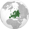
For faster navigation, this Iframe is preloading the Wikiwand page for 塞尔维亚地理.

塞尔维亚地理

联合国的塞尔维亚地图
2006年CIA世界概况中的地图

塞尔维亚是位于巴尔干半岛的内陆国。和波斯尼亚和黑塞哥维那保加利亚克罗地亚匈牙利马其顿共和国黑山罗马尼亚接壤。塞尔维亚境内的科索沃在2008年宣布独立,但并未得到广泛的承认[注 1]。塞尔维亚虽然是内陆国,仍可通过黑山至亚得里亚海,及通过多瑙河至欧洲内地和黑海。塞尔维亚的国土面积是88,361平方公里。塞尔维亚北部地区地形平坦,而南部则地势较高。塞尔维亚大多数地区气候温和。

注释

  1. ^ 科索沃是一个在科索沃共和国塞尔维亚共和国之间的争议领土。科索沃已于2008年单方面宣布独立并成立了科索沃共和国,但塞尔维亚仍坚持认为科索沃是其主权领土的一个自治区联合国193个成员国中有113个已承认科索沃的独立地位。

参考文献

外部链接

{{bottomLinkPreText}} {{bottomLinkText}}
塞尔维亚地理
Listen to this article

This browser is not supported by Wikiwand :(
Wikiwand requires a browser with modern capabilities in order to provide you with the best reading experience.
Please download and use one of the following browsers:

This article was just edited, click to reload
This article has been deleted on Wikipedia (Why?)

Back to homepage

Please click Add in the dialog above
Please click Allow in the top-left corner,
then click Install Now in the dialog
Please click Open in the download dialog,
then click Install
Please click the "Downloads" icon in the Safari toolbar, open the first download in the list,
then click Install
{{::$root.activation.text}}

Install Wikiwand

Install on Chrome Install on Firefox
Don't forget to rate us

Tell your friends about Wikiwand!

Gmail Facebook Twitter Link

Enjoying Wikiwand?

Tell your friends and spread the love:
Share on Gmail Share on Facebook Share on Twitter Share on Buffer

Our magic isn't perfect

You can help our automatic cover photo selection by reporting an unsuitable photo.

This photo is visually disturbing This photo is not a good choice

Thank you for helping!


Your input will affect cover photo selection, along with input from other users.

X

Get ready for Wikiwand 2.0 🎉! the new version arrives on September 1st! Don't want to wait?