پاکستان کا خاکہ


مندرجہ ذیل خاکہ پاکستان کا جائزہ پیش کرتا ہے:
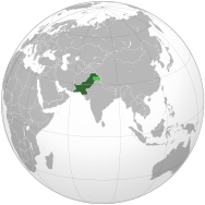
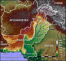
پاکستان – ایک خود مختار ریاست ہے جو جنوبی ایشیا میں واقع ہے۔[1] اس کی 1,046 کلومیٹر (3,432,000 فٹ) طویل سرحد جنوب میں بحیرہ عرب اور خلیج عمان کے ساتھ ساتھ ساحلی پٹی ہے اور مغرب میں افغانستان، جنوب مغرب میں ایران، مشرق میں بھارت اور شمال مشرق میں چین سے لگتی ہیں۔[2]
عمومی حوالہ
[ترمیم]
- بین الاقوامی صوتیاتی ابجد:
- ملک کا عام فہم نام: پاکستان
- سرکاری نام: اسلامی جمہوریہ پاکستان
- صفاتی: پاکستانی
- اشتقاقیات: پاکستان کے نام
- پاکستان کی بین الاقوامی درجہ بندی
- آیزو 3166-1: PK, PAK, 586
- آیزو 3166-2: دیکھیے آیزو 3166-2:PK
- انٹرنیٹ بلند ترین ڈومین نیم برائے ممالک: Pk.
جغرافیہ پاکستان
[ترمیم]
- پاکستان: ایک قومی ریاست ہے
- محل وقوع:
- شمالی نصف کرہ اور مشرقی نصف کرہ
- یوریشیا
- منطقۂ وقت: پاکستان کا معیاری وقت UTC+05، پاکستان کا معیاری وقت UTC+06
- پاکستان کے انتہائی مقامات
- زمین کی حدود: 6,774 کلومیٹر
 بھارت (بشمول متنازع لائن آف کنٹرول 2,912 کلومیٹر)
 افغانستان 2,430 کلومیٹر
 ایران 909 کلومیٹر
- ساحل: بحیرہ عرب 1,046 کلومیٹر
- آبادیات پاکستان:
- جغرافیہ پاکستان: 803,940 کلومیٹر2
- پاکستان کے نقشے
پاکستان کا خاکہ
[ترمیم]
|

| |||
| بحیرہ عرب خلیج فارس |
پاکستان کا ماحول
[ترمیم]
Environment of Pakistan
- پاکستان کی آب و ہوا
- Environmental issues in Pakistan
- Ecoregions in Pakistan
- Renewable energy in Pakistan
- Geology of Pakistan
- پاکستان کی محفوظ شدہ علاقے
- Biosphere reserves of Pakistan
- فہرست پاکستانی قومی پارک
- پاکستان میں جنگلاتی حیات
- نباتاتیہ پاکستان
- حیوانیہ پاکستان
- پاکستان کے پرندوں کی فہرست
- Mammals of Pakistan
- Fish of Pakistan
- Amphibians of Pakistan
- Reptiles of Pakistan
پاکستان کے قدرتی جغرافیائی خصوصیات
[ترمیم]- پاکستانی گلشیروں کی فہرست
- فہرست جزائر پاکستان
- فہرست پاکستان کی جھیلیں
- فہرست پاکستان کے پہاڑ
- Volcanoes in Pakistan
- فہرست پاکستان کے دریا
- پاکستانی وادیوں کی فہرست
- فہرست پاکستان کے مقامات عالمی ثقافتی ورثہ
پاکستان کی انتظامی تقسیم
[ترمیم]پاکستان کے صوبے
[ترمیم]پاکستان کے اضلاع
[ترمیم]پاکستان کے شہر و بلدیات
[ترمیم]پاکستان کی آبادیات
[ترمیم]حکومت اور پاکستان کی سیاست
[ترمیم]پاکستان کے خارجہ تعلقات
[ترمیم]بین الاقوامی تنظیموں کی رکنیت
[ترمیم]اسلامی جمہوریہ پاکستان ان تنظیموں کا رکن ہے:[1]
|
|
پاکستان میں امن و امان
[ترمیم]- پاکستان میں سزائے موت
- آئین پاکستان
- پاکستان میں جرائم
- پاکستان میں انسانی حقوق
- پاکستان میں ایل جی بی ٹی حقوق
- پاکستان میں مذہب کی آزادی
- نفاذ قانون کے ادارے
پاکستانی مسلح افواج
[ترمیم]- کمانڈ
- افواج
- پاکستان کی فوجی تاریخ
پاکستان میں مقامی حکومت
[ترمیم]تاریخ پاکستان
[ترمیم]- پاکستان کی معاشی تاریخ
- پاکستان کی فوجی تاریخ
پاکستان کی ثقافت
[ترمیم]- پاکستانی فن تعمیر
- پاکستانی پکوان
- پاکستان میں نسلی اقلیتیں
- پاکستان کی زبانیں
- پاکستانی میڈیا
- پاکستان کی قومی علامتیں
- پاکستانی قوم
- پاکستان میں عصمت فروشی
- تعطیلات پاکستان
- پاکستان میں مذہب
- فہرست پاکستان کے مقامات عالمی ثقافتی ورثہ
- بلوچ قبائل
- پنجابی قبائل
- خیبر پختونخوا
- بلوچستان میں قبائل
- سندھی لوگ
- Bhil
- Kolhi
- Maghwar
- Gurgala
- سرائیکی[ضدابہام درکار]
- سامی- ناروے کے قدیم باشندے
- Saniasi
- Wartia
- Khati
- Kocharra
- Kunbhar
- Ravarra
- Kabotaria
- Jogi (snake charmer)
- Jogi (Marwari)
- Burraha
- Gurarro
- Muhanna
- Bagari
- Bhangi
- Hadwarr
- Guaria
- Rabari
- Charan
- Sati
- Oad
- Balishai
- Lohar
- Tribes in Gilgit-Baltistan
پاکستان میں فن
[ترمیم]- پاکستانی سنیما
- پاکستانی ادب
- پاکستانی موسیقی
- پاکستان میں ٹیلی ویژن
- پاکستان میں تھیٹر
پاکستان میں کھیل
[ترمیم]- پاکستان میں ہاکی
- پاکستان میں کرکٹ
- پاکستان میں پولو
- پاکستان میں فٹ بال
- پاکستان اولمپکس میں
معیشت اور پاکستان کے بنیادی ڈھانچے
[ترمیم]- اقتصادی درجہ، بلحاط نام جی ڈی پی (2009):چوالیسواں
- پاکستان میں زراعت
- پاکستان میں بینکاری
- پاکستان میں مواصلات
- پاکستان میں انٹرنیٹ
- پاکستان کے کاروباری اداروں کی فہرست
- کاغذی کرنسی: پاکستانی روپیہ
- پاکستان کی معاشی تاریخ
- پاکستان میں توانائی
- پاکستان کی توانائی پالیسی
- پاکستان میں آئل صنعت
- پاکستان میں صحت کی دیکھ بھال
- پاکستان میں کاکنی
- پاکستان سٹاک ایکسچینج
- پاکستان میں سیاحت
- پاکستان میں ذرائع نقل و حمل
- پانی کی فراہمی اور پاکستان میں صحت و صفائی
پاکستان میں تعلیم
[ترمیم]مزید دیکھیے
[ترمیم]| ویکیپیڈیا، آزاد دائرۃ المعارف اردو زبان میں |
| ویکیپیڈیا، آزاد دائرۃ المعارف مغربی پنجابی میں |
| ویکیپیڈیا، آزاد دائرۃ المعارف سندھی زبان میں |
| ویکیپیڈیا، آزاد دائرۃ المعارف پشتو زبان میں |
| ویکیپیڈیا، آزاد دائرۃ المعارف کشمیری زبان میں |
| ویکیپیڈیا، آزاد دائرۃ المعارف انگریزی زبان میں |
- سندھ
- فہرست متعلقہ مضامین پاکستان
- فہرست بین الاقوامی درجہ بندی
- پاکستان متعلقہ موضوعات کی فہرست
- دولت مشترکہ کے رکن ممالک
- اقوام متحدہ کے رکن ممالک
- ایشیا کا خاکہ
- جغرافیہ کا خاکہ
حوالہ جات
[ترمیم]- ^ ا ب "پاکستان"۔ کتاب حقائق عالم۔ ریاستہائے متحدہ امریکا سی آئی اے۔ جولائی 2, 2009۔ 26 دسمبر 2018 میں اصل سے آرکائیو شدہ۔ اخذ شدہ بتاریخ جولائی 23، 2009
- ↑ The entire کشمیر region is claimed by Pakistan, including جموں و کشمیر۔ China also administers part of the region with the Indian and Pakistani-held areas defined by the لائن آف کنٹرول۔Pakistan refers to Jammu and Kashmir as "Indian-Occupied Kashmir"۔
بیرونی روابط
[ترمیم]| Pakistan کے بارے میں مزید جاننے کے لیے ویکیپیڈیا کے ساتھی منصوبے: | |
| لغت و مخزن ویکی لغت سے | |
| انبارِ مشترکہ ذرائع ویکی ذخائر سے | |
| آزاد تعلیمی مواد و مصروفیات ویکی جامعہ سے | |
| آزاد متن خبریں ویکی اخبار سے | |
| مجموعۂ اقتباساتِ متنوع ویکی اقتباسات سے | |
| آزاد دارالکتب ویکی ماخذ سے | |
| آزاد نصابی و دستی کتب ویکی کتب سے | |
- Government of Pakistan
- The President of Pakistanآرکائیو شدہ (Date missing) بذریعہ presidentofpakistan.gov.pk (Error: unknown archive URL)
- The Ministry of Information and Broadcastingآرکائیو شدہ (Date missing) بذریعہ infopak.gov.pk (Error: unknown archive URL)
 Pakistan سفری معلومات ویکی سفر پر
- کرلی (ڈی موز پر مبنی) پر پاکستان کا خاکہ
Text is available under the CC BY-SA 4.0 license; additional terms may apply.
Images, videos and audio are available under their respective licenses.


