国道254号
| 一般国道 | |
|---|---|
 | |
| 国道254号 | |
| 地図 | |

| |
| 総延長 | 278.6 km |
| 実延長 | 251.9 km |
| 現道 | 202.1 km |
| 制定年 | 1963年(昭和38年)[1] |
| 起点 | 東京都文京区[1] 本郷三丁目交差点(北緯35度42分27.03秒 東経139度45分38.09秒 / 北緯35.7075083度 東経139.7605806度) |
| 主な 経由都市 |
東京都文京区・豊島区・板橋区・練馬区 埼玉県和光市・朝霞市・新座市・富士見市・ふじみ野市・川越市・東松山市・深谷市・本庄市 群馬県藤岡市・富岡市 長野県佐久市・上田市・松本市 |
| 終点 | 長野県松本市[1] 平瀬口交差点(北緯36度15分57.08秒 東経137度56分41.22秒 / 北緯36.2658556度 東経137.9447833度) |
| 接続する 主な道路 (記法) |
|
| ■テンプレート(■ノート ■使い方) ■PJ道路 | |
概要
東京都心と埼玉県西部を結ぶ道路という事もあり、渋滞が激しいこの道は古くから川越街道 - 児玉街道 - 富岡街道 - 信州街道として「江戸道」「川越道」などとも呼ばれた。中山道より行程距離も短く、通行者も多かったため、五街道に準ずる脇往還として宿駅整備された(川越児玉往還)。大名などが多く利用する五街道とは違い、役人や女性が多く利用していた事から群馬県甘楽郡下仁田町のように「姫街道」と呼んでいる地域もある[2]。長野県の一部区間は中山道となっている。
東京都文京区の国道254号起点から群馬県藤岡市まで国道17号・関越自動車道にほぼ並行しており、藤岡市から長野県佐久市までの間では上信越自動車道にほぼ並行している。
山手線内側では春日通り、山手線外側や埼玉県では川越街道、群馬県内では信州街道などと呼ばれている。
路線データ
一般国道の路線を指定する政令[3][注釈 1]に基づく起終点および重要な経過地は次のとおり。
- 起点:東京都文京区(本郷三丁目交差点 = 国道17号交点)
- 終点:松本市(平瀬口交差点 = 国道19号交点、国道147号終点)
- 重要な経過地:東京都豊島区(池袋一丁目)、同都板橋区(上板橋一丁目)、同都練馬区、和光市、朝霞市、新座市、富士見市、川越市、埼玉県比企郡川島町、東松山市、同県大里郡寄居町、同県児玉郡児玉町、藤岡市(藤岡)、富岡市、佐久市[注釈 2]、長野県北佐久郡立科町、同県小県郡長門町[注釈 3]、同郡丸子町[注釈 4]
- 総延長:278.6 km(群馬県 76.3 km、埼玉県 111.2 km、東京都 15.2 km、長野県 75.9 km)重用延長を含む[4][注釈 5]
- 重用延長:26.7 km(群馬県 - km、埼玉県 5.6 km、東京都 - km、長野県 21.1 km)[4][注釈 5]
- 未供用延長:なし[4][注釈 5]
- 実延長:251.9 km(群馬県 76.3 km、埼玉県 105.6 km、東京都 15.2 km、長野県 54.8 km)[4][注釈 5]
- 指定区間:東京都文京区本郷二丁目306番27 - 同都練馬区旭町三丁目564番1(本郷三丁目交差点(起点) - 埼玉県境)、川越市新宿町二丁19番の1 - 同市大字大仙波字弁天前328番の1(国道16号と重複する区間:川越市新宿町 - 川越市大仙波)[5]
歴史
群馬県甘楽郡下仁田町南野牧から長野県佐久市に至る内山峠の箇所の旧道は急勾配で道幅も狭く、九十九折であったことも相まって、転落事故も多かった[注釈 6]。しかし、旧道時代においても長野県へと抜ける道路として普通車をはじめ、大型貨物自動車も頻繁に利用していた。その後、1978年(昭和53年)には県境の内山トンネルが開通、1989年(平成元年)に内山道路(現道)が全線開通したため、その利便性が大幅に改善され、ほとんどの車両はそちらを利用するようになった。同時に、交通量も増大した。
長野県内では、上田市と松本市を結び長らく有料道路であった三才山トンネル有料道路・松本トンネル有料道路が2020年(令和2年)に無料化された[6]。
年表
- 1963年(昭和38年)4月1日 - 二級国道東京小諸線(東京都文京区 - 長野県佐久市 - 長野県小諸市)として指定。佐久市 - 小諸市は国道141号と重複。
- 1965年(昭和40年)4月1日 - 一般国道254号となる。
- 1970年(昭和45年)4月1日 - 長野県佐久市 - 長野県松本市の区間(主要地方道松本佐久線)を編入し、総区間は東京都文京区 - 長野県松本市となる。
- 1971年(昭和46年)12月20日 - 一般国道254号東京川越道路として練馬IC - 川越ICが開通。
- 1973年(昭和48年)4月1日 - 東京川越道路が高速自動車国道の関越自動車道に編入される。
- 1976年(昭和51年)10月31日 - 長野県上田市 - 松本市間の三才山トンネル有料道路供用開始。
- 1977年(昭和52年) - 埼玉県東松山市 - 比企郡嵐山町間の嵐山バイパス全通。
- 1978年(昭和53年) - 群馬県甘楽郡下仁田町 - 長野県佐久市県境部の内山隧道開通。
- 1981年(昭和56年)8月1日 - 富士見川越有料道路全通。
- 1986年(昭和61年) - 埼玉県比企郡川島町 - 東松山市間の川島バイパス全通。
- 1989年(平成元年)8月9日 - 群馬県甘楽郡下仁田町 - 長野県佐久市間の内山道路全通。
- 1991年(平成3年) - 埼玉県比企郡小川町の小川バイパス全通。
- 1994年(平成6年)12月15日 - 長野県松本市の松本トンネル有料道路供用開始。
- 1997年(平成9年) - 埼玉県東松山市の東松山バイパス全通。
- 2000年(平成12年) - 群馬県甘楽郡甘楽町 - 富岡市間の富岡バイパス全通。
- 2005年(平成17年)12月22日 - 長野県佐久市内の平賀バイパスが全通。
- 2007年(平成19年)3月25日 - 東松山市内の旧道区間指定解除。
- 2009年(平成21年)8月1日 - 富士見川越有料道路無料開放。
- 2011年(平成23年)9月13日 - 埼玉県児玉郡美里町の猪俣バイパス開通。
- 2019年(令和元年)
- 2020年(令和2年)9月1日 - 三才山トンネル有料道路[6]・松本トンネル有料道路無料開放[8]。長野県上田市内の平井バイパス一部開通[9]。
高速自動車国道に編入された区間
路線状況
200 kmを越える長大な路線のなかには、東京都心の春日通りなどに見られる大通りから、山間部のセンターラインの無い狭い道路まであり、また、三才山を貫く長大なトンネルも施設されているなど、道路の状況は変化に富む[12]。
通称
- 春日通り(東京都文京区 本郷三丁目交差点 - 豊島区 池袋六ツ又交差点)[13][14]。
- 川越街道(東京都豊島区 池袋六ツ又交差点 - 埼玉県川越市 新宿町(北)交差点)[13][14][1]
- 川越児玉往還(江戸道、川越道)
- 信州街道
- 富岡街道
- 西上州やまびこ街道(群馬県西部区間)
- コスモス街道(内山峠 - 長野県佐久市中込)
- 松本街道
- 中山道(国道142号重用区間)
バイパス
- 和光バイパス - 事業中
- 和光富士見バイパス - 一部開通(東京外環自動車道から約 2.6km)
- 新座バイパス
- 浦和所沢バイパス(国道463号本線との重複区間)
- 富士見川越バイパス
- 川越バイパス
- 川島バイパス
- 東松山バイパス
- 唐子バイパス
- 嵐山バイパス
- 小川バイパス
- 猪俣バイパス
- 児玉バイパス
- 藤岡バイパス
- 甘楽吉井バイパス
- 富岡バイパス
- 下仁田バイパス
- 平賀バイパス
- 宇山バイパス
- 和子バイパス
- 平井バイパス
- 三才山トンネル有料道路
- 松本トンネル有料道路
※「浦和所沢バイパス」という名称は、かつて存在した埼玉県道2号浦和所沢線のバイパスを意味するもので、同バイパスのうち当国道のバイパスでもある区間は新座市の英ICから富士見市の下南畑交差点までで、当国道は浦和地区や所沢市は通っていない。
重複区間
- 国道463号(埼玉県新座市英IC - 富士見市下南畑)
- 国道16号(埼玉県川越市新宿町 - 川越市大仙波)
- 国道140号(埼玉県大里郡寄居町桜沢)
- 国道142号(長野県佐久市・跡部交差点 - 北佐久郡立科町宇山)
- 国道152号(長野県小県郡長和町古町 - 上田市腰越)
道路施設
主な橋梁
- 落合橋(入間川・小畔川・越辺川、埼玉県川越市 - 比企郡川島町)
- 玉淀大橋(荒川、埼玉県大里郡寄居町)
- 藤武橋(神流川、埼玉県児玉郡上里町 - 群馬県藤岡市小林)
- 富岡大橋(鏑川、群馬県富岡市)
- 新富岡大橋(鏑川、群馬県富岡市)※富岡バイパス
- 比佐理橋(鏑川、群馬県富岡市 - 群馬県甘楽郡下仁田町)
- 内山大橋(滑津川、長野県佐久市)
- 佐久大橋(千曲川、長野県佐久市)
- 南角大橋(南角沢、長野県上田市)
- 鹿教湯大橋(広河原、長野県上田市)
主なトンネル
- 金勝山トンネル(埼玉県比企郡小川町)
- 平畠トンネル(群馬県甘楽郡下仁田町)
- 高梨子トンネル(群馬県甘楽郡下仁田町)
- 内山トンネル(群馬県甘楽郡下仁田町 - 長野県佐久市)
- 小屋坂トンネル(長野県上田市)
- 鹿教湯トンネル(長野県上田市)
- 笠岩トンネル(長野県上田市)
- 孫六トンネル(長野県上田市)
- 三才山トンネル(長野県上田市 - 長野県松本市)
- 松本トンネル(長野県松本市)
道の駅
- 埼玉県
- おがわまち(比企郡小川町)
- 群馬県
- しもにた(甘楽郡下仁田町)
- 長野県
- ほっとぱ〜く・浅科(佐久市)
- ヘルシーテラス佐久南(佐久市)
- 女神の里たてしな(北佐久郡立科町)
地理
通過する自治体
交差する道路
- 東京都
- 国道17号(本郷通り)・東京都道453号本郷亀戸線(春日通り)(文京区・本郷三丁目交差点)
- 東京都道301号白山祝田田町線(白山通り)(文京区・春日町交差点)
- 明治通り(東京都道305号芝新宿王子線)(豊島区・六又陸橋交差点)
- 首都高速5号池袋線北池袋出入口 - (豊島区・板橋区境付近)
- 山手通り(東京都道317号環状六号線)(板橋区・熊野町交差点)
- 環七通り(東京都道318号環状七号線)(板橋区・板橋中央陸橋)
- 環八通り(東京都道311号環状八号線)(練馬区・練馬北町陸橋)
- 国道17号(新大宮バイパス、練馬区)
- 埼玉県
- 群馬県
- 上信越自動車道 - (甘楽郡下仁田町)
- 長野県
並行する鉄道路線
明治期には、東京から群馬県渋川市を経て、新潟県長岡市までの鉄道路線として計画された東上鉄道(現在の東武東上線)の当時の敷設計画ルートも、群馬県藤岡市までほぼこの道に並行している。
ギャラリー
-
-
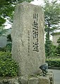
 本郷三丁目交差点。写真左下が国道254号(2018年10月)
 -
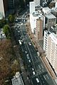 文京シビックセンターから見た国道254号(2011年12月)
 -
 新座貨物ターミナル駅付近(2014年8月)
 -
 埼玉県新座市英インターチェンジ(2014年8月)
 -
 埼玉県ふじみ野市大井付近(2014年8月)
 -
 埼玉県ふじみ野市付近(2009年10月)
 -
 埼玉県川越市落合橋付近(2014年8月)
 -
-
 埼玉県東松山市下野本交差点(2021年8月)
 -
 埼玉県比企郡小川町旧道上り方面(2012年11月)
 -

-

-
 内山トンネル付近(2013年4月)
 -
 三才山トンネル松本方坑口(2008年10月)
 -


脚注
注釈
出典
- ^ a b c d 和光市民なら知っておきたい川越街道の真実 Archived 2016年3月4日, at the Wayback Machine.和光市
- ^ 静かに時を刻む宿場町 Archived 2007年12月23日, at the Wayback Machine.、群馬県、2007年10月26日。
- ^ “一般国道の路線を指定する政令(昭和40年3月29日政令第58号)”. e-Gov法令検索. 総務省行政管理局. 2021年9月20日閲覧。
- ^ a b c d e f g “表26 一般国道の路線別、都道府県別道路現況” (XLS). 道路統計年報2023. 国土交通省道路局. 2024年4月15日閲覧。
- ^ “一般国道の指定区間を指定する政令(昭和33年6月2日政令第164号)”. e-Gov法令検索. 総務省行政管理局. 2012年10月26日閲覧。
- ^ a b 長野県報令和2年8月31日第135号p.2
- ^ 長野県報令和元年7月4日第18号p.4、長野県(上田建設事務所)プレスリリース
- ^ 長野県(上田建設事務所)プレスリリース
- ^ 長野県報令和2年8月31日第135号p.2、長野県(上田建設事務所)プレスリリース
- ^ 佐藤健太郎 2014, p. 46.
- ^ 浅井建爾 2015, pp. 91–92.
- ^ 佐藤健太郎 2014, p. 110.
- ^ a b 東京都通称道路名一覧表 Archived 2016年3月5日, at the Wayback Machine.東京都建設局
- ^ a b 東京都通称道路名地図(区部拡大版) Archived 2016年3月5日, at the Wayback Machine.東京都建設局
参考文献
- 浅井建爾『日本の道路がわかる辞典』(初版)日本実業出版社、2015年10月10日。ISBN 978-4-534-05318-3。
- 佐藤健太郎『ふしぎな国道』講談社〈講談社現代新書〉、2014年。ISBN 978-4-06-288282-8。
関連項目
- 新座洞道火災事故 - 2016年、国道と並行する高圧送電ケーブルが火災となり一時通行止めになった。
外部リンク
- 国土交通省関東地方整備局
- 埼玉県 県土整備部
- 朝霞県土整備事務所 :和光市 - 新座市、志木市(富士見川越バイパス)の区間を管理。
- 川越県土整備事務所:入間郡三芳町 - 川越市の指定区間外(富士見川越バイパスを含む)を管理。
- 東松山県土整備事務所:比企郡川島町 - 比企郡小川町の区間(小川バイパスを含む)を管理。
- 熊谷県土整備事務所:大里郡寄居町、深谷市の区間を管理。
- 本庄県土整備事務所:児玉郡美里町 - 児玉郡上里町の区間を管理。
- 群馬県県土整備部 道路管理課
- 長野県建設部 道路管理課
- 佐久建設事務所佐久北部事務所:佐久市 - 北佐久郡立科町の区間を管理。
- 上田建設事務所:小県郡長和町 - 上田市の区間を管理。
- 松本建設事務所:松本市内の区間を管理。
| 交差点 | |
|---|---|
| バイパス | |
| 道路名・愛称 | |
| 道の駅 | |
| 主要構造物 | |
| 自然要衝 | |
| 旧道 | |
| 関連事項 | |
Text is available under the CC BY-SA 4.0 license; additional terms may apply.
Images, videos and audio are available under their respective licenses.
