考利县 (堪萨斯州)
| 考利县 Cowley County | |
|---|---|
| 县 | |
 国家银行建筑 | |
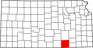
 考利县于堪萨斯州中的位置 | |
 堪萨斯州于美国的位置 | |
| 坐标:37°14′N 96°50′W / 37.233°N 96.833°W | |
| 国家 | |
| 州 | |
| 设立日期 | 1867年2月26日 |
| 语源 | 马修·考利 |
| 县治 | 温菲尔德 |
| 最大城市 | 阿肯色城 |
| 面积 | |
| • 总计 | 1,132 平方英里(3,000 平方公里) |
| • 陆地 | 1,126 平方英里(3,000 平方公里) |
| • 水域 | 6.7 平方英里(20 平方公里) 0.6%% |
| 人口(2020年)[1] | |
| • 总计 | 34,549人 |
| • 密度 | 30.7人/平方英里(11.9人/平方公里) |
| 时区 | 中部时区(UTC−6) |
| • 夏时制 | 中部时区(UTC−5) |
| 电话区号 | 620 |
| 包含的国会选区 | 第四国会选区 |
| 网站 | cowleycounty.org |
考利县(英语:Cowley County,县份代码CL)是美国堪萨斯州东南部的一个县,南邻俄克拉荷马州,面积2,933平方公里。根据2010年人口普查,本县共有人口34,549人[1]。本县县治为温菲尔德,最大城市为阿肯色城。
历史

几千年来,堪萨斯州都是印第安人的聚居地。于1537年,探险家德索托成为了到达这一带的首位欧洲人。[2]于1803年,联邦政府透过路易西安纳购地案购买了包括堪萨斯州在内的一大片土地。堪萨斯领地于1854年成立,而堪萨斯州则于1861年成立。
本县于1867年2月26日成立,而县政府则于1870年成立。起初,本县名为亨特县,取名自弗吉尼亚州国会代表、参议员和众议院议长罗伯特·默瑟·托利弗·亨特(Robert Mercer Taliaferro Hunter)。于1867年3月,堪萨斯立法机关便将本县纳入欧塞奇印第安人的领地内。于1870年,本县更名为考利县,取自在美国内战中阵亡的中尉马修·考利 (Matthew Cowley)[3]
在县政府成立后,温菲尔德和克雷斯韦尔(现名阿肯色市)竞争成为县治。经过两次特殊投票和多次请愿后,县政府决定将温菲尔德定为县治,并于1873年在温菲尔德建立县法院。[4]
地理
根据2000年人口普查,考利县的总面积为1,132.60平方英里(2,933.4平方千米),其中有1,126.24平方英里(2,916.9平方千米),即99.44%为陆地;6.37平方英里(16.5平方千米),即0.56%为水域。[5]
毗邻县
人口
| 历史人口数 | |||
|---|---|---|---|
| 调查年 | 人口 | %± | |
| 1860年 | 158 | — | |
| 1870年 | 1,175 | 643.7% | |
| 1880年 | 21,538 | 1,733.0% | |
| 1890年 | 34,478 | 60.1% | |
| 1900年 | 30,156 | −12.5% | |
| 1910年 | 31,790 | 5.4% | |
| 1920年 | 35,155 | 10.6% | |
| 1930年 | 40,903 | 16.4% | |
| 1940年 | 38,139 | −6.8% | |
| 1950年 | 36,905 | −3.2% | |
| 1960年 | 37,861 | 2.6% | |
| 1970年 | 35,012 | −7.5% | |
| 1980年 | 36,824 | 5.2% | |
| 1990年 | 36,915 | 0.2% | |
| 2000年 | 36,291 | −1.7% | |
| 2010年 | 36,311 | 0.1% | |
| 2012年估计 | 36,288 | −0.1% | |
2012年人口估计[7] | |||

根据2000年人口普查[8],考利县拥有36,291居民、14,039住户和9,616家庭。[9]其人口密度为每平方英里32居民(每平方公里12居民)。[10]本县拥有15,673间房屋单位,其密度为每平方英里14间(每平方公里5间)。[11]而人口是由90.13%白人、2.7%黑人、1.96%土著、1.53%亚洲人、0.01%太平洋白民、1.36%其他种族和2.3%混血构成。而西班牙裔或拉丁美洲人占了人口3.59%。[12]
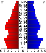
在14,039住户中,有32.2%拥有一个或以上的儿童(18岁以下)、55.2%为夫妻、9.6%为单亲家庭、31.5%为非家庭、27.9%为独居、13.2%住户有同居长者。平均每户有2.46人,而平均每个家庭则有3人。在36,291居民中,有26%为18岁以下、9.9%为18至24岁、26%为25至44岁、22.2%为45至65岁以及15.9%为65岁以上。人口的年龄中位数为37岁,女子对男子的性别比为100:95.7。成年人的性别比则为100:94.2。[13]
本县的住户收入中位数为$34,406,而家庭收入中位数则为$43,636。男性的收入中位数为$31,703,而女性的收入中位数则为$21,341,人均收入为$17,509。约9.2%家庭和12.9%人口在贫穷线以下,包括17%儿童(18岁以下)及11.2%长者(65岁以上)。[13]
教育
联合学区
- 中央联合学区 (页面存档备份,存于互联网档案馆)(第462联合学区)
- 尤德尔联合学区 (页面存档备份,存于互联网档案馆)(第463联合学区)
- 温菲尔德联合学区 (页面存档备份,存于互联网档案馆)(第465联合学区)
- 阿肯色城联合学区 (页面存档备份,存于互联网档案馆)(第470联合学区)
- 德克斯特联合学区 (页面存档备份,存于互联网档案馆)(第471联合学区)
大学
- 考利大学
- 西南大学
- 圣约翰斯大学(已于1986年停办)
行政区划

城市
非建制地区
镇区
考利县下分25个镇区。下表列出了考利县辖下之镇区,其中包含各镇区之相关资料。
参见
- 堪萨斯州考利县国家史迹名录列表
参考文献
- ^ 1.0 1.1 QuickFacts; Cowley County, Kansas; Population, Census, 2020 & 2010. United States Census Bureau. [2021-08-15]. (原始内容存档于2021-08-15).
- ^ D. A. Millington and E. P. Greer, ”History of Cowley County Kansas”., Winfield Courier, January 1, 1901 Supplement
- ^ Kane, J. N. and C. C. Aiken. The American Counties: Origins of County Names Dates of Creation and Population Data 1950-2000. Lanham, MD.: Scarecrow Press, 2005.
- ^ William G. Cutler's, History of the State of Kansas. A. T. Andreas Press, 1883.[永久失效链接]
- ^ Census 2000 U.S. Gazetteer Files: Counties. United States Census. [2011-02-13]. (原始内容存档于2012-06-06).
- ^ U.S. Decennial Census. Census.gov. [2013-07-06]. (原始内容存档于2015-05-12).
- ^ Annual Estimates of the Resident Population: April 1, 2010 to July 1, 2012. Census.gov. [2013-07-06]. (原始内容存档于2013-09-03).
- ^ American FactFinder. United States Census Bureau. [2008-01-31].
- ^ (英文)Population Profile of the United States: 2000 (页面存档备份,存于互联网档案馆)
- ^ Statistical profile of Alger County, Michigan 互联网档案馆的存档,存档日期2012-04-07., United States Census Bureau, Census 2000
- ^ (英文)State and County QuickFacts (页面存档备份,存于互联网档案馆)
- ^ (英文)Census 2000 gateway (页面存档备份,存于互联网档案馆)
- ^ 13.0 13.1 (英文)American FactFinder (页面存档备份,存于互联网档案馆)
外部链接
- 考利县
- 历史
- 地图
延伸阅读
- 考利县
- History of Cowley County Kansas; D.A. Millington / E.P. Greer; Winfield Courier; 162 pages; 1901. (Download 16MB PDF eBook)
- Standard Atlas of Cowley County, Kansas (页面存档备份,存于互联网档案馆); Geo. A. Ogle & Co; 54 pages; 1905.
- Edwards' Historical Atlas of Cowley County, Kansas (页面存档备份,存于互联网档案馆); John P. Edwards; 52 pages; 1882.
- 堪萨斯州
- History of the State of Kansas; William G. Cutler; A.T. Andreas Publisher; 1883. (Online HTML eBook) (页面存档备份,存于互联网档案馆)
- Kansas : A Cyclopedia of State History, Embracing Events, Institutions, Industries, Counties, Cities, Towns, Prominent Persons, Etc; 3 Volumes; Frank W. Blackmar; Standard Publishing Co; 944 / 955 / 824 pages; 1912. (Volume1 - Download 54MB PDF eBook), (Volume2 - Download 53MB PDF eBook), (Volume3 - Download 33MB PDF eBook)
 |
塞奇威克县 | 巴特勒县 | 艾克县 | 
|
| 索姆奈县 | 学托扩县 | |||
| ||||
| 凯县 (俄克拉荷马州) |
欧塞奇县 (俄克拉荷马州) |
| ||||||||||||||||||||||||||||||
Text is available under the CC BY-SA 4.0 license; additional terms may apply.
Images, videos and audio are available under their respective licenses.


