冰川国家公园 (阿根廷)
| 世界遗产 | |
|---|---|
 卫星空拍国家公园景观 | |
| 官方名称 | Los Glaciares National Park(英文) Parc national de Los Glaciares(法文) |
| 位置 | |
| 标准 | 自 (vii)(viii) |
| 参考编码 | 145 |
| 登录年份 | 1981年年(第5届会议) |
| 网站 | UNESCO的记录(英文) |
| 坐标 | 50°00′S 73°14′W / 50.000°S 73.233°W |
| 冰川国家公园 | |
|---|---|
 | |
| 位置 | 阿根廷圣克鲁斯省 |
| 坐标 | 50°0′0″S 73°14′58″W / 50.00000°S 73.24944°W |
| 面积 | 4459 km² |
| 建立 | 1937年 |
| 主管团体 | 阿根廷国家公园管委会 |
冰川国家公园 (西班牙语:Parque Nacional Los Glaciares)是巴塔哥尼亚地区的一座国家公园,位于阿根廷圣克鲁斯省,总面积4459 km²。[1]1981年被联合国教科文组织列入世界遗产。
冰川国家公园建立于1937年,是阿根廷第二大的国家公园。公园名称里的“冰川”指的是在安第斯山脉附近的47个巨大的冰盖,其中有13个流向大西洋。国家公园里的冰盖是世界上除了南极和格陵兰以外最大的。在世界的其他地方,冰川至少要在平均海拔高于2500米的高度处才开始形成,但由于这里冰川的规模较大,1500米时即形成了冰川。
地理
[编辑]地形
[编辑]在冰川国家公园中,有30 %的面积被冰雪覆盖,其他部分是崎岖高耸的山脉。整个公园可分为两部分,每部分分别由两个细长的湖泊组成。
其中之一是面积1,466 km²的阿根廷湖,这个湖泊位于公园的南部,这也是阿根廷最大的一个湖泊。 在湖的远端三条冰川汇合处,乳灰色的冰水倾泄而下,像小圆屋顶一样巨大的流冰带着雷鸣般的轰响冲入湖中。[2]。另外一个湖泊在公园北部,为面积 1,100 km²的别德马湖。 两个湖泊均通过圣克鲁斯河流经圣克鲁斯港,最后注入大西洋。[3]
气候
[编辑]这一地区属于温带,年平均气温7.5℃。平均最低气温为3.3 ℃,6月-8月最冷可至-17℃;平均最高气温为12.0 ℃,每年11月至来年2月,气温平均在10-17℃之间。[4]该公园在安第斯山脉的雨带下,平均降水量809毫米,主要降水在4月至5月。冬季降雪很普遍,春末和夏季发生常发生风暴。 [5]
自然
[编辑]
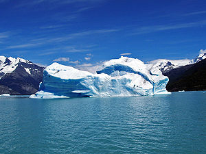
阿根廷湖的湖畔生长着高大的针叶松,四周是连绵的山峰,峰顶被白雪覆盖,泛蓝中又带绿色的湖水与山峰的倒影相接。接近冰川的地方能看到湖上漂浮的冰块,在湖水的映衬下,这些冰块就像发出蓝光一样。
冰川国家公园有多条大的冰川,其中,将阿根廷湖隔开成两半的莫雷诺冰川最为壮观。莫雷诺冰川目前还在不断生成,每天都向常温地带推进30厘米。20年前,这里每隔两年左右会发生一次冰川崩塌现象,人们想要看到这一景象,需要预测时间。然而,由于气候变暖的影响和冰舌推进至湖面的常温地带,冰川的融化速率渐渐加快,时常发生冰川崩塌的现象。有时,不到30分钟就会发生一次冰川崩塌,游客因此可以听到冰块落入湖中的隆隆声。[4]
参考资料
[编辑]- ^ UNEP-WCMC Protected Areas Programme, Los Glaciares National Park. [2010-07-07]. (原始内容存档于2008-11-15).
- ^ 阿根廷冰川国家公园基本信息. 米胖. 2007-06-04 [2010年7月6日]. (原始内容存档于2013-01-19) (中文).
- ^ Southern Patagonia. Southern Wonders. [2010年7月6日]. (原始内容存档于2014年9月18日) (英语).
- ^ 4.0 4.1 近距离观看阿根廷冰川国家公园. 中国经济信息网. [2010年7月6日]. (原始内容存档于2007年11月14日) (中文).
- ^ Ecological implications of projected climate change scenarios in forest ecosystems of central North America. [2010年7月6日] (英语).
- Alan Kearney. 1993. Mountaineering in Patagonia. Seattle USA: Cloudcap.
- Mermoz, M., Ramilo, E., Chehebar, C. y Martin, C. (1993). Plan General de Manejo Parque Nacional Los Glaciares. Administracion de Parques Nacionales. Mimeogr.
- Naruse, R. et al. (1991). Preliminary report of Glacier Research Project in Patagonia 1990. Informe inédito.
外部链接
[编辑]- 官方网站(页面存档备份,存于互联网档案馆) (英文)(西班牙文)
- 联合国教科文组织 (英文)
- 冰川国家公园 (英文)
- 动物(页面存档备份,存于互联网档案馆)(西班牙文)
- 自然景观(西班牙文)
- 冰川国家公园相关照片(页面存档备份,存于互联网档案馆) (英文)
- 虚拟游览冰川和湖泊 (英文)
| ||||||||||||||||||||
| ||||||||||||||||||||||||||||||||||||||||||
| ||||||||||||
Text is available under the CC BY-SA 4.0 license; additional terms may apply.
Images, videos and audio are available under their respective licenses.

