For faster navigation, this Iframe is preloading the Wikiwand page for चित्र:Peru physical map.svg.

चित्र:Peru physical map.svg
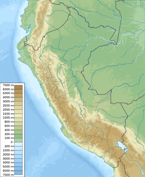
मूल फाइल(SVG फाइल,साधारण ८५१ × १,०३७ पिक्सेलहरु, फाइल आकार: ४.८१ मेगाबाइटहरू)

सारांश

वर्णन
English: Physical map of Peru, parameters are equal to File:Peru location map.svg
Español: mapa físico de Perú, los parámetros son iguales a File:Peru location map.svg
मिति
स्रोत मेरो आफ्नै कार्य, topographical information from Shuttle Radar Topography Mission
लेखक Urutseg
SVG genesis
InfoField
 
The SVG code is valid.
 
This oversized map was created with Adobe Illustrator,
 
and with Inkscape.
 
 This map uses embedded text that can be easily translated using a text editor.

अनुज्ञा प्राप्त गर्दै

I, the copyright holder of this work, hereby publish it under the following license:
Creative Commons CC-Zero This file is made available under the Creative Commons CC0 1.0 Universal Public Domain Dedication.
The person who associated a work with this deed has dedicated the work to the public domain by waiving all of their rights to the work worldwide under copyright law, including all related and neighboring rights, to the extent allowed by law. You can copy, modify, distribute and perform the work, even for commercial purposes, all without asking permission.

Captions

Add a one-line explanation of what this file represents
Physical map of Peru

Items portrayed in this file

जनाउँछ

some value

author name string अङ्ग्रेजी: Urutseg
Wikimedia username अङ्ग्रेजी: Urutseg

copyright status अङ्ग्रेजी

copyright license अङ्ग्रेजी

Creative Commons CC0 License अङ्ग्रेजी

source of file अङ्ग्रेजी

original creation by uploader अङ्ग्रेजी

५ मार्च 2011

media type अङ्ग्रेजी

image/svg+xml

फाइल इतिहास

मिति/समय मा क्लिक गरेर त्यससमयमा यो फाइल कस्तो थियो भनेर हेर्न सकिन्छ ।

मिति/समयछोटो चित्रआकारहरूप्रयोगकर्ताटिप्पणी
हालको१६:२७, ५ मार्च २०११छोटो चित्र १६:२७, ५ मार्च २०११ संस्करणको रुपमा८५१×१,०३७ (४.८१ मेगाबाइटहरू)Urutseg== Summary == ((Information |Description =((en|1=Physical map of Peru, parameters are equal to Bolivia location map.svg)) |Source =((own)) |Author =Urutseg |Date =2011-03-05 |Pe

फाइल प्रयोग

यस फाइलमा निम्न 3 पृष्ठहरू जोडिन्छन्:

विश्वव्यापी फाइल प्रयोग

निम्न अन्य विकिहरूमा यस फाइलको प्रयोग:

यस फाइलको विश्वव्यापी उपयोगको अधिक जानकारी हेर्नुहोस् ।

मेटाडाटा

{{bottomLinkPreText}} {{bottomLinkText}}
चित्र:Peru physical map.svg
Listen to this article

This browser is not supported by Wikiwand :(
Wikiwand requires a browser with modern capabilities in order to provide you with the best reading experience.
Please download and use one of the following browsers:

This article was just edited, click to reload
This article has been deleted on Wikipedia (Why?)

Back to homepage

Please click Add in the dialog above
Please click Allow in the top-left corner,
then click Install Now in the dialog
Please click Open in the download dialog,
then click Install
Please click the "Downloads" icon in the Safari toolbar, open the first download in the list,
then click Install
{{::$root.activation.text}}

Install Wikiwand

Install on Chrome Install on Firefox
Don't forget to rate us

Tell your friends about Wikiwand!

Gmail Facebook Twitter Link

Enjoying Wikiwand?

Tell your friends and spread the love:
Share on Gmail Share on Facebook Share on Twitter Share on Buffer

Our magic isn't perfect

You can help our automatic cover photo selection by reporting an unsuitable photo.

This photo is visually disturbing This photo is not a good choice

Thank you for helping!


Your input will affect cover photo selection, along with input from other users.

X

Get ready for Wikiwand 2.0 🎉! the new version arrives on September 1st! Don't want to wait?