For faster navigation, this Iframe is preloading the Wikiwand page for ფაილი:Peru physical map.svg.

ფაილი:Peru physical map.svg
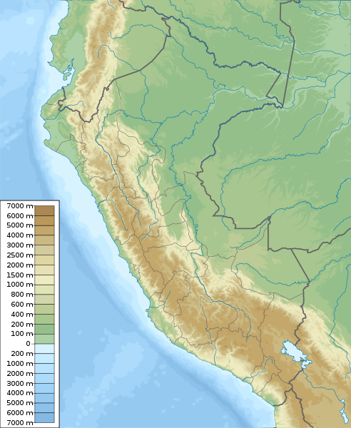
თავდაპირველი ფაილი(ფაილი SVG, ნომინალურად 851 × 1 037 პიქსელი, ფაილის ზომა: 4,81 მბ)

ეს ფაილი მდებარეობს Wikimedia Commons სერვერზე.
იხილეთ მისი აღწერის გვერდი სრული ინფორმაციისთვის.
გადასვლა ფაილის გვერდზე

რეზიუმე

აღწერა
English: Physical map of Peru, parameters are equal to File:Peru location map.svg
Español: mapa físico de Perú, los parámetros son iguales a File:Peru location map.svg
თარიღი
წყარო პირადი ნამუშევარი, topographical information from Shuttle Radar Topography Mission
ავტორი Urutseg
SVG genesis
InfoField
 
ამ SVG ფაილის კოდი კორექტულია.
 
This oversized map was created with Adobe Illustrator,
 
and with Inkscape.
 
 This map uses embedded text that can be easily translated using a text editor.

ლიცენზია

მე, ამ ნამუშევარზე საავტორო უფლებების მფლობელი, ვაქვეყნებ მას შემდეგი ლიცენზიით:
Creative Commons CC-Zero ეს ფაილი ვრცელდება Creative Commons CC0 1.0 Universal Public Domain Dedication ლიცენზიით.
პიროვნებებმა, რომლებიც ერთობლივად მუშაობდნენ ამ ნამუშევარზე, გადაწყვიტეს ამ ნამუშევრის გადაცემა საზოგადოებრივ საკუთრებაში, უარი განაცხადეს ნამუშევრის ყველა უფლებაზე მსოფლიო საავტორო უფლებების კანონის იმ ფარგლებში (მათ შორის სხვა უფლებებიც) რომელიც დაშვებულია კანონის მიხედვით. თქვენ შეგიძლიათავტორის ნებართვის გარეშე დააკოპიროთ, შეცვალოთ, გაავრცელოთ, გამოიყენოთ აღნიშნული ნამუშევარი ნებისმიერი მიზნით, მათ შორის კომერციულითაც.

Captions

Add a one-line explanation of what this file represents
Physical map of Peru

source of file ინგლისური

original creation by uploader ინგლისური

media type ინგლისური

image/svg+xml

ფაილის ისტორია

დააწკაპუნეთ თარიღზე/დროზე ფაილის დასათვალიერებლად, როგორც ის მაშინ გამოიყურებოდა.

თარიღი/დრომინიატიურაზომებიმომხმარებელიშენიშვნა
მიმდინარე10:42, 5 მარტი 2011მინიატურა 10:42, 5 მარტი 2011 ვერსიისთვის851×1 037 (4,81 მბ)Urutseg== Summary == ((Information |Description =((en|1=Physical map of Peru, parameters are equal to Bolivia location map.svg)) |Source =((own)) |Author =Urutseg |Date =2011-03-05 |Pe

ბმულები

ფაილის გლობალური გამოყენება

ეს ფაილი გამოიყენება შემდეგ ვიკებში:

იხილეთ, ამ ფაილის გლობალური გამოყენება.

მეტამონაცემები

მოძიებულია „https://ka.wikipedia.org/wiki/ფაილი:Peru_physical_map.svg“-დან
{{bottomLinkPreText}} {{bottomLinkText}}
ფაილი:Peru physical map.svg
Listen to this article

This browser is not supported by Wikiwand :(
Wikiwand requires a browser with modern capabilities in order to provide you with the best reading experience.
Please download and use one of the following browsers:

This article was just edited, click to reload
This article has been deleted on Wikipedia (Why?)

Back to homepage

Please click Add in the dialog above
Please click Allow in the top-left corner,
then click Install Now in the dialog
Please click Open in the download dialog,
then click Install
Please click the "Downloads" icon in the Safari toolbar, open the first download in the list,
then click Install
{{::$root.activation.text}}

Install Wikiwand

Install on Chrome Install on Firefox
Don't forget to rate us

Tell your friends about Wikiwand!

Gmail Facebook Twitter Link

Enjoying Wikiwand?

Tell your friends and spread the love:
Share on Gmail Share on Facebook Share on Twitter Share on Buffer

Our magic isn't perfect

You can help our automatic cover photo selection by reporting an unsuitable photo.

This photo is visually disturbing This photo is not a good choice

Thank you for helping!


Your input will affect cover photo selection, along with input from other users.

X

Get ready for Wikiwand 2.0 🎉! the new version arrives on September 1st! Don't want to wait?