牧島 (熊本県)
| 牧島 | |
|---|---|
| 所在地 |
|
| 所属諸島 | 天草諸島 |
| 座標 | 北緯32度21分20秒 東経130度19分7秒 / 北緯32.35556度 東経130.31861度 |
| 面積 | 5.63 km² |
| 海岸線長 | 24.8 km |
| 最高標高 | 167.6 m |
 牧島 牧島 (熊本県)  牧島 牧島 (日本) | |

概要
牧島の南にある御所浦島では1997年(平成9年)に恐竜化石が発見されたため「恐竜の島」と呼ばれているが、牧島でも古第三紀の大型哺乳動物の化石を産する[1]。
-
 牧島のアンモナイト館
 -
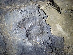 牧島で見つかったアンモナイト
 -
 中瀬戸橋と恐竜の骨格像
 -
 牧島の静かなたたずまい


交通
御所浦島と中瀬戸橋で結ばれている。
脚注
- ^ 長谷 義隆『海にうかぶ博物館 天草ジオパーク』22世紀アート、2020年10月20日、19頁
関連項目
外部リンク
日本の有人指定離島 | |
|---|---|
|
非実効支配下の島は除く。※印は民間人の定住者が居ない島嶼。太字は特定有人国境離島地域に指定されている島嶼。 | |
Text is available under the CC BY-SA 4.0 license; additional terms may apply.
Images, videos and audio are available under their respective licenses.
Cover photo is available under {{::mainImage.info.license.name || 'Unknown'}} license.
Cover photo is available under {{::mainImage.info.license.name || 'Unknown'}} license.
Credit:
(see original file).
