Pas de San Francisco
| ||||
| Tipus | Port de muntanya | |||
|---|---|---|---|---|
| Localització | ||||
| País | ||||
| Regió/prov. | Regió d'Atacama, Chile - Catamarca, Argentina | |||
| ||||
| Serralada | Andes | |||
| Dades i xifres | ||||
| Altitud | 4.726 m | |||
| Hi passa | Ruta CH-31 (Xile) - Ruta Nacional 60 (Argentina) | |||


El Pas de San Francisco (castellà: Paso de San Francisco) és un coll fronterer entre les repúbliques de Xile i Argentina, situat en la serralada dels Andes a una altura de 4.726 metres sobre el nivell mitjà del mar.[1] Uneix la II Regió d'Atacama, Xile amb la Província de Catamarca, Argentina.[2]
Galeria
[modifica]-
 Paisatge, costat argentí
 -
 Laguna verde
 -
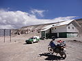 Punt de control de la polica xilena


Referències
[modifica]- ↑ «Pasos fronterizos» (en castellà). Ministerio de Relaciones Exteriores de Chile. Arxivat de l'original el 2015-04-02. [Consulta: 4 març 2015].
- ↑ «Paso Internacional San Francisco» (en castellà). Gendarmeria Nacional Argentina. Arxivat de l'original el 2015-02-27. [Consulta: 5 març 2015].
Colls de la serralada dels Andes | |
|---|---|
| Colls fronterers Bolívia - Xile | Visviri · Chungará - Tambo Quemado · Colchane - Pisiga · Salar de Ollagüe · Portezuelo de Chaxas · Portezuelo del Cajón |
| Colls fronterers Argentina - Xile | Jama · Sico · Socompa · San Francisco · Pircas Negras · Agua Negra · Los Patos · Uspallata · Alliberadors · Pichachén · Pino Hachado · Mamuil Malal · Carirriñe · Hua Hum · Lilpela · Cardenal Samoré |
NB: en ordre geogràfic de nord a sud | |
Text is available under the CC BY-SA 4.0 license; additional terms may apply.
Images, videos and audio are available under their respective licenses.
Cover photo is available under {{::mainImage.info.license.name || 'Unknown'}} license.
Cover photo is available under {{::mainImage.info.license.name || 'Unknown'}} license.
Credit:
(see original file).
