Pas Cardenal Samoré
| ||||
| Tipus | Muntanya i port de muntanya | |||
|---|---|---|---|---|
| Localitzat en l'àrea protegida | Parc Nacional Nahuel Huapi | |||
| ||||
| Serralada | Andes | |||
| Dades i xifres | ||||
| Altitud | 1.305 m | |||


El Pas Cardenal Samoré (castellà: Paso Fronterizo Internacional Cardenal Antonio Samoré) és un coll fronterer entre les repúbliques de Xile i Argentina, situat en la serralada dels Andes a una altura de 1.305 metres sobre el nivell mitjà del mar.[1] Uneix la X Regió de Los Lagos, Xile amb la Província de Río Negro, Argentina a través de la ruta CH-215 de Xile i la Ruta Nacional 231 de Argentina.[2]
Galeria
[modifica]-
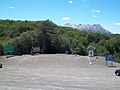 El Pas, costat xilè i costat argentí.
 -
 Punt límit del Pas.

Referències
[modifica]- ↑ «Pasos fronterizos» (en castellà). Ministerio de Relaciones Exteriores de Chile. Arxivat de l'original el 2016-03-08. [Consulta: 8 març 2016].
- ↑ «Paso Internacional Cardenal Samoré» (en castellà). Gendarmeria Nacional Argentina. Arxivat de l'original el 2015-01-07. [Consulta: 8 març 2016].
Enllaços externs
[modifica]A Wikimedia Commons hi ha contingut multimèdia relatiu a: Pas Cardenal Samoré
- Pas Cardenal Samoré Arxivat 2013-10-16 a Wayback Machine. (en castellà)
Colls de la serralada dels Andes | |
|---|---|
| Colls fronterers Bolívia - Xile | Visviri · Chungará - Tambo Quemado · Colchane - Pisiga · Salar de Ollagüe · Portezuelo de Chaxas · Portezuelo del Cajón |
| Colls fronterers Argentina - Xile | Jama · Sico · Socompa · San Francisco · Pircas Negras · Agua Negra · Los Patos · Uspallata · Alliberadors · Pichachén · Pino Hachado · Mamuil Malal · Carirriñe · Hua Hum · Lilpela · Cardenal Samoré |
NB: en ordre geogràfic de nord a sud | |
Text is available under the CC BY-SA 4.0 license; additional terms may apply.
Images, videos and audio are available under their respective licenses.
Cover photo is available under {{::mainImage.info.license.name || 'Unknown'}} license.
Cover photo is available under {{::mainImage.info.license.name || 'Unknown'}} license.
Credit:
(see original file).
