ملف:Abbasid Caliphate most extant.png
لا توجد دقة أعلى متوفرة.
Abbasid_Caliphate_most_extant.png (800 × 487 بكسل حجم الملف: 85 كيلوبايت، نوع MIME: image/png)
| هذا ملف من ويكيميديا كومنز. معلومات من صفحة وصفه مبينة في الأسفل. كومنز مستودع ملفات ميديا ذو رخصة حرة. |
| الوصف |
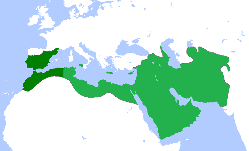
English: Locator map for the Abbasid Caliphate at its greatest extent, before the independence of al-Maghrib (Morocco and parts of Algeria) in 744 as well as al-Andalus (Spain and Portugal) in 756 |
| التاريخ | (UTC) |
| المصدر | |
| المؤلف |
|
| هذا رسمٌ مُعَدَّلٌ رقميَّاً من النسخة الأصليَّة. التعديلات هي: seperated the parts that gained independance from the Abbasid Caliphate. يُمكن الاطلاع على النسخة الأصليَّة هنا: Umayyad750ADloc.png:
|
أنا، صاحب حقوق التأليف والنشر لهذا العمل، أنشر هذا العمل تحت الرخصة التالية:
هذا الملف مُرخص تحت رخصة المشاع المبدع نسبة المصنف إلى مؤلفه 3.0 العامة
- يحقُّ لك:
- مشاركة العمل – نسخ العمل وتوزيعه وبثُّه
- إعادة إنتاج العمل – تعديل العمل
- حسب الشروط التالية:
- نسب العمل إلى مُؤَلِّفه – يلزم نسب العمل إلى مُؤَلِّفه بشكل مناسب وتوفير رابط للرخصة وتحديد ما إذا أجريت تغييرات. بالإمكان القيام بذلك بأية طريقة معقولة، ولكن ليس بأية طريقة تشير إلى أن المرخِّص يوافقك على الاستعمال.
سجلُّ الرَّفع الأصيل
This image is a derivative work of the following images:
- File:Umayyad750ADloc.png licensed with Cc-by-3.0
- 2009-04-22T16:17:51Z Gabagool 1481x902 (51495 Bytes) some corrections..
- 2009-04-20T16:10:54Z Gabagool 1481x902 (51573 Bytes) ((Information |Description=((en|1=Locator map for the Umayyad Caliphate at its greatest extent, c. AD 750. (Partially based on ''Atlas of World History'' (2007) - World 500-750, map.))) |Source=Own work by uploader |Author=[
Uploaded with derivativeFX
تاريخ الملف
اضغط على زمن/تاريخ لرؤية الملف كما بدا في هذا الزمن.
| زمن/تاريخ | صورة مصغرة | الأبعاد | مستخدم | تعليق | |
|---|---|---|---|---|---|
| حالي | 18:50، 13 أبريل 2013 | | 800 × 487 (85 كيلوبايت) | Fry1989 | vandalism |
| 16:01، 13 أبريل 2013 |  | 800 × 487 (87 كيلوبايت) | Mouh2jijel | Reverted to version as of 08:30, 13 April 2013 | |
| 14:32، 13 أبريل 2013 |  | 800 × 487 (85 كيلوبايت) | Omar-toons | Reverted to version as of 23:40, 15 November 2012 rv unjustified revert | |
| 08:30، 13 أبريل 2013 |  | 800 × 487 (87 كيلوبايت) | Mouh2jijel | Reverted to version as of 18:50, 8 April 2013 | |
| 06:18، 13 أبريل 2013 |  | 800 × 487 (85 كيلوبايت) | Omar-toons | Reverted to version as of 23:40, 15 November 2012 unjustified revert | |
| 18:50، 8 أبريل 2013 |  | 800 × 487 (87 كيلوبايت) | Mouh2jijel | Reverted to version as of 17:29, 24 April 2012 | |
| 23:40، 15 نوفمبر 2012 |  | 800 × 487 (85 كيلوبايت) | Omar-toons | moving southern Ifriqiyan limits a little bit to the north | |
| 17:29، 24 أبريل 2012 |  | 800 × 487 (87 كيلوبايت) | Cplakidas | corrections: Sardinia and Corsica were never taken, and Sicily was not completely conquered until the 870s | |
| 19:11، 25 أبريل 2011 |  | 800 × 487 (87 كيلوبايت) | باسم | added a few Mediterranean islands | |
| 18:12، 25 أبريل 2011 |  | 800 × 487 (87 كيلوبايت) | باسم | ((Information |Description=((en|1=Locator map for the Abbasid Caliphate at its greatest extent, before the independence of al maghrib (morocco and parts of algeria) as well as al andalus (Spain and Portugal))) |Source=*File:Umayyad750ADloc.png |Date |
استخدام الملف
أكثر من 100 صفحة تستخدم هذا الملف. القائمة التالية تعرض فقط أول 100 صفحة تستخدم هذا الملف. قائمة كاملة متوفرة.
- البصرة
- الدولة العباسية
- العراق
- الفضل البرمكي
- الممالك في إفريقيا قبل الاستعمار
- برامكة
- برمك المجوسي
- بغداد
- تاريخ إسلامي
- تاريخ العراق
- تاريخ اليمن الإسلامي
- جحظة البرمكي
- خالد بن برمك
- خلافة إسلامية
- غامد
- قائمة الخلفاء
- محمد بن يحيى بن خالد البرمكي
- موسى البرمكي
- يحيى البرمكي
- مستخدم:باحث
- ويكيبيديا:قائمة اليوم المختارة/أغسطس 2015
- ويكيبيديا:قائمة اليوم المختارة/أغسطس 2016
- ويكيبيديا:قائمة اليوم المختارة/فبراير 2017
- ويكيبيديا:قائمة اليوم المختارة/مارس 2016
- ويكيبيديا:قائمة اليوم المختارة/مارس 2018
- ويكيبيديا:قائمة اليوم المختارة/نوفمبر 2015
- ويكيبيديا:قائمة اليوم المختارة/نوفمبر 2017
- ويكيبيديا:قائمة اليوم المختارة/يناير 2016
- ويكيبيديا:قائمة اليوم المختارة/يوليو 2015
- ويكيبيديا:قائمة اليوم المختارة/يوليو 2017
- ويكيبيديا:قائمة اليوم المختارة/يونيو 2018
- ويكيبيديا:مقالة الصفحة الرئيسية المختارة/152
- قالب:برامكة
- قالب:بوابات الإمبراطوريات
- قالب:قائمة اليوم المختارة/2015-07-04
- قالب:قائمة اليوم المختارة/2015-08-25
- قالب:قائمة اليوم المختارة/2015-11-01
- قالب:قائمة اليوم المختارة/2016-01-25
- قالب:قائمة اليوم المختارة/2016-03-22
- قالب:قائمة اليوم المختارة/2016-08-20
- قالب:قائمة اليوم المختارة/2017-02-09
- قالب:قائمة اليوم المختارة/2017-07-26
- قالب:قائمة اليوم المختارة/2017-11-28
- قالب:قائمة اليوم المختارة/2018-03-10
- قالب:قائمة اليوم المختارة/2018-06-23
- قالب:مواضيع متعلقة 3
- قالب:مواضيع متعلقة 3/شرح
- بوابة:إمبراطوريات
- بوابة:إمبراطوريات/بوابات شقيقة
- بوابة:إمبراطورية اليابان
- بوابة:إمبراطورية اليابان/بوابات شقيقة
- بوابة:الأديان/تاريخ ديني
- بوابة:الأديان/تاريخ ديني/7
- بوابة:الإسلام/دولة مختارة
- بوابة:الإسلام/دولة مختارة/3
- بوابة:الإسلام/مقالة مختارة
- بوابة:الإسلام/مقالة مختارة/14
- بوابة:الإمبراطورية الألمانية
- بوابة:الإمبراطورية الألمانية/بوابات شقيقة
- بوابة:الإمبراطورية الإسبانية
- بوابة:الإمبراطورية الإسبانية/بوابات شقيقة
- بوابة:الإمبراطورية البرتغالية
- بوابة:الإمبراطورية البرتغالية/بوابات شقيقة
- بوابة:الإمبراطورية البريطانية
- بوابة:الإمبراطورية البريطانية/بوابات شقيقة
- بوابة:الإمبراطورية الروسية
- بوابة:الإمبراطورية الروسية/بوابات شقيقة
- بوابة:الإمبراطورية الرومانية المقدسة
- بوابة:الإمبراطورية الرومانية المقدسة/بوابات شقيقة
- بوابة:الإمبراطورية الفرنسية الأولى
- بوابة:الإمبراطورية الفرنسية الأولى/بوابات شقيقة
- بوابة:الإمبراطورية الفرنسية الثانية
- بوابة:الإمبراطورية الفرنسية الثانية/بوابات شقيقة
- بوابة:الإمبراطورية المغولية
- بوابة:الإمبراطورية المغولية/بوابات شقيقة
- بوابة:الإمبراطورية النمساوية
- بوابة:الإمبراطورية النمساوية/بوابات شقيقة
- بوابة:الإمبراطورية النمساوية المجرية
- بوابة:الإمبراطورية النمساوية المجرية/بوابات شقيقة
- بوابة:التاريخ/فقرات منوعة/3
- بوابة:التاريخ/فقرات منوعة/أرشيف
- بوابة:التاريخ الإسلامي/دولة مختارة/4
- بوابة:التاريخ الإسلامي/دولة مختارة/أرشيف
- بوابة:التاريخ الإسلامي/مقالة مختارة/17
- بوابة:التاريخ الإسلامي/مقالة مختارة/أرشيف
- بوابة:الخلافة الراشدة
- بوابة:الخلافة الراشدة/بوابات شقيقة
- بوابة:الدولة الأموية
- بوابة:الدولة الأموية/بوابات شقيقة
- بوابة:الدولة العباسية
- بوابة:الدولة العباسية/واجهة
- بوابة:العالم الإسلامي
- بوابة:العالم الإسلامي/تاريخ
- بوابة:العالم الإسلامي/مواضيع متعلقة
- بوابة:العراق/مقالة مختارة/2
- بوابة:العراق/مقالة مختارة/أرشيف
- بوابة:العصور الوسطى/مقالة مختارة
- بوابة:العصور الوسطى/مقالة مختارة/1
- بوابة:مكة/مقالة مختارة/10
- بوابة:مكة/مقالة مختارة/أرشيف
عرض المزيد من الوصلات إلى هذا الملف.
الاستخدام العالمي للملف
الويكيات الأخرى التالية تستخدم هذا الملف:
- الاستخدام في arz.wikipedia.org
- الاستخدام في av.wikipedia.org
- الاستخدام في az.wikipedia.org
- الاستخدام في ba.wikipedia.org
- الاستخدام في be-tarask.wikipedia.org
- الاستخدام في be.wikipedia.org
- الاستخدام في ce.wikipedia.org
- الاستخدام في ckb.wikipedia.org
- الاستخدام في crh.wikipedia.org
- الاستخدام في cs.wikipedia.org
- الاستخدام في diq.wikipedia.org
- الاستخدام في en.wikipedia.org
- الاستخدام في eo.wikipedia.org
- الاستخدام في es.wikipedia.org
- الاستخدام في eu.wikipedia.org
- الاستخدام في fa.wikipedia.org
- الاستخدام في fi.wikipedia.org
- الاستخدام في gl.wikipedia.org
- الاستخدام في hi.wikipedia.org
- الاستخدام في id.wikipedia.org
- الاستخدام في id.wikibooks.org
- الاستخدام في ja.wikipedia.org
- الاستخدام في kk.wikipedia.org
- الاستخدام في ku.wikipedia.org
- الاستخدام في ky.wikipedia.org
- الاستخدام في pnb.wikipedia.org
اعرض المزيد من الاستخدام العام لهذا الملف.
Text is available under the CC BY-SA 4.0 license; additional terms may apply.
Images, videos and audio are available under their respective licenses.
Cover photo is available under {{::mainImage.info.license.name || 'Unknown'}} license.
Cover photo is available under {{::mainImage.info.license.name || 'Unknown'}} license.
Credit:
(see original file).
