For faster navigation, this Iframe is preloading the Wikiwand page for File:First ETR in China.svg.

File:First ETR in China.svg
原始文件(SVG文件,尺寸为1,000 × 850像素,文件大小:232 KB)


摘要

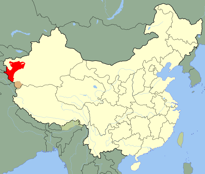
描述 A SVG map of China with Xinjiang's Kashgar Prefecture highlighted in red; the modern-day district in which the w:en:First East Turkestan Republic was located. Legend:
日期 (UTC)
来源
作者
SVG开发
InfoField
 
SVG的源代码为有效代码
 
矢量图使用Inkscape创作。
这是一张修改过的图片,这意味着它已在原版本的基础上通过软件进行了编辑,改动内容:Unhighlighted Xinjiang as a whole, removed sub-provincial markers。其原始版本为:China blank map (1936).svg。修改者:Splittist

这是一张修改过的图片,这意味着它已在原版本的基础上通过软件进行了编辑,改动内容:Unhighlighted Xinjiang as a whole, removed sub-provincial markers。其原始版本为:China Xinjiang Kashgar.svg。修改者:Splittist

许可协议

我,本作品著作权人,特此采用以下许可协议发表本作品:
Public domain 我,本作品著作权人,释出本作品至公有领域。这适用于全世界。
在一些国家这可能不合法;如果是这样的话,那么:
我无条件地授予任何人以任何目的使用本作品的权利,除非这些条件是法律规定所必需的。

原始上传日志

This image is a derivative work of the following images:

  • File:China_Xinjiang_Kashgar.svg licensed with PD-self
    • 2010-02-12T14:52:39Z Joowwww 1000x850 (237684 Bytes) ((Information |Description=An SVG map of China with Xinjiang highlighted in orange and Kashgar Prefecture highlighted in red Legend:[[:File:China map legend.png]] |Source=self-made; based on CIA public domain maps: *http://w

Uploaded with derivativeFX

说明

添加一行文字以描述该文件所表现的内容

此文件中描述的项目

描繪內容

image/svg+xml

文件历史

点击某个日期/时间查看对应时刻的文件。

日期/时间缩⁠略⁠图大小用户备注
当前2020年5月24日 (日) 21:102020年5月24日 (日) 21:10版本的缩略图1,000 × 850(232 KB)Roy17Reverted to version as of 23:09, 18 August 2010 (UTC)
2020年5月24日 (日) 02:392020年5月24日 (日) 02:39版本的缩略图1,000 × 810(249 KB)AnchuhuReverted to version as of 12:39, 19 January 2019 (UTC) roc borders isn’t like China now
2020年3月12日 (四) 01:432020年3月12日 (四) 01:43版本的缩略图1,000 × 850(232 KB)JonteemilReverted to version as of 23:09, 18 August 2010 (UTC)
2019年1月19日 (六) 12:392019年1月19日 (六) 12:39版本的缩略图1,000 × 810(249 KB)复旦大学张超edit
2010年8月18日 (三) 23:092010年8月18日 (三) 23:09版本的缩略图1,000 × 850(232 KB)Splittist((Information |Description=A SVG map of China with Xinjiang's Kashgar Prefecture highlighted in red; the modern-day district in which the w:en:First East Turkestan Republic was located. Legend:<br />File:China map legend.png |Source=*[[:File:China

文件用途

全域文件用途

以下其他wiki使用此文件:

查看此文件的更多全域用途

元数据

{{bottomLinkPreText}} {{bottomLinkText}}
File:First ETR in China.svg
Listen to this article

This browser is not supported by Wikiwand :(
Wikiwand requires a browser with modern capabilities in order to provide you with the best reading experience.
Please download and use one of the following browsers:

This article was just edited, click to reload
This article has been deleted on Wikipedia (Why?)

Back to homepage

Please click Add in the dialog above
Please click Allow in the top-left corner,
then click Install Now in the dialog
Please click Open in the download dialog,
then click Install
Please click the "Downloads" icon in the Safari toolbar, open the first download in the list,
then click Install
{{::$root.activation.text}}

Install Wikiwand

Install on Chrome Install on Firefox
Don't forget to rate us

Tell your friends about Wikiwand!

Gmail Facebook Twitter Link

Enjoying Wikiwand?

Tell your friends and spread the love:
Share on Gmail Share on Facebook Share on Twitter Share on Buffer

Our magic isn't perfect

You can help our automatic cover photo selection by reporting an unsuitable photo.

This photo is visually disturbing This photo is not a good choice

Thank you for helping!


Your input will affect cover photo selection, along with input from other users.

X

Get ready for Wikiwand 2.0 🎉! the new version arrives on September 1st! Don't want to wait?