斷層跡


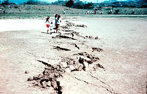
斷層跡(英語:Fault trace)是指斷層與地球表面的交匯處痕跡,看起來像地球表面的裂縫,有是有向外突出的鋸齒狀岩石結構。斷層跡也指在地質圖上代表斷層的位置和分佈。 在地震期間,地殼往往會發生裂縫。而裂縫兩側的地塊往往發位移,就造成斷層。其位移可能是水平或垂直的分離。沿裂縫兩側的地塊稱為斷塊 [1]。
不同斷層造成的斷層跡
[编辑]斷層可以通過斷塊之間的相對運動來區分。 走滑斷層其兩側斷塊之間運動主要是水平的,垂直分離通常不多。 其斷層運動是平行於斷層跡,通常是由下伏板塊構造引起的。 這些斷層跡通常可由地面上的線性特徵來識別,例如柵欄線或小溪流被錯開。 由照片可看出柵欄綫被錯開一米或兩米,在它們之間有空隙。 在自然界中,線狀特徵並不常見,但可以幫助識別斷層等地質特徵[2]。
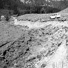
當斷層的運動是垂直於斷層跡時,就有沿傾角方向的分離。 也就是說,斷塊彼此之間會被拉開或彼此被推擠。 這就是傾滑斷層。傾角方向的分離會導致斷塊之間的垂直分離。 若受拉伸力,則造成一個斷塊塊下降,若受擠壓力,則造成一個斷塊被推到另一斷塊的上部。 這些斷層活動也是受區域板塊構造引起的。 這種垂直分離也能造成斷層崖,並曝露前被掩埋的斷層跡[3]。
綫索證據
[编辑]斷層崖
[编辑]
斷層崖是由兩個斷塊之間的垂直活動引起的陡坡。 它的高度大到幾米小至幾厘米,而高度小的斷層崖會土石流和侵蝕迅速抹平。
植被變化
[编辑]隨著斷層的活動,地表的物質都會受到干擾。 也會導致不同礦物組成的岩石和沈積物以及流體被帶到地表。 使周圍的土壤含不同的營養物質和元素。這就導致植被的明顯變化並形成斷層痕跡。
綫理
[编辑]不僅斷層痕蹟有大尺度的線性特徵,在岩石樣本或岩石表面上也可看出斷層痕蹟。擦痕面就是一種岩石相互磨削而成的線條。研究擦痕面可指示斷層及其運動方向。
地形變化
[编辑]與斷層崖類似,地形高度變化通為斷層的指標。 斷層活動的能使,一部分土地下降或向上推,這就在地形上留下明顯的線性斷層跡指標。
里德爾剪刀
[编辑]Riedel 剪切結構是一種在剪切帶內。 早期斷層發育的結構。當它們沿線性方向相互連接時,就形成完整的斷層結構[4]。 地質圖上的斷層跡 在地質圖上,斷層跡被繪製成線。 并標示傾角方向、傾角、斷層類型和斷層的運動方向[5]。
參考文獻
[编辑]- ^ Torabi, Anita; Berg, Silje Støren (2011-08-01). "Scaling of fault attributes: A review". Marine and Petroleum Geology. 28 (8): 1444–1460. doi:10.1016/j.marpetgeo.2011.04.003. ISSN 0264-8172.
- ^ Balance, P. F. (2009-04-08). Sedimentation in Oblique-slip Mobile Zones. John Wiley & Sons. ISBN 978-1-4443-0374-2.
- ^ Bouchon, Michel (1980). "The motion of the ground during an earthquake: 2. The case of a dip slip fault". Journal of Geophysical Research: Solid Earth. 85 (B1): 367–375. doi:10.1029/JB085iB01p00367. ISSN 2156-2202.
- ^ Katz, Yoram; Weinberger, Ram; Aydin, Atilla (2004-03-01). "Geometry and kinematic evolution of Riedel shear structures, Capitol Reef National Park, Utah". Journal of Structural Geology. 26 (3): 491–501. doi:10.1016/j.jsg.2003.08.003. ISSN 0191-8141.
- ^ Philip, G. (2007-11-01). "Remote sensing data analysis for mapping active faults in the northwestern part of Kangra Valley, NW Himalaya, India". International Journal of Remote Sensing. 28 (21): 4745–4761. doi:10.1080/01431160701264243. ISSN 0143-1161. S2CID 129833739.
Text is available under the CC BY-SA 4.0 license; additional terms may apply.
Images, videos and audio are available under their respective licenses.
