斷塊


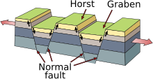
斷塊(英語:Fault block)是由地殼中的構造和局部應力造成的非常大的岩石塊,有時長達數百公里。大面積的基岩能被斷層破碎成塊。斷塊的特點是相對均勻的岩性。這些斷塊中最大的稱為地殼塊。從板塊中分離出來的大型地殼塊被稱為地體[1]。 具岩石圈全部厚度的地體稱為微板塊。大陸大小的斷塊被稱為各種微大陸、大陸帶、H 塊、伸展異地塊和外高地[2]。 由於大多數應力與板塊的構造活動有關,因此斷塊之間的大多數運動是水平的,即與地殼平行的走滑斷層。然而,斷塊的垂直位移較大時,會形成地貌(山、丘、脊、湖、谷等)。相鄰地壘和地塹可以形成高懸崖。由於地殼的壓實或拉伸作用,這些塊體的移動通常伴隨著傾斜[3]。
斷塊山脈
[编辑]


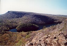
斷塊山脈通常是由裂谷作用產生的,這是伸展構造的一個指標。由裂谷系統形成的斷塊山脈大小不一[4],例如東非裂谷帶。加利福尼亞的死亡谷是一個較小的例子。有兩種主要類型的塊狀山脈;兩個斷層之間的抬升型塊體和主要受一個斷層控制的傾斜塊體。
抬升型塊狀山脈有兩個陡峭的側面,露出兩側的陡坡,例如在歐洲各地的地壘和地塹地形,包括上萊茵河谷,兩個地壘之間的地塹 - 孚日山脈(法國)和黑森林(在德國),以及保加利亞和東南歐的里拉 - 羅多彼地塊,包括地壘形的 Belasitsa 地壘(線性地壘)、和里拉山(拱形圓頂形地壘)。皮林山 –是一個地壘形成一個巨大的背斜,位於Struma 和 Mesta 的複雜地塹谷[5] [6] [7]。
傾斜型塊狀山脈有一側平緩傾斜和一側陡峭的陡坡,在美國西部的盆地和山脈地區很常見。
地塹的一個例子是印度的納爾馬達河盆地,位於 Vindhya 和 Satpura 地壘之間。
參考文獻
[编辑]- ^ A crustal block may or may not also comprise a tectonostratigraphic terrane that has a specific geologic definition. Bulter, Robert F. (1992) "Chapter 11: Applications to Regional Tectonics" Paleomagnetism: Magnetic Domains to Geologic Terranes Blackwell, pp. 205–223, page 205, archived here by Internet Archive on 26 October 2004
- ^ Péron-Pinvidic, Gwenn; Manatschal, Gianreto (2010). "From microcontinents to extensional allochthons: witnesses of how continents rift and break apart?". Petroleum Geoscience. 16 (3): 189. doi:10.1144/1354-079309-903. S2CID 131142997.
- ^ Plummer, Charles, David McGeary, and Diane Carlson. Physical Geology 8th ed. McGraw-Hill, Boston, 1999.
- ^ Monroe, James S., and Reed Wicander. The Changing Earth: Exploring Geology and Evolution. 2nd educational Belmont: Wadsworth Publishing Company, 1997. ISBN 0-314-09577-2 (pp. 234,-8)
- ^ Мичев (Michev), Николай (Nikolay); Михайлов (Mihaylov), Цветко (Tsvetko); Вапцаров (Vaptsarov), Иван (Ivan); Кираджиев (Kiradzhiev), Светлин (Svetlin) (1980). Географски речник на България [Geographic Dictionary of Bulgaria] (in Bulgarian). Sofia: Наука и култура (Nauka i kultura). p. 368.
- ^ Димитрова (Dimitrova), Людмила (Lyudmila) (2004). Национален парк "Пирин". План за управление [Pirin National Park. Management Plan] (in Bulgarian). и колектив. Sofia: Ministry of Environment and Water, Bulgarian Foundation "Biodiversity". p. 53.
- ^ Дончев (Donchev), Дончо (Doncho); Каракашев (Karakashev), Христо (Hristo) (2004). Теми по физическа и социално-икономическа география на България [Topics on Physical and Social-Economic Geography of Bulgaria] (in Bulgarian). Sofia: Ciela. pp. 128–129. ISBN 954-649-717-7.
Text is available under the CC BY-SA 4.0 license; additional terms may apply.
Images, videos and audio are available under their respective licenses.
