阿肯色县
| 阿肯色县 Arkansas County | |
|---|---|
| 县 | |
 | |
 阿肯色县于阿肯色州中的位置 | |
 阿肯色州于美国的位置 | |
| 坐标:34°16′27″N 91°23′02″W / 34.2742°N 91.3839°W | |
| 国家 | |
| 州 | |
| 设立日期 | 1813年12月13日[1] |
| 语源 | 阿肯色河 |
| 县治 | 斯图加特(北区) 迪威特(南区) |
| 最大城市 | 斯图加特 |
| 面积[2] | |
| • 总计 | 1,033.79 平方英里(3,000 平方公里) |
| • 陆地 | 988.49 平方英里(3,000 平方公里) |
| • 水域 | 45.30 平方英里(100 平方公里) 4.4% |
| 人口(2020年) | |
| • 总计 | 17,149人 |
| • 密度 | 17人/平方英里(7人/平方公里) |
| 时区 | 中部时区(UTC−6) |
| • 夏时制 | 中部时区(UTC−5) |
| 包含的国会选区 | 第1选区 |
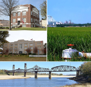
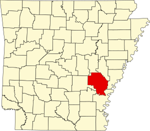
阿肯色县(英语:Arkansas County)是美国阿肯色州东南部的一个县,面积2,678平方公里。根据2020年美国人口普查,本县共有人口17,149人。[3]本县共有两个县治:迪威特(De Witt)和斯图加特(Stuttgart)。[4]
本县于1813年12月13日成立,是该州最早成立的县。县名来自当地的原住民夸保族。[5]本县是美国七个县名与州名相同的县份之一。
地理
[编辑]
根据2000年人口普查,阿肯色县的总面积为1,033.79平方英里(2,677.5平方千米),其中有988.49平方英里(2,560.2平方千米),即95.62%为陆地;45.30平方英里(117.3平方千米),即4.38%为水域。[6]
毗邻县
[编辑]所有阿肯色县的毗邻县皆为阿肯色州的县份。
国家保护区
[编辑]- 阿肯色国家邮局纪念馆
- 怀特河国家野生动物保护区(部分)
运输
[编辑]
主要公路
[编辑]机场
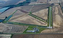
[编辑]奥尔迈拉市机场是一个位于阿肯色县内的公用机场。该机场距离奥尔迈拉中央商务区以西三海里(6公里)。[7]
奥尔迈拉市机场的面积为640英亩(260公顷),其海拔为211英尺(64米)。该机场拥有两条沥青铺跑道:18/36跑道长3,496英尺(1,066米),阔50英尺(15米);而10/28跑道则长3,000英尺(914 米),阔50英尺(15米)。于2007年6月30日至2008年6月30日期间,该机场总计有34,200次飞机升降,即平均每天93日。[7]
人口
[编辑]| 历史人口数 | |||
|---|---|---|---|
| 调查年 | 人口 | %± | |
| 1830年 | 1,426 | — | |
| 1840年 | 1,346 | −5.6% | |
| 1850年 | 3,245 | 141.1% | |
| 1860年 | 8,844 | 172.5% | |
| 1870年 | 8,268 | −6.5% | |
| 1880年 | 8,038 | −2.8% | |
| 1890年 | 11,432 | 42.2% | |
| 1900年 | 12,973 | 13.5% | |
| 1910年 | 16,103 | 24.1% | |
| 1920年 | 21,483 | 33.4% | |
| 1930年 | 22,300 | 3.8% | |
| 1940年 | 24,437 | 9.6% | |
| 1950年 | 23,665 | −3.2% | |
| 1960年 | 23,355 | −1.3% | |
| 1970年 | 23,347 | 0.0% | |
| 1980年 | 24,175 | 3.5% | |
| 1990年 | 21,653 | −10.4% | |
| 2000年 | 20,749 | −4.2% | |
| 2010年 | 19,019 | −8.3% | |
| 2012年估计 | 18,892 | −0.7% | |
| [8][9][10] | |||

根据2000年人口普查[11],阿肯色县拥有20,749居民、8,457住户和5,970家庭。[12]其人口密度为每平方英里21居民(每平方公里8居民)。[13]本县拥有9,672间房屋单位,其密度为每平方英里10间(每平方公里4间)。[14]而人口是由75.19%白人、23.36%黑人、0.21%土著、0.36%亚洲人、0.21%其他种族和0.66%混血构成。而西班牙裔或拉丁美洲人占了人口0.76%。[14]
在8,457住户中,有31.4%拥有一个或以上的儿童(18岁以下)、53%为夫妻、13.9%为单亲家庭、29.4%为非家庭、26.1%为独居、12.4%住户有同居长者。平均每户有2.41人,而平均每个家庭则有2.89人。在20,749居民中,有24.8%为18岁以下、8.3%为18至24岁、26.3%为25至44岁、24.4%为45至64岁以及16.2%为65岁以上。人口的年龄中位数为39岁,女子对男子的性别比为100:90.9。成年人的性别比则为100:86。[15]
本县的住户收入中位数为$30,316,而家庭收入中位数则为$36,472。男性的收入中位数为$28,914 ,而女性的收入中位数则为$21,127 ,人均收入为$16,401。约14.1%家庭和17.8%人口在贫穷线以下,包括24.8%儿童(18岁以下)及15.5%长者(65岁以上)。[15]
于2000年,本县最大的宗教派别为福音派新教(10,229信徒)和传统新教(3,593信徒)。[16]而最大宗教团体则是美南浸信会(5,103信徒)和联合卫理公会(2,750信徒)。[16]
参考文献
[编辑]- ^ "Pictorial" (1890), p. 823.
- ^ Arkansas State Highway and Transportation Department in cooperation with the U.S. Department of Transportation. Arkansas County Polygons (SHP file) (地图). Arkansas GIS Office. 2014-10-16 [January 1, 2017]. (原始内容存档于2021-05-23).
- ^ United States Census Bureau, American FactFinder (页面存档备份,存于互联网档案馆), 2010 Census figures. Retrieved March 23, 2011.
- ^ Find a County. National Association of Counties. [2011-06-07].
- ^ US Board on Geographic Names. United States Geological Survey. 2007-10-25 [2008-01-31].
- ^ Census 2000 U.S. Gazetteer Files: Counties. United States Census. [2011-02-13]. (原始内容存档于2012-06-06).
- ^ 7.0 7.1 M73的美国联邦航空局机场记录 (PDF). Federal Aviation Administration. Effective 11 February 2010.
- ^ 1900-1990 census data. United States Census Bureau. [2013-05-06]. (原始内容存档于2013-06-18).
- ^ American FactFinder. Factfinder2.census.gov. [2013-02-16]. (原始内容存档于2013-09-11).
- ^ University of Virginia Library. Mapserver.lib.virginia.edu. [2013-02-16]. (原始内容存档于2012-08-11).
- ^ American FactFinder. United States Census Bureau. [2008-01-31].
- ^ (英文)Population Profile of the United States: 2000 (页面存档备份,存于互联网档案馆)
- ^ Statistical profile of Alger County, Michigan 互联网档案馆的存档,存档日期2012-04-07., United States Census Bureau, Census 2000
- ^ 14.0 14.1 (英文)State and County QuickFacts (页面存档备份,存于互联网档案馆)
- ^ 15.0 15.1 (英文)American FactFinder Archive.is的存档,存档日期2020-02-12
- ^ 16.0 16.1 County Membership Reports. thearda.com. [2011-08-22]. (原始内容存档于2018-07-02).
| |||||||||||||||||||||||||||||||||||
| |||||||||||||||||||||||||
Text is available under the CC BY-SA 4.0 license; additional terms may apply.
Images, videos and audio are available under their respective licenses.


