塞维尔县 (阿肯色州)
| 阿肯色州塞维尔县 | |
|---|---|
| 地图 | |
 塞维尔县于阿肯色州内的地理位置 | |
 美国阿肯色州的地理位置 | |
| 统计资料 | |
| 成立时间 | 1828年10月17日 |
| 县治 | 德昆 |
| 面积 - 全部 | 581平方英里(1,500平方千米) |
| - 陆地 | 564平方英里(1,460平方千米) |
| - 水域 | 17平方英里(44平方千米),2.99% |
| 人口 - 2010年 | 17058人 |
| - 密度 | 11.67人/km² |
| 网站 | www.seviercounty-ar.gov |
塞维尔县(英语:Sevier County)是美国阿肯色州西南部的一个县,该县西邻奥克拉荷马州,面积1,506平方公里。根据2010年人口普查,该县共有人口17,058人。[1]该县县治为德昆(De Queen)。[2]该县亦是一个禁酒的县。[3]
历史
[编辑]
塞维尔县于1828年10月17日根据立法授权成立,是自亨普斯特德县和米勒县成立的,亦是阿肯色州第16个成立的县。[4]5天后,立法机关扩大了本县的版图,将红河以南的土地纳入本县内。[5]本县的政府于11月1日正式生效。[6]县名纪念联邦参议员、驻墨西哥大使安布罗西·H·塞维尔 (Ambrose Hundley Sevier)。[7]
自本县成立以来,县治已经更换了好几次。本县的第一个县治为帕拉克利夫特(Paraclifta)。于1871年,洛克家族(Lockes)捐出了120英亩(0.49平方千米)土地予塞维尔县政府。作为报答,县政府将县治迁往洛克堡(Lockesburg)。于1905年,县政府将县治迁往德昆。
地理
[编辑]根据2000年人口普查,塞维尔县的总面积为581.35平方英里(1,505.7平方千米),其中有563.94平方英里(1,460.6平方千米),即97.01%为陆地;17.41平方英里(45.1平方千米),即2.99%为水域。[8]塞维尔县有着“湖泊之地”(The Land of Lakes)、“水果鲜花之地”(The Land of Fruits and Flowers)和“友好人们的家”(The Home of Friendly People)的绰号。[9]本县有“湖泊之地”的绰号是因为本县拥有五个半径约为35-英里(56-千米)的湖泊。此外,本县亦拥有五条河流和很多山区溪流和森林。[10]
主要公路
[编辑]毗邻县
[编辑]国家保护区
[编辑]- 池溪国家野生动物保护区
人口
[编辑]| 历史人口数 | |||
|---|---|---|---|
| 调查年 | 人口 | %± | |
| 1830年 | 634 | — | |
| 1840年 | 2,810 | 343.2% | |
| 1850年 | 4,240 | 50.9% | |
| 1860年 | 10,516 | 148.0% | |
| 1870年 | 4,492 | −57.3% | |
| 1880年 | 6,192 | 37.8% | |
| 1890年 | 10,072 | 62.7% | |
| 1900年 | 16,339 | 62.2% | |
| 1910年 | 16,616 | 1.7% | |
| 1920年 | 18,301 | 10.1% | |
| 1930年 | 16,364 | −10.6% | |
| 1940年 | 15,248 | −6.8% | |
| 1950年 | 12,293 | −19.4% | |
| 1960年 | 10,156 | −17.4% | |
| 1970年 | 11,272 | 11.0% | |
| 1980年 | 14,060 | 24.7% | |
| 1990年 | 13,637 | −3.0% | |
| 2000年 | 15,757 | 15.5% | |
| 2010年 | 17,058 | 8.3% | |
| 2012年估计 | 17,177 | 0.7% | |
2012年人口估计[12] | |||

根据2000年人口普查[13],塞维尔县拥有15,757居民、5,708住户和4,223家庭。[14]其人口密度为每平方英里28居民(每平方公里11居民)。[15]本县拥有6,434间房屋单位,其密度为每平方英里11间(每平方公里4间)。[16]而人口是由79.61%白人、4.94%黑人、1.82%土著、0.13%亚洲人、0.06%太平洋岛民、11.84%其他种族和1.61%混血构成。而西班牙裔或拉丁美洲人占了人口19.72%。[17]约17.32%人口的母语为西班牙语。[18]
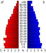
在5,708住户中,有36.4%拥有一个或以上的儿童(18岁以下)、59.3%为夫妻、10%为单亲家庭、26%为非家庭、22.8%为独居、11%住户有同居长者。平均每户有2.73人,而平均每个家庭则有3.19人。在15,757居民中,有28.2%为18岁以下、9.5%为18至24岁、27.7%为25至44岁、21.3%为45至64岁以及13.2%为65岁以上。人口的年龄中位数为34岁,女子对男子的性别比为100:99.1。成年人的性别比则为100:97。[19]
本县的住户收入中位数为$30,144,而家庭收入中位数则为$34,560。男性的收入中位数为$25,709,而女性的收入中位数则为$17,666,人均收入为$14,122。约14.4%家庭和19.2%人口在贫穷线以下,包括26.9%儿童(18岁以下)及14.2%长者(65岁以上)。[19]
参考文献
[编辑]- ^ 2010 census data 互联网档案馆的存档,存档日期2011-07-06.
- ^ Find a County. National Association of Counties. [2011-06-07].
- ^ Winn, Russell and Giacopassi, David. Effects of county-level alcohol prohibition on motor vehicle accidents. Social Science Quarterly, 1993, 74, 783–792.
- ^ Strickland, Rex W. Miller County, Arkansas Territory: The Frontier That Men Forgot. Chronicles of Oklahoma (Oklahoma Historical Society). March 1941, 19 (1): 43 [2012-05-13]. (原始内容存档于2012-07-28). (footnote 17)
- ^ Strickland, Rex W. Miller County, Arkansas Territory: The Frontier That Men Forgot. Chronicles of Oklahoma (Oklahoma Historical Society). March 1941, 19 (1): 43 [2012-05-13]. (原始内容存档于2012-07-28).
- ^ Kane, Joseph Nathan; Aiken, Charles Curry. The American Counties: Origins of County Names, Dates of Creation, and Population Data, 1950-2000 5th. Oxford, England: Scarecrow Press. 2005: 274. ISBN 0810850362.
- ^ Kane, J. N. and C. C. Aiken. The American Counties: Origins of County Names Dates of Creation and Population Data 1950-2000. Lanham, MD.: Scarecrow Press, 2005.
- ^ Census 2000 U.S. Gazetteer Files: Counties. United States Census. [2011-02-13]. (原始内容存档于2012-06-06).
- ^ Register at De Queen, Sevier County, Arkansas, United States. [2013-10-01]. (原始内容存档于2016-03-05).
- ^ Soil Survey of Sevier County, Arkansas 互联网档案馆的存档,存档日期2013-02-16.
- ^ U.S. Decennial Census. Census.gov. [July 6, 2013]. (原始内容存档于2015-05-12).
- ^ Annual Estimates of the Resident Population: April 1, 2010 to July 1, 2012. Census.gov. [July 6, 2013]. (原始内容存档于2016-02-05).
- ^ American FactFinder. United States Census Bureau. [2008-01-31].
- ^ (英文)Population Profile of the United States: 2000 (页面存档备份,存于互联网档案馆)
- ^ Statistical profile of Alger County, Michigan 互联网档案馆的存档,存档日期2012-04-07., United States Census Bureau, Census 2000
- ^ (英文)State and County QuickFacts 互联网档案馆的存档,存档日期2004-04-01.
- ^ (英文)Census 2000 gateway (页面存档备份,存于互联网档案馆)
- ^ MLA Language Map Data Center. [2022-03-16]. (原始内容存档于2015-06-10).
- ^ 19.0 19.1 (英文)American FactFinder Archive.is的存档,存档日期2020-02-12
外部链接
[编辑]34°00′N 94°15′W / 34°N 94.25°W
| ||||||||||||||||||||||||||||||
| |||||||||||||||||||||||||
| |||||||||||||||||
Text is available under the CC BY-SA 4.0 license; additional terms may apply.
Images, videos and audio are available under their respective licenses.


