锡林浩特市
| 锡林浩特市 ᠰᠢᠯᠢ ᠶᠢᠨ ᠬᠣᠲᠠ | |
|---|---|
| 县级市 | |
 锡林浩特市俯瞰 | |
 | |
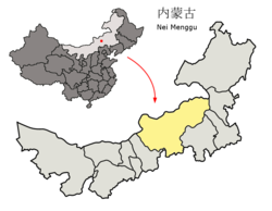
 锡林郭勒盟的地理位置 | |
| 坐标:43°56′02″N 116°05′10″E / 43.934°N 116.086°E | |
| 国家 | |
| 隶属行政区 | 内蒙古自治区锡林郭勒盟 |
| 设立 | 1983年10月 |
| 语源 | 音译自蒙古语,意为“高原的城” |
| 政府驻地 | 希日塔拉街道 |
| 下级行政区 | |
| 面积 | |
| • 总计 | 14,780.18 平方公里(5,706.66 平方英里) |
| 人口(2020) | |
| • 总计 | 34.99万人 |
| • 密度 | 16.85人/平方公里(43.6人/平方英里) |
| 时区 | 北京时间(UTC+8) |
| 邮政编码 | 026000 |
| 电话区号 | 0479 |
| 行政区划代码 | 152502 |
| 旧称 | 阿巴哈纳尔旗 |
| 国内生产总值 | ¥143.4亿 |
| • 人均 | ¥74299 |
| 网站 | 锡林浩特市政务门户网站 |
锡林浩特市(蒙古语:ᠰᠢᠯᠢ
ᠶᠢᠨ
ᠬᠣᠲᠠ,西里尔字母:Шилийн хот)是中华人民共和国内蒙古自治区锡林郭勒盟下辖的一个县级市,亦是该盟的首府。锡林浩特蒙古语意为“丘陵的城”,原名阿巴哈纳尔旗。市人民政府驻团结大街16号。
锡林郭勒市位于东经116°,北纬°44度附近,内蒙古自治区中东部内蒙古高原内部的锡林郭勒草原腹地。东邻西乌珠穆沁旗,南接正兰旗,东南与赤峰市的克什克腾旗接壤,西依阿巴嘎旗,北同东乌珠穆沁旗为邻。面积14902平方公里,人口11万。以汉族和蒙古族为主。工业有畜产品加工、民族用品工业等。土特产绒毛、蘑菇等。自然矿产资源有铁矿、铜矿、锡矿、煤矿和石油。有207国道和303国道通过。并有铁路与集通铁路连接[1]。
地理
地形地貌
地势南高北低。北部为平缓的波状平原,南部多为浅山丘陵。海拔1000 - 1300米。汗乌拉1699.9米,为市内最高点。锡林郭勒河贯穿中部,形成河间盆地,间有沼泽,较大的湖泊有查干淖尔、巴彦呼热淖尔、巴彦淖尔。分为4个地貌单元。即高平原地区、熔岩台地区、低缓丘陵地和沙丘沙漠地区。
气候
锡林浩特气候属大陆性半干旱气候,季风影响。日照满高,降雨集中在夏季。1月平均气温−18.8℃,7月平均气温21.2℃,年平均气温2.6℃。
| 1981−2010年间锡林浩特市的平均气象数据 | |||||||||||||
|---|---|---|---|---|---|---|---|---|---|---|---|---|---|
| 月份 | 1月 | 2月 | 3月 | 4月 | 5月 | 6月 | 7月 | 8月 | 9月 | 10月 | 11月 | 12月 | 全年 |
| 平均高温 °C(°F) | −12.1 (10.2) |
−6.7 (19.9) |
2.3 (36.1) |
13.4 (56.1) |
20.8 (69.4) |
25.9 (78.6) |
27.9 (82.2) |
26.5 (79.7) |
20.9 (69.6) |
11.7 (53.1) |
0.0 (32.0) |
−9.3 (15.3) |
10.1 (50.2) |
| 日均气温 °C(°F) | −18.8 (−1.8) |
−14.2 (6.4) |
−5.2 (22.6) |
5.7 (42.3) |
13.5 (56.3) |
19.2 (66.6) |
21.6 (70.9) |
19.8 (67.6) |
13.3 (55.9) |
4.1 (39.4) |
−7.0 (19.4) |
−15.5 (4.1) |
3.0 (37.5) |
| 平均低温 °C(°F) | −23.9 (−11.0) |
−20.2 (−4.4) |
−11.6 (11.1) |
−1.5 (29.3) |
5.9 (42.6) |
12.3 (54.1) |
15.7 (60.3) |
13.6 (56.5) |
6.6 (43.9) |
−2.1 (28.2) |
−12.4 (9.7) |
−20.4 (−4.7) |
−3.2 (26.3) |
| 平均降水量 mm(吋) | 2.0 (0.08) |
2.1 (0.08) |
5.0 (0.20) |
7.6 (0.30) |
23.6 (0.93) |
45.3 (1.78) |
72.9 (2.87) |
61.6 (2.43) |
25.1 (0.99) |
10.0 (0.39) |
5.1 (0.20) |
3.2 (0.13) |
263.5 (10.38) |
| 平均降水天数(≥ 0.1 mm) | 4.1 | 3.8 | 4.5 | 3.9 | 5.9 | 10.9 | 14.0 | 11.6 | 6.7 | 4.7 | 4.2 | 4.3 | 78.6 |
| 平均相对湿度(%) | 72 | 67 | 54 | 38 | 39 | 48 | 59 | 60 | 53 | 52 | 60 | 70 | 56 |
| 月均日照时数 | 205.0 | 213.7 | 262.1 | 271.6 | 298.2 | 287.5 | 276.9 | 273.3 | 254.5 | 239.7 | 199.7 | 187.8 | 2,970 |
| 可照百分比 | 72 | 73 | 72 | 68 | 66 | 63 | 59 | 63 | 68 | 70 | 69 | 68 | 67 |
| 数据来源:中国气象局(1971−2000年间的降水天数和日照数据)[2][3] | |||||||||||||
行政区划
希日塔拉街道、宝力根街道、杭盖街道、楚古兰街道、额尔敦街道、南郊街道、巴彦查干街道、巴彦锡勒街道、阿尔善宝拉格镇、宝力根苏木、朝克乌拉苏木、巴彦宝拉格苏木、锡林郭勒盟经济技术开发区、白音库伦牧场、贝力克牧场和毛登牧场。
人口
根据第七次人口普查数据,截至2020年11月1日零时,锡林浩特市常住人口为349953人。[5]
交通
参考文献
- ^ 锡市概况. 锡林浩特市人民政府. 2023-03-13 [2023-05-17]. (原始内容存档于2023-05-17).
- ^ 中国气象数据网 - WeatherBk Data. 中国气象局. [2020-04-15].
- ^ 中国地面国际交换站气候标准值月值数据集(1971-2000年). 中国气象局.
- ^ 2023年锡林浩特市统计用区划代码和城乡划分代码. 中华人民共和国国家统计局. 2023-06-30 (中文(中国大陆)).
- ^ 中國: 内蒙古自治区 (地级行政、县级行政区) - 人口统计,图表和地图. www.citypopulation.de. [2023-09-18].
外部链接
| ||||||||||||||||||||||||||||||||
| ||||||||||||||||||||||||||||||||||||||||||||||||||||||||||||||||||||||||||||||||||||||||||||||||||||||||||||||||||||||||||||||||||||||||||||||||||||||||||||||||||||||||||||||||||||||
| |||||||||||||||||||||||||||||||||||||||||||||||||||||||||||||||||||||||||||||||||||||
Text is available under the CC BY-SA 4.0 license; additional terms may apply.
Images, videos and audio are available under their respective licenses.


