For faster navigation, this Iframe is preloading the Wikiwand page for 门仔塘.

门仔塘

此条目没有列出任何参考或来源。 (2014年6月12日)维基百科所有的内容都应该可供查证。请协助补充可靠来源改善这篇条目。无法查证的内容可能会因为异议提出而被移除。
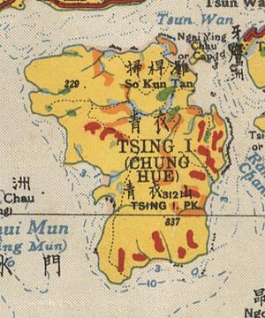
青衣岛牙鹰洲之间的门仔塘在1936年地图的位置。

门仔塘(英语:Mun Tsai Tong,亦作Moon Tsai Tong)是昔日香港新界蓝巴勒海峡的一个渔港兼避风塘,位于青衣岛牙鹰洲之间,即现时的长安邨长发邨一带。门仔塘有东面和北面两个缺口,连接蓝巴勒海峡,现在已被填海成为陆地。

历史

门仔塘虽然自古以来是避风塘,但全盛时期是1960年代。当时葵涌被大规模填海以发展荃湾新市镇,整个醉酒湾也成为陆地。本来居住于该湾的水上人,只好到对面的青衣岛岸边的门仔塘停泊船只。而美国经援协会于门仔塘附近的山丘协助渔民建屋,后来交由香港明爱发展。这些乡村便是现时青衣城对面一带的渔民村和圣保禄村。此外,香港鱼类统营处亦于山丘顶部兴建一间青衣渔民子弟学校,为渔民子女提供教育。

踏入1980年代,新市镇的发展延伸至青衣岛北部,整个门仔塘被填平。因此,政府于1983年将该处渔民安置上楼,当中很多人迁往长青邨青桃楼,该楼是专门为这批渔民而建的。

外部链接

{{bottomLinkPreText}} {{bottomLinkText}}
门仔塘
Listen to this article

This browser is not supported by Wikiwand :(
Wikiwand requires a browser with modern capabilities in order to provide you with the best reading experience.
Please download and use one of the following browsers:

This article was just edited, click to reload
This article has been deleted on Wikipedia (Why?)

Back to homepage

Please click Add in the dialog above
Please click Allow in the top-left corner,
then click Install Now in the dialog
Please click Open in the download dialog,
then click Install
Please click the "Downloads" icon in the Safari toolbar, open the first download in the list,
then click Install
{{::$root.activation.text}}

Install Wikiwand

Install on Chrome Install on Firefox
Don't forget to rate us

Tell your friends about Wikiwand!

Gmail Facebook Twitter Link

Enjoying Wikiwand?

Tell your friends and spread the love:
Share on Gmail Share on Facebook Share on Twitter Share on Buffer

Our magic isn't perfect

You can help our automatic cover photo selection by reporting an unsuitable photo.

This photo is visually disturbing This photo is not a good choice

Thank you for helping!


Your input will affect cover photo selection, along with input from other users.

X

Get ready for Wikiwand 2.0 🎉! the new version arrives on September 1st! Don't want to wait?