南咸海
| 南咸海 | |
|---|---|
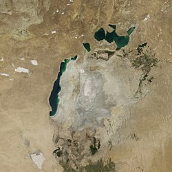
 2014年的咸海 | |
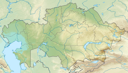
| 位置 | 中亚哈萨克斯坦和乌兹别克斯坦 |
| 坐标 | 45°00′N 58°30′E / 45°N 58.5°E |
| 湖泊类型 | 内流盆地、天然湖泊 |
| 主要流入 | 地下水 (曾有阿姆河注入) |
| 所在国家 | 哈萨克斯坦、乌兹别克斯坦 |
| 表面积 | 西咸海: 3,500 km2(1,350 sq mi)(2005) 东咸海:42,100 km2(16,250 sq mi)(1989) |
| 平均深度 | 14—15米(46—49英尺)(2005) |
| 最大深度 | 37—40米(121—131英尺)(2005) |
| 表面海拔 | 29米(95英尺)(2007) |
| 参考 | [1] |
南咸海原是咸海的南部,1987年因水域萎缩而与咸海北部分离。 2003年,南咸海再分裂为东咸海和西咸海,由一条狭窄的水道连接。2005年,哈萨克斯坦在北咸海修筑堤坝,阻断了流入南咸海的水流。 2008年,东咸海再次分裂,2009年5月几乎完全干涸,只剩下北咸海和西咸海之间的巴尔萨克尔梅斯湖,阿拉尔库姆沙漠也随之扩大[2][3]。2010年,它再次被融雪部分填满[4],到2014年再次干涸。西咸海有地下水的补充,完全干涸机会低[5]。
背景
20世纪60年代开始,苏联决定将注入咸海的两条河流阿姆河和锡尔河改道,以灌溉哈萨克斯坦和乌兹别克斯坦的棉花和农作物,咸海开始萎缩。 1987年,湖水加速流失,咸海分裂为南咸海和北咸海[6]。
盐度
2007年,西咸海盐度为70公克/升,东咸海则为100公克/升。当水位低于海拔29米的连结水道时,盐度相差将会扩大[7]。
目前情况
西咸海的面积在2700-3500平方公里之间,平均深度为14-15米,最大深度为37-40米[7]。东咸海在 2009年夏天完全干涸,但偶尔会在春天融雪期间暂时被水填充。
参考
- ^ Seen from Space – South Aral Sea shrinking but North Aral Sea expanding. EORC. [31 May 2017].
- ^ Harald Frater. scinexx | Aralsee: Ostbecken ist jetzt Wüste: Satellitenaufnahmen dokumentieren dramatische Austrocknung der letzen Jahre – Wüsten, Aralsee, Desertifikation, Wasser, Bewässerung, Landschaft, Landwirtschaft, Flüsse. Scinexx.de. 10 August 2009 [2013-09-01].
- ^ Freshwater Ecoregions of the World. Feow.org. 2013-02-26 [2013-09-01]. (原始内容存档于19 February 2012).
- ^ The Shrinking Aral Sea Recovers : Image of the Day. Earthobservatory.nasa.gov. 30 October 2010 [2013-09-01]. doi:10.1111/j.1440-1770.2010.00437.x.
- ^ Jarsjö, Jerker; Destouni, Georgia. Groundwater discharge into the Aral Sea after 1960. Journal of Marine Systems. 2004, 47 (1–4): 109–120. Bibcode:2004JMS....47..109J. doi:10.1016/j.jmarsys.2003.12.013.
- ^ Craig Murray (2007). Dirty Diplomacy. Scribner.
- ^ 7.0 7.1 Peter O. Zavialov, 2005, Physical oceanography of the dying Aral Sea, p 112
- ^ https://www.weforum.org/agenda/2020/02/aral-sea-lake-water-nature-human-impact/ Satellite image of 2018
- ^ https://eurasianet.org/northern-arals-promise-stunted-by-dam-height-international-disputes Satellite image of 2020
[[Category:烏茲別克斯坦湖泊]] [[Category:哈薩克斯坦湖泊]] [[Category:鹹海]] [[Category:维基数据存在坐标数据的页面]]
Text is available under the CC BY-SA 4.0 license; additional terms may apply.
Images, videos and audio are available under their respective licenses.


