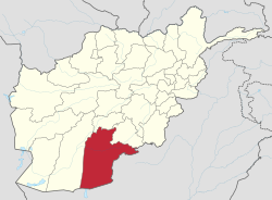
จังหวัดกันดะฮาร์
กันดะฮาร์ کندهار | |
|---|---|
| สมญา: Loy kandahar | |
 ที่ตั้งของกันดะฮาร์ในประเทศอัฟกานิสถาน | |
| พิกัด (เมืองหลัก): 31°00′N 65°30′E / 31.0°N 65.5°E | |
| ประเทศ | |
| เมืองหลัก | กันดะฮาร์ |
| การปกครอง | |
| • ผู้ว่าราชการ | Yousaf Wafa [1] |
| พื้นที่[2] | |
| • ทั้งหมด | 54,844 ตร.กม. (21,175 ตร.ไมล์) |
| ประชากร (2021)[3] | |
| • ทั้งหมด | 1,431,876 คน |
| • ความหนาแน่น | 26 คน/ตร.กม. (68 คน/ตร.ไมล์) |
| เขตเวลา | UTC+4:30 (เวลากลางอัฟกานิสถาน) |
| รหัสพื้นที่ | AF-KAN |
กันดะฮาร์ (ปาทาน: کندھار; ดารี: قندهار; บาโลจ: قندہار) เป็นหนึ่งใน 34 จังหวัดของอัฟกานิสถาน ตั้งอยู่ทางภาคใต้ของประเทศ มีพรมแดนติดต่อกับแคว้นบาโลชิสถานของประเทศปากีสถาน เมืองหลักของจังหวัดคือกันดะฮาร์ เป็นเมืองที่ใหญ่ทึ่สุดอันดับสองของประเทศ ตั้งอยู่บนแม่น้ำอาร์ฆานดาบ
จังหวัดประกอบด้วย 18 อำเภอ มีประชากรราว 1,431,876 คน มากเป็นอันดับหกของประเทศ ซึ่งประชากรส่วนใหญ่อาศัยอยู่ในเขตชนบท[3] ชาติพันธุ์ส่วนใหญ่เป็นชาวปาทาน[4]
ประชากร
[แก้]จากข้อมูลของสำนักงานสถิติและข้อมูลแห่งชาติ (NSIA) พบว่ามีประชากรทั้งหมดของจังหวัดประมาณ 1.43 ล้านคน[3] ชาวปาทานเป็นประชากรส่วนใหญ่ในจังหวัด รองลงมาคือ ชาวบาโลจ ชาวฮาซารา และชาวทาจิก[4] ภาษาหลักที่ใช้กันทั่วทั้งจังหวัดคือ ภาษาปาทานและภาษาบาโลจ[2] ประชากรบางส่วนเข้าใจภาษาดารี โดยเฉพาะอย่างยิ่งในเมืองกันดาฮาร์ ที่มีการส่งเสริมการเรียนรู้ภาษาดารีเป็นภาษาที่สองในโรงเรียนของรัฐ[5]
ดูเพิ่ม
[แก้]อ้างอิง
[แก้]- ↑ "Senior Officials Appointed in Kandahar". TOLOnews. January 3, 2021. สืบค้นเมื่อ 2021-02-18.
- ↑ 2.0 2.1 "Name of the Province: Kandahar". Islamic Republic of Afghanistan: President. สืบค้นเมื่อ 2021-02-04.
- ↑ 3.0 3.1 3.2 "Estimated Population of Afghanistan 2021-22" (PDF). nsia.gov.af. National Statistic and Information Authority (NSIA). April 2021. คลังข้อมูลเก่าเก็บจากแหล่งเดิม (PDF)เมื่อ 2021-06-24. สืบค้นเมื่อ June 30, 2021.
- ↑ 4.0 4.1 "Kandahar Provincial Overview". Naval Postgraduate School (NPS). สืบค้นเมื่อ 2021-02-18.
- ↑ هنریار, ارشاد (2019-05-26). "فارسی زبانهای قندهار؛ پیشتاز زرگری و رایگیری". BBC News فارسی (ภาษาเปอร์เซีย). สืบค้นเมื่อ 2020-07-26.
หนังสืออ่านเพิ่ม
[แก้]- Vogelsang, W. (1985). Early historical Arachosia in South-east Afghanistan; Meeting-place between East and West.
- Dupree, Louis. (1973) Afghanistan. Princeton: Princeton University Press.
- Rashid, Ahmed. (2000) Taliban: Militant Islam, Oil, and Fundamentalism in Central Asia. New Haven, CT: Yale University Press.
แหล่งข้อมูลอื่น
[แก้]| นานาชาติ | |
|---|---|
| ประจำชาติ | |
| อื่น ๆ | |
Text is available under the CC BY-SA 4.0 license; additional terms may apply.
Images, videos and audio are available under their respective licenses.
