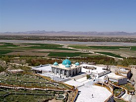
กันดะฮาร์
กันดะฮาร์
| |
|---|---|
นคร | |
บนลงล่างและซ้ายไปขวา: ทิวทัศน์เมืองกันดะฮาร์, สุสานมีร์วาอิส โฮตัก, สุสานอาห์มัด ชาห์ ดูร์รานี, ภาพมุมสูงของสุสานบาบาวาลี และแม่น้ำอาร์กันดาบอยู่ไกล ๆ | |
| พิกัด: 31°37′N 65°43′E / 31.617°N 65.717°E | |
| ประเทศ | |
| จังหวัด | กันดะฮาร์ |
| อำเภอ | กันดะฮาร์ |
| การปกครอง | |
| • นายกเทศมนตรี | Mohammad Yousaf Wafa |
| พื้นที่ | |
| • ทั้งหมด | 273.37 ตร.กม. (105.55 ตร.ไมล์) |
| ความสูง | 1,010 เมตร (3,310 ฟุต) |
| ประชากร (ค.ศ. 2021) | |
| • ทั้งหมด | 651,484[1] คน |
| เขตเวลา | UTC+4:30 (เวลามาตรฐานอัฟกานิสถาน) |
| เว็บไซต์ | www |
กันดะฮาร์ (อังกฤษ: Kandahar; ปาทาน: کندهار, อักษรโรมัน: kandahār; ดารี: قندهار, อักษรโรมัน: qandahār) เป็นเมืองที่ใหญ่เป็นอันดับที่ 2 ของอัฟกานิสถาน รองจากกรุงคาบูล ข้อมูลปี ค.ศ. 2015 มีประชากรทั้งหมด 614,118 คน[2] ตั้งอยู่ในจังหวัดกันดะฮาร์ สูง 1,010 เมตรจากระดับน้ำทะเล แม่น้ำที่สำคัญได้แก่ แม่น้ำอาร์กันดับ
ภูมิศาสตร์
[แก้]แม่น้ำ Arghandab ไหลผ่านทางตะวันตกของกันดะฮาร์ นครนี้แบ่งออกเป็น 15 เขตและมีพื้นที่รวม 27,337 เฮกเตอร์[3] จำนวนผู้อยู่อาศัยในนครอยู่ที่ 61,902 คน[3]
ภูมิอากาศ
[แก้]กันดะฮาร์มีสภาพภูมิอากาศแบบทะเลทรายเขตร้อน (BWh)[4]
| ข้อมูลภูมิอากาศของกันดะฮาร์ (ค.ศ. 1964–1983) | |||||||||||||
|---|---|---|---|---|---|---|---|---|---|---|---|---|---|
| เดือน | ม.ค. | ก.พ. | มี.ค. | เม.ย. | พ.ค. | มิ.ย. | ก.ค. | ส.ค. | ก.ย. | ต.ค. | พ.ย. | ธ.ค. | ทั้งปี |
| อุณหภูมิสูงสุดที่เคยบันทึก °C (°F) | 25.0 (77) |
26.0 (78.8) |
36.5 (97.7) |
37.1 (98.8) |
43.0 (109.4) |
45.0 (113) |
46.5 (115.7) |
44.5 (112.1) |
41.0 (105.8) |
37.5 (99.5) |
31.5 (88.7) |
26.0 (78.8) |
46.5 (115.7) |
| อุณหภูมิสูงสุดเฉลี่ย °C (°F) | 12.2 (54) |
14.8 (58.6) |
21.6 (70.9) |
28.1 (82.6) |
34.1 (93.4) |
39.1 (102.4) |
40.2 (104.4) |
38.2 (100.8) |
34.0 (93.2) |
27.5 (81.5) |
21.0 (69.8) |
15.4 (59.7) |
27.2 (81) |
| อุณหภูมิเฉลี่ยแต่ละวัน °C (°F) | 5.1 (41.2) |
7.8 (46) |
13.9 (57) |
20.2 (68.4) |
25.4 (77.7) |
30.0 (86) |
31.9 (89.4) |
29.4 (84.9) |
23.5 (74.3) |
17.5 (63.5) |
11.0 (51.8) |
7.3 (45.1) |
18.58 (65.45) |
| อุณหภูมิต่ำสุดเฉลี่ย °C (°F) | 0.0 (32) |
2.4 (36.3) |
7.1 (44.8) |
12.3 (54.1) |
15.8 (60.4) |
19.5 (67.1) |
22.5 (72.5) |
20.0 (68) |
13.5 (56.3) |
8.5 (47.3) |
3.3 (37.9) |
1.0 (33.8) |
10.5 (50.9) |
| อุณหภูมิต่ำสุดที่เคยบันทึก °C (°F) | −12.1 (10.2) |
-10.0 (14) |
−4.8 (23.4) |
2.0 (35.6) |
2.4 (36.3) |
8.5 (47.3) |
13.5 (56.3) |
9.0 (48.2) |
5.2 (41.4) |
-2.2 (28) |
−9.3 (15.3) |
−11.4 (11.5) |
−12.1 (10.2) |
| หยาดน้ำฟ้า มม (นิ้ว) | 54.0 (2.126) |
42.0 (1.654) |
41.1 (1.618) |
18.7 (0.736) |
2.2 (0.087) |
0 (0) |
2.3 (0.091) |
1.0 (0.039) |
0 (0) |
2.3 (0.091) |
7.0 (0.276) |
20.0 (0.787) |
190.6 (7.504) |
| ความชื้นร้อยละ | 58 | 59 | 50 | 41 | 30 | 23 | 25 | 25 | 24 | 29 | 40 | 52 | 38 |
| วันที่มีหยาดน้ำฟ้าโดยเฉลี่ย | 6 | 6 | 6 | 4 | 1 | 0 | 0 | 0 | 0 | 1 | 2 | 3 | 29 |
| จำนวนชั่วโมงที่มีแดด | 198.4 | 183.6 | 235.6 | 255.0 | 347.2 | 369.0 | 341.0 | 337.9 | 324.0 | 306.9 | 264.0 | 217.0 | 3,379.6 |
| แหล่งที่มา: NOAA (1964–1983)[5] | |||||||||||||
อ้างอิง
[แก้]- ↑ "Estimated Population of Afghanistan 2021-22" (PDF). National Statistic and Information Authority (NSIA). April 2021. คลังข้อมูลเก่าเก็บจากแหล่งเดิม (PDF)เมื่อ 24 June 2021. สืบค้นเมื่อ June 21, 2021.
- ↑ "The State of Afghan Cities report2015". คลังข้อมูลเก่าเก็บจากแหล่งเดิมเมื่อ 31 October 2015.
- ↑ 3.0 3.1 "The State of Afghan Cities report 2015". คลังข้อมูลเก่าเก็บจากแหล่งเดิมเมื่อ 31 October 2015. สืบค้นเมื่อ 22 October 2015.
- ↑ [1] เก็บถาวร 14 กุมภาพันธ์ 2010 ที่ เวย์แบ็กแมชชีน (ในภาษารัสเซีย)
- ↑ "Kandahar Climate Normals 1964–1983". National Oceanic and Atmospheric Administration. เก็บจากแหล่งเดิมเมื่อ 20 September 2022. สืบค้นเมื่อ 26 December 2012.
บรรณานุกรม
[แก้]- Dupree, Nancy Hatch (1977) [1st Edition: 1970]. An Historical Guide to Afghanistan (2nd Edition, Revised and Enlarged ed.). Afghan Tourist Organization.
- Hill, John E. 2004. The Peoples of the West from the Weilue 魏略 by Yu Huan 魚豢: A Third Century Chinese Account Composed between 239 and 265 CE. Draft annotated English translation.
- Hill, John E. (2009) Through the Jade Gate to Rome: A Study of the Silk Routes during the Later Han dynasty, 1st to 2nd centuries CE. BookSurge, Charleston, South Carolina. ISBN 978-1-4392-2134-1.
- Frye, Richard N. (1963). The Heritage of Persia. World Publishing company, Cleveland, Ohio. Mentor Book edition, 1966.
- Toynbee, Arnold J. (1961). Between Oxus and Jumna. London. Oxford University Press.
- Willem Vogelsang (1985). "Early historical Arachosia in South-east Afghanistan; Meeting-place between East and West." Iranica antiqua, 20 (1985), pp. 55–99.
- Wood, Michael (1997). In the Footsteps of Alexander the Great: A Journey from Greece to Asia. University of California Press. ISBN 0-520-23192-9
แหล่งข้อมูลอื่น
[แก้]- Map of Kandahar, from Afghanistan Information Management Services
| นานาชาติ | |
|---|---|
| ประจำชาติ | |
| ภูมิศาสตร์ | |
| อื่น ๆ | |
Text is available under the CC BY-SA 4.0 license; additional terms may apply.
Images, videos and audio are available under their respective licenses.


