คอร์นวอลล์
คอร์นวอลล์ | |||||||||||||||||||||||||||||||||||||||||||||||||
|---|---|---|---|---|---|---|---|---|---|---|---|---|---|---|---|---|---|---|---|---|---|---|---|---|---|---|---|---|---|---|---|---|---|---|---|---|---|---|---|---|---|---|---|---|---|---|---|---|---|
 (ธงนักบุญไพริน) | |||||||||||||||||||||||||||||||||||||||||||||||||
| คำขวัญ: Onen hag oll (ภาษาอังกฤษ: One and all) | |||||||||||||||||||||||||||||||||||||||||||||||||
 | |||||||||||||||||||||||||||||||||||||||||||||||||
| รัฐเอกราช | สหราชอาณาจักร | ||||||||||||||||||||||||||||||||||||||||||||||||
| ประเทศ | อังกฤษ | ||||||||||||||||||||||||||||||||||||||||||||||||
| ภูมิภาค | เซาท์เวสต์อิงแลนด์ | ||||||||||||||||||||||||||||||||||||||||||||||||
| เขตเวลา | UTC±00:00 (เวลามาตรฐานกรีนิช) | ||||||||||||||||||||||||||||||||||||||||||||||||
| • ฤดูร้อน (เวลาออมแสง) | UTC+01:00 (เวลาฤดูร้อนบริติช) | ||||||||||||||||||||||||||||||||||||||||||||||||
| |||||||||||||||||||||||||||||||||||||||||||||||||
คอร์นวอลล์ (อังกฤษ: Cornwall) หรือ แคร์นอว์ (คอร์นวอลล์: Kernow) เป็นเทศมณฑลแห่งหนึ่งของประเทศอังกฤษภายในสหราชอาณาจักร ตั้งอยู่ทางปลายแหลมด้านตะวันตกเฉียงใต้ของสหราชอาณาจักร ทางด้านเหนือและด้านตะวันตกจรดทะเลเคลติก ทางด้านใต้จรดช่องแคบอังกฤษ ด้านตะวันออกติดกับเทศมณฑลเดวอนโดยมีแม่น้ำเทมาร์เป็นเส้นแบ่งเขต คอร์นวอลล์มีประชากรรวมทั้งสิ้นประมาณ 526,300 คน ในเนื้อที่ 3,563 ตารางกิโลเมตร[1] ศูนย์กลางการปกครองตั้งอยู่ที่เมืองทรูโร
ดินแดนบริเวณคอร์นวอลล์เดิมเป็นที่ตั้งหลักแหล่งของชนยุคหินจากนั้นก็เป็นชนยุคสำริดและต่อมาในสมัยยุคเหล็กโดยชาวเคลต์ คอร์นวอลล์เป็นส่วนหนึ่งของบริเวณที่พูดภาษากลุ่มบริทอนิก (Brythonic languages) ที่ตัดขาดจากกลุ่มชนที่พูดภาษากลุ่มเดียวกันในเวลส์หลังจากยุทธการเดอรัม (Battle of Deorham) โดยมักขัดแย้งกับชาวแซกซันแห่งราชอาณาจักรเวสเซกซ์ที่พยายามขยายดินแดนเข้ามา ก่อนที่พระเจ้าแอเทลสตันจะกำหนดเขตแดนระหว่างชาวอังกฤษกับชาวคอร์นิชโดยใช้แม่น้ำทามาร์[2] คอร์นวอลล์รวมกับอังกฤษเมื่อใดไม่มีหลักฐานแน่นอน แต่การใช้ภาษาคอร์นิชยังคงใช้กันต่อมาจนคริสต์ศตวรรษที่ 18 การฟื้นฟูการใช้ภาษาคอร์นิชอีกครั้งมาเริ่มต้นขึ้นเมื่อคริสต์ศตวรรษ 20 และเพิ่มความนิยมมากขึ้นในคริสต์ทศวรรษที่ผ่านมา ในปัจจุบันคอร์นวอลล์ประสบปัญหาทางเศรษฐกิจเนื่องจากอุตสาหกรรมเหมืองดีบุกและอุตสาหกรรมการประมงเสื่อมโทรมลงและต้องหันมาพึ่งพาอุตสาหกรรมการท่องเที่ยวเป็นหลัก ดินแดนคอร์นวอลล์มีชื่อในทางที่มีภูมิทัศน์เป็นดินแดนสูงที่เป็นทุ่งที่มีแต่พืชพรรณเตี้ย ๆ เติบโตอยู่ที่เรียกว่า "ทุ่งมัวร์" (Moorland) และชายฝั่งทะเลที่น่าดูและอากาศที่อุ่นกว่าบริเวณอื่นของอังกฤษ
อ้างอิง
- ↑ "T 09: Quinary age groups and sex for local authorities in the United Kingdom; estimated resident population Mid-2006 Population Estimates". Office for National Statistics. สืบค้นเมื่อ 2008-05-23.
- ↑ Anglo-Saxon England, Professor F.M. Stenton, Clarendon Press, 1947, p.337)
แหล่งข้อมูลอื่น
![]() วิกิมีเดียคอมมอนส์มีสื่อเกี่ยวกับ คอร์นวอลล์
วิกิมีเดียคอมมอนส์มีสื่อเกี่ยวกับ คอร์นวอลล์
สมุดภาพ
-

-
 อ่าวและกำแพงทะเลที่เมืองเมวากิสซีย์ด้านใต้ของคอร์นวอลล์
 -
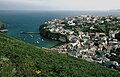
 อ่าวและเมืองเซนต์ไอฟส์
 -
 อ่าวใกล้ทินแทเจล
 -
 ซากปราสาที่ทินแทเจล
 -
 เมืองพอร์ตไอแซก
 -
 ปราสาทเพนเดนนิสใกล้แฟลมัท
 -
 บอสคาสเซิล
 -
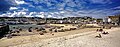
 เมืองลู
 -
 ลักษณะภูมิทัศน์ที่เรียกว่าทุ่งมัวร์


ค.ศ. 1974 – ค.ศ. 1996 ← | |
|---|---|
|
Text is available under the CC BY-SA 4.0 license; additional terms may apply.
Images, videos and audio are available under their respective licenses.
