Rajasthan
Rajasthan
રાજસ્થાની
ਰਾਜਸਥਾਨ | |
|---|---|
State of India | |
 Thar Desert in Rajasthan | |
| Nickname: City of Kings (Rajea da Sehar) | |
 Location of Rajasthan in the Republic of India | |
 Map of Rajasthan | |
| Country | |
| Region | West India |
| Government | |
| • Governor | Kalraj Mishra |
| • Chief Minister | Bhajan Lal Sharma |
| • Legislature | Unicameral (295* seats) |
| Area | |
| • Total | 342,239 km2 (132,139 sq mi) |
| • Land | 342,200 km2 (132,140 sq mi) |
| Population (2023) | |
| • Total | 90,621,012 |
| Demonym | Rajasthani |
| Time zone | UTC+05:30 (IST) |
| Official language | Rajasthani |
| Additional | Panjabi |
| ^* | |
Rajasthan (Rajasthani:રાજસ્થાની) (Panjabi: ਰਾਜਸਥਾਨ) is a state in northwestern India. It is the largest state of India in terms of land area; 132,150 mi² (342,269 km²). It is bigger than the Republic of the Congo but smaller than Germany. In traditional India geography it falls under the North Indian zone. The Thar Desert covers most parts of the state. The capital of the state is city of Jaipur.
Rajasthan is known for its rich history, vibrant culture, and barren landscapes. With a population of over 68 million(2011), Rajasthan is home to a diverse group of people, including the Rajputs, Jats, Meenas, and Bhils, who have contributed to the region’s unique identity and cultural heritage.
Before Indian independence the area of Rajasthan and parts of Eastern Pakistan were known as Rajputana; it consisted of many states of varying sizes ruled by Rajput kings.
Rajasthani Singers
[change | change source]- Ila Arun
- Rajnigandha Shekhawat
- Seema Mishra
- Meme Khan
- Swaroop Khan
- Rapperiya Baalam
- Satkeer
Districts
[change | change source]- Anupgarh
- Balotra
- Beawar
- Deeg
- Didwana-Kuchaman City
- Dudu
- Gangapur City
- Jaipur North
- Jaipur South
- Jodhpur East
- Jodhpur West
- Kekri
- Kotputli-Behror
- Khairthal
- Neemkathana
- Phalodi
- Salumbar
- Sanchore
- Shahpura (Bhilwara)
Divisions
[change | change source]- Barmer
- Chittaurgarh
- Bhilwara
- Nagaur
- Sawai madhopur
Provincial symbols of Rajasthan
[change | change source]-
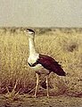 Provincial bird of Rajasthan
 -
 Provincial animal of Rajasthan
 -
 Provincial tree of Rajasthan
 -
 Provincial flower of Rajasthan


.JPG)

Read About Rajasthan
[change | change source]- Population of Rajsthan In 2023 Archived 2023-02-28 at the Wayback Machine
- Sex Ratio of Rajasthan in 2023 Archived 2023-02-28 at the Wayback Machine
| States |
Andhra Pradesh • Arunachal Pradesh • Assam • Bihar • Chhattisgarh • Goa • Gujarat • Haryana • Himachal Pradesh • Jharkhand • Karnataka • Kerala • Madhya Pradesh • Maharashtra • Manipur • Meghalaya • Mizoram • Nagaland • Odisha • Punjab • Rajasthan • Sikkim • Tamil Nadu • Telangana • Tripura • Uttar Pradesh • Uttarakhand • West Bengal | |
|---|---|---|
| Union Territories | ||
Text is available under the CC BY-SA 4.0 license; additional terms may apply.
Images, videos and audio are available under their respective licenses.
