ගොනුව:Fertility rate world map 2.png
මෙම පෙරදසුනෙහි විශාලත්වය: 800 × 410 පික්සල. අනෙකුත් විභේදනයන්: 320 × 164 පික්සල | 864 × 443 පික්සල.
මුල් ගොනුව (864 × 443 පික්සල, ගොනු විශාලත්වය: 113 කි.බ., MIME ශෛලිය: image/png)

|
File:Total Fertility Rate Map by Country.svg is a vector version of this file. It should be used in place of this PNG file when not inferior.
File:Fertility rate world map 2.png → File:Total Fertility Rate Map by Country.svg
For more information, see Help:SVG. |
 |
සාරාංශය
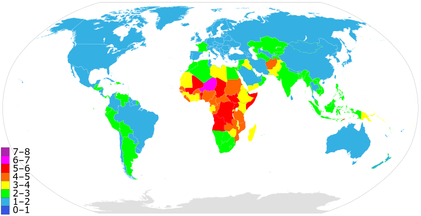
A more precise world map of country fertility rates, as listed at w:List of countries and territories by fertility rate. Note that this version is using outdated data; newer figures (e.g. 2015) are available
See also: Image:Fertility rate world map.PNG from 2006.
බලපත්රීකරණය
| මම, මෙම කාර්යයේ ප්රතිරූපණ අයිති හිමිකරු, මෙම කාර්යය public domain වෙත නිදහස් කරමි. මෙය ලෝක ව්යාප්තව අදාළ වේ. සමහර රටවල මෙය අනීතික විය හැකිය. එසේ වුවහොත්; මම කිසිදු කොන්දේසියකින් තොරව,ඕනෑම අයෙකුට ඕනෑම කාර්යයක් සඳහා මෙය, නීතිමය බාධාවක් නොමැති වනතුරු, භාවිතා කිරීමේ අයිතිය ලබාදෙමි. |
ගොනු ඉතිහාසය
එම අවස්ථාවෙහිදී ගොනුව පැවැති ආකාරය නැරඹීමට දිනය/වේලාව මත ක්ලික් කරන්න.
| දිනය/වේලාව | කුඩා-රූපය | මාන | පරිශීලක | පරිකථනය | |
|---|---|---|---|---|---|
| වත්මන් | 21:49, 23 අප්රේල් 2022 | | 864 × 443 (113 කි.බ.) | Innab | Updated with new 2020 data from CIA Factbook: https://www.cia.gov/the-world-factbook/field/total-fertility-rate/country-comparison#:~:text=Total%20fertility%20rate%20(TFR)%20compares,fertility%20rate%20at%20each%20age. |
| 06:05, 12 පෙබරවාරි 2020 |  | 864 × 443 (113 කි.බ.) | Innab | Updated with new 2020 data from CIA Factbook: https://www.cia.gov/library/publications/the-world-factbook/fields/356rank.html | |
| 19:59, 2 දෙසැම්බර් 2018 |  | 856 × 435 (117 කි.බ.) | Innab | Updated old 2006 version with new 2018 version | |
| 03:31, 17 ජූනි 2006 |  | 1,357 × 628 (40 කි.බ.) | PlatypeanArchcow | A more precise world map of country fertility rates, as listed at w:List of countries and territories by fertility rate. |
ගොනු භාවිතය
පහත දැක්වෙන පිටුව විසින් මෙම ගොනුව භාවිතා කෙරෙයි:
ගෝලීය ගොනු භාවිතය
පහත දැක්වෙන අනෙකුත් විකියන් මගින් මෙම ගොනුව භාවිතා කරයි:
- ar.wikipedia.org හි භාවිතය
- ast.wikipedia.org හි භාවිතය
- azb.wikipedia.org හි භාවිතය
- ba.wikipedia.org හි භාවිතය
- bg.wikipedia.org හි භාවිතය
- bn.wikipedia.org හි භාවිතය
- ca.wikipedia.org හි භාවිතය
- cs.wikipedia.org හි භාවිතය
- de.wikipedia.org හි භාවිතය
- en.wikipedia.org හි භාවිතය
- eo.wikipedia.org හි භාවිතය
- es.wikipedia.org හි භාවිතය
- et.wikipedia.org හි භාවිතය
- eu.wikipedia.org හි භාවිතය
- fa.wikipedia.org හි භාවිතය
- fi.wikipedia.org හි භාවිතය
- fr.wikipedia.org හි භාවිතය
- he.wikipedia.org හි භාවිතය
- hy.wikipedia.org හි භාවිතය
- id.wikipedia.org හි භාවිතය
- it.wikipedia.org හි භාවිතය
- kk.wikipedia.org හි භාවිතය
- ko.wikipedia.org හි භාවිතය
- nl.wikipedia.org හි භාවිතය
- or.wikipedia.org හි භාවිතය
- pt.wikipedia.org හි භාවිතය
- ru.wikipedia.org හි භාවිතය
- Население Земли
- Африка
- Демографический кризис в Российской Федерации
- Рождаемость
- Демографический переход
- Суммарный коэффициент рождаемости
- Демографические проблемы
- Демографическое старение
- Депопуляция
- Чёрная Африка
- Перенаселение
- Мальтузианская ловушка
- Контроль рождаемости
- Список стран по суммарному коэффициенту рождаемости
- Википедия:Синдром детства
- Демографический дивиденд
- Участник:Resen1x/Черновик2
මෙම ගොනුවේ තවත් ගෝලීය භාවිත බලන්න.
Text is available under the CC BY-SA 4.0 license; additional terms may apply.
Images, videos and audio are available under their respective licenses.
Cover photo is available under {{::mainImage.info.license.name || 'Unknown'}} license.
Cover photo is available under {{::mainImage.info.license.name || 'Unknown'}} license.
Credit:
(see original file).
