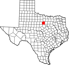
Hrabstwo Palo Pinto
| hrabstwo | |
 Widok na rzekę Brazos w hrabstwie Palo Pinto | |
| Państwo | |
|---|---|
| Stan | |
| Siedziba | |
| Powierzchnia |
2552 km² |
| Populacja (2023) • liczba ludności |
|
| • gęstość |
12 os./km² |
Położenie na mapie Teksas
| |
| Strona internetowa | |

Hrabstwo Palo Pinto – hrabstwo położone w USA, w stanie Teksas, w sąsiedztwie metropolii Dallas–Fort Worth. Utworzone w 1856 r. Według danych z 2023 roku liczy 29,7 tys. mieszkańców[1]. Siedzibą hrabstwa jest Palo Pinto, a największym miastem Mineral Wells.
Gospodarka
[edytuj | edytuj kod]Średni dochód gospodarstwa domowego (dane z 2022) w hrabstwie wynosi 65 242 dolarów, zaś dochód na mieszkańca 31 890 dolarów. 15,7% mieszkańców żyje poniżej relatywnej granicy ubóstwa[1]. Do głównych zajęć w hrabstwie należą[2][3]:
- turystyka[4]
- akwakultura (19. miejsce w stanie)
- hodowla koni, bydła, kóz, owiec i drobiu
- uprawa drzewek świątecznych, warzyw, orzechów pekan i brzoskwiń[5]
- szkółkarstwo
- produkcja siana
- wydobycie gazu ziemnego i ropy naftowej[6].
Sąsiednie hrabstwa
[edytuj | edytuj kod]- Hrabstwo Jack (północ)
- Hrabstwo Parker (wschód)
- Hrabstwo Hood (południowy wschód)
- Hrabstwo Erath (południe)
- Hrabstwo Eastland (południowy zachód)
- Hrabstwo Stephens (zachód)
- Hrabstwo Young (północny zachód)
Miasta
[edytuj | edytuj kod]CDP
[edytuj | edytuj kod]Demografia
[edytuj | edytuj kod]Według danych pięcioletnich z 2022 roku, 84,7% mieszkańców stanowili biali (73,1% nie licząc Latynosów), 20,5% to Latynosi, 2,6% czarni lub Afroamerykanie, 7,1% było rasy mieszanej, 1% deklarował pochodzenie azjatyckie i 0,8% to rdzenna ludność Ameryki[7].
Religia
[edytuj | edytuj kod]
Członkostwo w 2020 roku[8]:
- protestanci – ponad 45% (w tym baptyści – 30,8%, zielonoświątkowcy, campbellici i inni ewangelikalni – ok. 10%, metodyści – 4% i inni)
- katolicy – 8,3%
- mormoni – 1,2%
- świadkowie Jehowy – 0,87%
- bahaiści – 0,17%.
Przypisy
[edytuj | edytuj kod]- ↑ a b U.S. Census Bureau QuickFacts: Palo Pinto, Texas [online], www.census.gov [dostęp 2022-02-06] (ang.).
- ↑ Census of Agriculture - 2022 Census Publications - State and County Profiles - Texas [online], www.nass.usda.gov [dostęp 2024-07-06].
- ↑ Census of Agriculture - 2017 Census Publications - State and County Profiles - Texas [online], www.nass.usda.gov [dostęp 2024-07-06].
- ↑ TSHA | Palo Pinto County [online], www.tshaonline.org [dostęp 2023-05-04].
- ↑ Trammell talks Texas agriculture [online], Rotary Club of Mineral Wells [dostęp 2023-05-04] (ang.).
- ↑ TexasCounties.net Statistics Home Page [online], www.texascounties.net [dostęp 2023-05-04].
- ↑ Explore Census Data [online], data.census.gov [dostęp 2024-07-06].
- ↑ Congregational Membership [online], www.thearda.com [dostęp 2023-05-04].
Linki zewnętrzne
[edytuj | edytuj kod]Text is available under the CC BY-SA 4.0 license; additional terms may apply.
Images, videos and audio are available under their respective licenses.

