ਲਖਮੀਰ ਵਾਲਾ
ਲਖਮੀਰ ਵਾਲਾ | |
|---|---|
ਪਿੰਡ | |
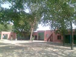
 ਸਥਾਨਕ ਪ੍ਰਾਇਮਰੀ ਸਕੂਲ ਦਾ ਦ੍ਰਿਸ਼ | |
| ਗੁਣਕ: 29°51′36″N 75°23′35″E / 29.860°N 75.393°E | |
| ਦੇਸ਼ | |
| ਰਾਜ | ਪੰਜਾਬ |
| ਜ਼ਿਲ੍ਹਾ | ਮਾਨਸਾ ਜ਼ਿਲ੍ਹਾ, ਭਾਰਤ |
| ਭਾਸ਼ਾਵਾਂ | |
| • ਸਰਕਾਰੀ | ਪੰਜਾਬੀ |
| ਸਮਾਂ ਖੇਤਰ | ਯੂਟੀਸੀ+5:30 (ਭਾਰਤੀ ਮਿਆਰੀ ਸਮਾਂ) |
| ਪਿੰਨ ਕੋਡ | 151505 |
| ਟੈਲੀਫੋਨ ਕੋਡ | 01659 |
| ਨਜ਼ਦੀਕੀ ਸ਼ਹਿਰ | ਝੁਨੀਰ |
ਲਖਮੀਰ ਵਾਲਾ ਪੰਜਾਬ ਦੇ ਮਾਨਸਾ ਜ਼ਿਲ੍ਹੇ ਦੀ ਤਹਿਸੀਲ ਬੁਢਲਾਡਾ ਦਾ ਇੱਕ ਪਿੰਡ ਹੈ।[1] 2001 ਵਿੱਚ ਲਖਮੀਰ ਵਾਲਾ ਦੀ ਅਬਾਦੀ 1584 ਸੀ। ਇਸ ਦਾ ਖੇਤਰਫ਼ਲ 6.32 ਕਿ. ਮੀ. ਵਰਗ ਹੈ।
ਭੂਗੋਲ
[ਸੋਧੋ]ਇਹ ਲਗਭਗ 'ਤੇ ਕੇਂਦਰਿਤ ਹੈ29°51′36″N 75°23′35″E / 29.86000°N 75.39306°E,[2] ਸਿਰਫ 19 'ਤੇ ਸਥਿਤ ਹੈ ਮਾਨਸਾ ਤੋਂ ਕਿਲੋਮੀਟਰ ਅਤੇ 10 ਝੁਨੀਰ ਤੋਂ ਕਿ.ਮੀ. ਚਚੋਹਰ, ਕੋਟ ਧਰਮੂ, ਭੰਮੇ ਖੁਰਦ, ਅੱਕਾਂ ਵਾਲੀ[3] ਅਤੇ ਖਿਆਲੀ ਚੇਹਲਾਂ ਵਾਲੀ ਨੇੜਲੇ ਪਿੰਡ ਹਨ।
ਇਤਿਹਾਸ
[ਸੋਧੋ]ਲਖਮੀਰਵਾਲਾ ਹੜੱਪਾ ਸੱਭਿਅਤਾ ਨਾਲ ਸਬੰਧਤ ਪੁਰਾਤੱਤਵ ਅਵਸ਼ੇਸ਼ਾਂ ਦਾ ਸਥਾਨ ਹੈ।[4] [1][5] ਭਾਰਤੀ ਪੁਰਾਤੱਤਵ ਸਰਵੇਖਣ ਨੇ ਨੇੜਲੇ ਧਲੇਵਾਂ ਵਿਖੇ ਵੀ ਖੁਦਾਈ ਕਰਵਾਈ ਹੈ ਜਿਸ ਵਿੱਚ ਹੜੱਪਾ ਸਭਿਅਤਾ ਦੀਆਂ ਲੱਭਤਾਂ ਸਾਹਮਣੇ ਆਈਆਂ ਹਨ।[6]
ਸੱਭਿਆਚਾਰ
[ਸੋਧੋ]ਪੰਜਾਬੀ ਮਾਂ ਬੋਲੀ ਦੇ ਨਾਲ-ਨਾਲ ਇੱਥੋਂ ਦੀ ਸਰਕਾਰੀ ਭਾਸ਼ਾ ਵੀ ਹੈ। ਪਿੰਡ ਦੇ ਜੱਟ ਗੋਤ ਵਿੱਚ ਜਾਗਲ, ਚਾਹਲ, ਬਰਾੜ ਸਿੱਧੂ ਭੱਠਲ ਅਤੇ ਸੰਧੂ ਭੱਟੀ ਸ਼ਾਮਲ ਹਨ ।
ਧਰਮ
[ਸੋਧੋ]ਧਰਮ ਦੁਆਰਾ, ਪਿੰਡ ਵਿੱਚ ਸਿੱਖਾਂ ਦਾ ਦਬਦਬਾ ਹੈ, ਹਿੰਦੂ ਅਤੇ ਮੁਸਲਿਮ ਘੱਟ ਗਿਣਤੀਆਂ ਦੇ ਨਾਲ ਸਿੱਖ ਧਰਮ ਦੇ ਪੈਰੋਕਾਰ ਹਨ।
ਜਨਸੰਖਿਆ
[ਸੋਧੋ]2001 ਦੀ ਮਰਦਮਸ਼ੁਮਾਰੀ ਦੇ ਅਨੁਸਾਰ, ਪਿੰਡ ਦੀ ਕੁੱਲ ਆਬਾਦੀ 1,584 ਹੈ ਜਿਸ ਵਿੱਚ 280 ਪਰਿਵਾਰਾਂ, 861 ਮਰਦ ਅਤੇ 723 ਔਰਤਾਂ ਹਨ।[7]
ਸਿੱਖਿਆ
[ਸੋਧੋ]ਚਚੋਹਰ ਦੇ ਰਸਤੇ ਵਿੱਚ ਇੱਕ ਸਰਕਾਰੀ ਪ੍ਰਾਇਮਰੀ ਸਕੂਲ[8] ਹੈ।

ਹੋਰ ਦੇਖੋ
[ਸੋਧੋ]ਹਵਾਲੇ
[ਸੋਧੋ]- ↑ "Blockwise List of Villages". ਪੰਜਾਬ ਰਾਜ ਪਲਾਨਿੰਗ ਬੋਰਡ. Retrieved 11 ਅਪਰੈਲ 2013.
- ↑ Google Maps
- ↑ "Compensate affected farmers, demands BKU". The Tribune. 17 August 2008. Retrieved 20 June 2012.
- ↑ Singh., Upinder (2016). History of Ancient India (Hindi). Pearson India. p. 147. ISBN 978-93-325-8472-3. OCLC 993687317.
- ↑ Not to be confused with the Lakhmir Mound in Sind, Pakistan.
- ↑ Verfasser., Madhu Bala 1954-. Excavations at Dhalewan (1999-2000 et 2001-2002). OCLC 1101920366.
((cite book)):|last=has generic name (help)CS1 maint: numeric names: authors list (link) - ↑ www.censusindia.gov.in
- ↑ Both pictures above, taken by Tari Buttar, is the proof itself
29°51′38″N 75°23′36″E / 29.860694°N 75.393277°E((#coordinates:)): cannot have more than one primary tag per page
Text is available under the CC BY-SA 4.0 license; additional terms may apply.
Images, videos and audio are available under their respective licenses.


