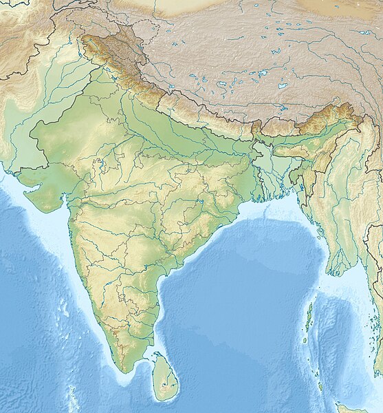
ਤਸਵੀਰ:India relief location map.jpg

ਅਸਲ ਫ਼ਾਈਲ (1,500 × 1,615 ਪਿਕਸਲ, ਫ਼ਾਈਲ ਅਕਾਰ: 1.91 MB, MIME ਕਿਸਮ: image/jpeg)
ਫ਼ਾਈਲ ਦਾ ਅਤੀਤ
ਤਾਰੀਖ/ਸਮੇਂ ’ਤੇ ਕਲਿੱਕ ਕਰੋ ਤਾਂ ਉਸ ਸਮੇਂ ਦੀ ਫਾਈਲ ਪੇਸ਼ ਹੋ ਜਾਵੇਗੀ।
| ਮਿਤੀ/ਸਮਾਂ | ਨਮੂਨਾ | ਨਾਪ | ਵਰਤੋਂਕਾਰ | ਟਿੱਪਣੀ | |
|---|---|---|---|---|---|
| ਮੌਜੂਦਾ | 13:56, 14 ਅਕਤੂਬਰ 2020 |  | 1,500 × 1,615 (1.91 MB) | NordNordWest | upd Telangana/Andhra Pradesh |
| 15:48, 17 ਜੁਲਾਈ 2020 |  | 1,500 × 1,615 (1.91 MB) | NordNordWest | + Ladakh | |
| 15:51, 31 ਜੁਲਾਈ 2016 |  | 1,500 × 1,615 (1.93 MB) | Julieta39 | According with User:NordNordWest: Thick grey line = de facto & de jure recognised borders; slim grey line = de facto contested borders; broken grey line = claimed borders. | |
| 12:30, 31 ਜੁਲਾਈ 2016 |  | 1,500 × 1,615 (1.9 MB) | NordNordWest | Reverted to version as of 20:09, 5 June 2014 (UTC); no text in location maps, has to work in all languages | |
| 16:50, 30 ਜੁਲਾਈ 2016 |  | 1,500 × 1,615 (1.94 MB) | Julieta39 | More clarely : Thick grey line = de facto & de jure recognised borders ; Slim grey line = de facto contested borders ; Broken grey line = claimed borders (cbI = by India, cbP = by Pakistan, cbC = by China). | |
| 20:09, 5 ਜੂਨ 2014 |  | 1,500 × 1,615 (1.9 MB) | NordNordWest | + Telangana | |
| 14:21, 7 ਜੂਨ 2011 |  | 1,500 × 1,615 (1.95 MB) | NordNordWest | + missing Nagaland | |
| 15:31, 23 ਅਪਰੈਲ 2010 |  | 1,500 × 1,615 (2 MB) | Uwe Dedering | ((Information |Description=((en|1=Location map of India. Equirectangular projection. Strechted by 106.0%. Geographic limits of the map: * N: 37.5° N * S: 5.0° N * W: 67.0° E * E: 99.0° E Made with Natural Earth. Free vector and raster map data @ natur |
ਫ਼ਾਈਲ ਦੀ ਵਰਤੋਂ
ਇਹ ਫਾਈਲ ਹੇਠਾਂ ਦਿੱਤੇ 84 ਸਫ਼ੇ ਵਰਤਦੇ ਹਨ:
- 2022 ਮੋਰਬੀ ਪੁਲ ਹਾਦਸਾ
- ਅਮੀਨਪੁਰ ਝੀਲ
- ਅਰੇਕੇਰੇ ਝੀਲ
- ਉਮਦਾ ਸਾਗਰ ਝੀਲ
- ਉਰਪਦ ਬੀਲ
- ਉਸਮਾਨ ਸਾਗਰ
- ਏਨਾਮੱਕਲ ਝੀਲ
- ਓਖਲਾ ਬੈਰਾਜ
- ਓਸਟੇਰੀ ਝੀਲ
- ਕਰਾਲਡ ਝੀਲ
- ਕਰੇਰੀ ਝੀਲ
- ਕਵਾਯੀ ਬੈਕਵਾਟਰਸ
- ਕਾਂਜੀਆ ਝੀਲ
- ਕਾਕੀ ਸਰੋਵਰ
- ਕਿਉਲਾਦਿਉ ਕੌਮੀ ਪਾਰਕ
- ਕੁੰਦਵਡਾ ਕੇਰੇ
- ਕੰਜੀਰਾਪੁਝਾ ਡੈਮ
- ਕੱਦਮ ਪ੍ਰੋਜੈਕਟ
- ਖਾਜਾਗੁਡਾ ਝੀਲ
- ਗਡਾਸੁਰੂ ਝੀਲ
- ਗੁਰੂਡੋਂਗਮਾਰ ਝੀਲ
- ਚੰਦਰ ਨੌਨ ਜਾਂ ਚੰਦਰ ਨਾਹਨ ਝੀਲ
- ਜੀਦੀਪੱਲੀ ਸਰੋਵਰ
- ਡਲ ਝੀਲ
- ਤਿਲਆਰ ਝੀਲ
- ਦੇਹਨਾਸਰ ਝੀਲ
- ਦੇਹਰਾਦੂਨ
- ਨਾਗਾਰਜੁਨ ਸਾਗਰ ਡੈਮ
- ਨੇਯਾਰ ਡੈਮ
- ਨੰਦਾ ਗੋਂਡ
- ਨੱਲਾਗੰਡਲਾ ਝੀਲ
- ਪਟਨਾ ਅਜਾਇਬ ਘਰ
- ਪਥਰਾਲਾ ਬੈਰਾਜ
- ਪਰਮਬੀਕੁਲਮ ਡੈਮ
- ਪਰਾਸ਼ਰ ਝੀਲ
- ਪਲਾਇਰ ਝੀਲ
- ਪਾਖਲ ਝੀਲ
- ਪੇਰਿਂਗਲਕੁਥੂ ਡੈਮ
- ਪੋਚਾਰਮ ਝੀਲ
- ਪੰਡੋਹ ਡੈਮ
- ਫਤਿਹਪੁਰੀ ਮਸਜਿਦ
- ਫੁੱਲਾਂ ਦੀ ਘਾਟੀ ਨੈਸ਼ਨਲ ਪਾਰਕ
- ਬਖੀਰਾ ਬਰਡ ਸੈਂਚੂਰੀ
- ਬਰਾੜੀ ਨਾਂਬਲ
- ਬੇਲੰਦੂਰ ਝੀਲ
- ਬੰਜਾਰਾ ਝੀਲ
- ਭਾਖੜਾ ਡੈਮ
- ਮਣੀ ਮਹੇਸ਼ ਕੈਲਾਸ਼ ਚੋਟੀ
- ਮਲਮਪੁਝਾ ਡੈਮ
- ਮੇਰ ਬੀਲ
- ਯਸ਼ਵੰਤ ਸਾਗਰ
- ਯੇਲੇ ਮੱਲੱਪਾ ਸ਼ੈਟੀ ਝੀਲ
- ਰਚੇਨਾਹੱਲੀ ਝੀਲ
- ਰਾਇਲਾਦੇਵੀ ਝੀਲ
- ਰਾਇਵਾੜਾ ਸਰੋਵਰ
- ਰੁਦਰਸਾਗਰ ਝੀਲ
- ਰੂਪਕੁੰਡ
- ਰੇਵਾਲਸਰ ਝੀਲ
- ਲਾਂਬੜਾ, ਹੁਸ਼ਿਆਰਪੁਰ
- ਵਿਦਿਸ਼ਾ ਮਿਊਜ਼ੀਅਮ
- ਵਿਭੂਤੀਪੁਰਾ ਝੀਲ
- ਵੇਲੀਗੱਲੂ ਡੈਮ ਸਰੋਵਰ
- ਸਤੋਪੰਥ ਤਾਲ
- ਸ਼ਨਾਲੇਸ਼ਵਰ ਸਵੈਯੰਭੂ ਮੰਦਰ
- ਸ਼ੁਕਰਵਾੜੀ ਝੀਲ
- ਸ਼੍ਰੀ ਕੋਮਾਰਾਮ ਭੀਮ ਪ੍ਰੋਜੈਕਟ
- ਸੁੰਦਰਵਨ ਨੈਸ਼ਨਲ ਪਾਰਕ
- ਸੈਂਟੇਨਲੀ ਕਬੀਲਾ
- ਸੰਨੀਹਿਤ ਸਰੋਵਰ
- ਹਲਲੀ ਸਰੋਵਰ
- ਹੀਰਾਕੁੰਡ ਡੈਮ
- ਹੇਬਲ ਝੀਲ, ਬੰਗਲੌਰ
- ਹੰਪੀ
- ਫਰਮਾ:Location map India New Delhi
- ਫਰਮਾ:Location map India airport
- ਫਰਮਾ:ਸਥਿਤੀ ਨਕਸ਼ਾ ਭਾਰਤ
- ਮੌਡਿਊਲ:Location map/data/India
- ਮੌਡਿਊਲ:Location map/data/India/doc
- ਮੌਡਿਊਲ:Location map/data/India1
- ਮੌਡਿਊਲ:Location map/data/India1/doc
- ਮੌਡਿਊਲ:Location map/data/India2
- ਮੌਡਿਊਲ:Location map/data/India2/doc
- ਮੌਡਿਊਲ:Location map/data/India3
- ਮੌਡਿਊਲ:Location map/data/India3/doc
ਫ਼ਾਈਲ ਦੀ ਵਿਆਪਕ ਵਰਤੋਂ
ਇਸ ਫ਼ਾਈਲ ਨੂੰ ਹੋਰ ਹੇਠ ਲਿਖੇ ਵਿਕੀ ਵਰਤਦੇ ਹਨ:
- ace.wikipedia.org ਉੱਤੇ ਵਰਤੋਂ
- af.wikipedia.org ਉੱਤੇ ਵਰਤੋਂ
- als.wikipedia.org ਉੱਤੇ ਵਰਤੋਂ
- am.wikipedia.org ਉੱਤੇ ਵਰਤੋਂ
- anp.wikipedia.org ਉੱਤੇ ਵਰਤੋਂ
- ar.wikipedia.org ਉੱਤੇ ਵਰਤੋਂ
- ast.wikipedia.org ਉੱਤੇ ਵਰਤੋਂ
- as.wikipedia.org ਉੱਤੇ ਵਰਤੋਂ
- azb.wikipedia.org ਉੱਤੇ ਵਰਤੋਂ
- az.wikipedia.org ਉੱਤੇ ਵਰਤੋਂ
- Kəşmir vadisi
- Şablon:Yer xəritəsi Hindistan
- Benqal körfəzi
- Andaman dənizi
- Bandipur Milli Parkı
- Lakkadiv dənizi
- Səkkizinci Dərəcə boğazı
- Doqquzuncu Dərəcə boğazı
- Onuncu Dərəcə boğazı
- Dunkan boğazı
- Polk boğazı
- Caldapara Milli Parkı
- Cafna yarımadası
- Kathiyavar yarımadası
- Hindustan
- Tar (səhra)
- Andaman adaları
- Nikobar adaları
- Mahatma Qandi Dəniz Milli Parkı
- Şrixarikota
- Bombey adası
- Sundarban
ਇਸ ਫ਼ਾਈਲ ਦੀ ਹੋਰ ਵਿਆਪਕ ਵਰਤੋਂ ਵੇਖੋ।
ਮੈਟਾਡੈਟਾ
Text is available under the CC BY-SA 4.0 license; additional terms may apply.
Images, videos and audio are available under their respective licenses.


