മക്ഡൊണെൽ റേഞ്ചസ്
| മക്ഡൊണെൽ MacDonnell | |
|---|---|
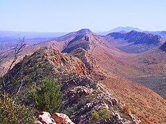
 മക്ഡൊണെൽ റേഞ്ചുകളിലെ ഗ്ലെൻ ഹെലൻ മലയിടുക്ക് | |
| ഉയരം കൂടിയ പർവതം | |
| Peak | മൗണ്ട് സീൽ |
| Elevation | 1,531 m (5,023 ft) AHD |
| Coordinates | 23°22′59″S 132°22′59″E / 23.38306°S 132.38306°E |
| വ്യാപ്തി | |
| നീളം | 644 km (400 mi) E/W |
| മറ്റ് പേരുകൾ | |
| Etymology | സർ റിച്ചാർഡ് മക്ഡൊണൽ |
| ഭൂമിശാസ്ത്രപരമായ പ്രത്യേകതകൾ | |
 നോർത്തേൺ ടെറിട്ടറിയിൽ മക്ഡൊണെൽ റേഞ്ചസിന്റെ സ്ഥാനം | |
| Country | ഓസ്ട്രേലിയ |
| ടെറിട്ടറി | നോർത്തേൺ ടെറിട്ടറി |
| റീജിയൻ | ആലീസ് സ്പ്രിങ്സ് |
| Range coordinates | 23°42′S 132°30′E / 23.700°S 132.500°E |
| ഭൂവിജ്ഞാനീയം | |
| Age of rock | കാർബോണിഫറസ് |
| MacDonnell Ranges നോർത്തേൺ ടെറിട്ടറി | |||||||||||||||
|---|---|---|---|---|---|---|---|---|---|---|---|---|---|---|---|
 The interim Australian bioregions, with the MacDonnell Ranges in red | |||||||||||||||
| വിസ്തീർണ്ണം | 39,294 km2 (15,171.5 sq mi) | ||||||||||||||
| |||||||||||||||
3,929,444 ഹെക്ടർ (9,709,870 ഏക്കർ) വിസ്തൃതിയുള്ള ഒരു പർവതനിരയും ഇടക്കാല ഓസ്ട്രേലിയൻ ബയോറിജിയനുമാണ് മക്ഡൊണെൽ റേഞ്ചസ്.[1][2] മധ്യ ഓസ്ട്രേലിയയിലെ 644 കിലോമീറ്റർ (400 മൈൽ) നീളമുള്ള പർവതനിരകളായ ഈ ശ്രേണി, ആലീസ് സ്പ്രിംഗ്സിന്റെ കിഴക്കും പടിഞ്ഞാറും ഒഴുകുന്ന സമാന്തര വരമ്പുകൾ ഉൾക്കൊള്ളുന്നു. മധ്യ ഓസ്ട്രേലിയയിലെ 644 കിലോമീറ്റർ (400 മൈൽ) നീളമുള്ള പർവതനിരകളാണ് ഈ റേഞ്ച്. ആലീസ് സ്പ്രിംഗ്സിന്റെ കിഴക്കും പടിഞ്ഞാറുമുള്ള കുന്നിൻ പ്രദേശങ്ങളും ഇതിൽ ഉൾക്കൊള്ളുന്നു. പർവതനിരയിൽ നിരവധി മനോഹരമായ വിടവുകളും മലയിടുക്കുകളും ആദിവാസി പ്രാധാന്യമുള്ള പ്രദേശങ്ങളും അടങ്ങിയിരിക്കുന്നു.
ഈ റേഞ്ചുകൾക്ക് റിച്ചാർഡ് ഗ്രേവ്സ് മക്ഡൊണെലിന്റെ പേര് (അക്കാലത്ത് സൗത്ത് ഓസ്ട്രേലിയയുടെ ഗവർണർ ആയിരുന്നു) പര്യവേഷകനായിരുന്ന ജോൺ മക്ഡൊവൽ സ്റ്റുവർട്ട് നാമകരണം ചെയ്തു. 1860-ലെ പര്യവേഷണം ആ വർഷം ഏപ്രിലിൽ എത്തി. മധ്യ ഓസ്ട്രേലിയയിലേക്കുള്ള ശാസ്ത്ര പര്യവേഷണത്തിന്റെ ഭാഗമായാണ് പ്രകൃതി ചരിത്രത്തെപ്പറ്റി അന്വേഷിച്ചത്. ഡേവിഡ് ലിൻഡ്സെ, ജോൺ റോസ് എന്നിവരും ഇിതിലെ മറ്റ് പര്യവേക്ഷകരിൽ ഉൾപ്പെടുന്നു.
മക്ഡൊണെൽ റേഞ്ചുകൾ പലപ്പോഴും ആൽബർട്ട് നമത്ജിറയുടെ ചിത്രങ്ങളിൽ ചിത്രീകരിച്ചിരുന്നു.[3]
ഭൂമിശാസ്ത്രം
[തിരുത്തുക]മൗണ്ട് സീൽ (1531 മീറ്റർ), മൗണ്ട് ലിബിഗ് (1524 മീറ്റർ), മൗണ്ട് എഡ്വേർഡ് (1423 മീറ്റർ), മൗണ്ട് ഗൈൽസ് (1389), Mount Sonder (1380 മീറ്റർ) എന്നിവയാണ് നോർത്തേൺ ടെറിട്ടറിയിലെ ഏറ്റവും ഉയരമുള്ള അഞ്ച് കൊടുമുടികൾ.[4] ടോഡ്, ഫിങ്കെ സാൻഡോവർ എന്നീ നദികൾ ഉത്ഭവിക്കുന്നത് മക്ഡൊണൽ റേഞ്ചിൽ നിന്നുമാണ്. ഓസ്ട്രേലിയൻ ഓവർലാന്റ് ടെലിഗ്രാഫ് ലൈനും സ്റ്റുവർട്ട് ഹൈവേയും റേഞ്ച് മറികടക്കുന്നു.
ഭൂഗർഭശാസ്ത്രം
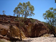
[തിരുത്തുക]300-350 ദശലക്ഷം വർഷങ്ങൾക്ക് മുമ്പ് ഒരു പർവത നിർമ്മാണത്തിലൂടെ മക്ഡൊണെൽ റേഞ്ചസ് സൃഷ്ടിച്ചു.[4] അക്കാലം മുതൽ മണ്ണൊലിപ്പും മറ്റു പ്രവർത്തനങ്ങളും മൂലം റേഞ്ചിനു രൂപം നൽകുകയും നിരവധി വിടവുകളും മലയിടുക്കുകളും സൃഷ്ടിക്കുകയും ചെയ്തു.[4][5] ഇവിടെ പല ശിലാതരങ്ങളും അടങ്ങിയിരിക്കുന്നു. ചുവന്ന ക്വാർട്ട്സൈറ്റ് കൊടുമുടികൾക്കും മലയിടുക്കുകൾക്കും ഇവിടം പ്രസിദ്ധമാണ്. ഗ്രാനൈറ്റ്, ചുണ്ണാമ്പുകല്ല്, സാൻഡ്സ്റ്റോൺ, സിൽറ്റ്സ്റ്റോൺ എന്നിവയാണ് പ്രധാന പാറകൾ.[5] ഈ റേഞ്ചുകളിലെ ചില താഴ്വരകളിൽ ഒരു കാലത്ത് മധ്യ ഓസ്ട്രേലിയയെ ഉൾക്കൊള്ളുന്ന ഉൾനാടൻ കടലിന്റെ ഫോസിൽ തെളിവുകൾ അടങ്ങിയിരിക്കുന്നു.[5]
പരിസ്ഥിതി ശാസ്ത്രം
[തിരുത്തുക]മക്ഡൊണലിന്റെ മധ്യനിരകളുടെ ഭാഗം വരണ്ട സ്ക്രബ്ബി പുൽമേടുകളുടെ കേന്ദ്രമാണ്. ഇവിടെ സെൻട്രേലിയൻ ട്രീ ഫ്രോഗ് (Ranoidea gilleni) ഉൾപ്പെടെ നിരവധി വംശനാശഭീഷണി നേരിടുന്ന ഇനങ്ങൾ കാണപ്പെടുന്നു.[6]
വിനോദസഞ്ചാര കേന്ദ്രങ്ങൾ
[തിരുത്തുക]മക്ഡൊണെലിനുള്ളിൽ താമസിക്കുന്നവരെ ഉൾപ്പെടെ നിരവധി പുൽമേടുകളും മറ്റു കരുതൽ ശേഖരങ്ങളും സംരക്ഷിക്കുന്നതിനായി 1984-ലാണ് വെസ്റ്റ് മക്ഡൊണെൽ നാഷണൽ പാർക്ക് സ്ഥാപിതമായത്.[5] ലാറപിന്ത വനപാതയുടെ വികസനത്തിനും ഇത് സഹായകമായി. ആലീസ് സ്പ്രിംഗ്സിന്റെ കിഴക്ക് പ്രാദേശിക അറേൻടെ ആദിവാസികൾക്ക് പ്രധാനപ്പെട്ട ഇടങ്ങളാണ്. അവയിൽ പലതും ആദിവാസി റോക്ക് ആർട്ടിന്റെ ഉദാഹരണങ്ങൾ നിലനിൽക്കുന്നു. ഇതിൽ എമിലി ഗ്യാപ്പ്, ജെസ്സി ഗ്യാപ്പ്, ട്രെഫിന ഗോർഗ്, എൻഡാല ഗോർഗ് എന്നിവ ഉൾപ്പെടുന്നു.
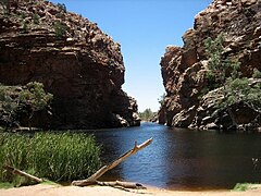
ആലീസ് സ്പ്രിംഗ്സിന്റെ പടിഞ്ഞാറ് ഭാഗത്ത് ലാരപിന്റ വനപാത ഉണ്ട്. ദീർഘദൂരമുള്ള ഈ പാത മക്ഡൊണലിന്റെ നടുവിലൂടെ 223 കിലോമീറ്റർ (139 മൈൽ) നീളുന്നു..[5] ഈ നടപ്പാതയിൽ സിംപ്സൺസ് ഗ്യാപ്പ്, സ്റ്റാൻഡ്ലി ചേസം, എല്ലെറി ക്രീക്ക് ബിഗ് ഹോൾ, സെർപന്റൈൻ ഗോർഗ്, ഓച്ചർ പിറ്റ്സ്, ഓർമിസ്റ്റൺ പൗണ്ട്, റെഡ്ബാങ്ക് ഗോർഗ്, ഗ്ലെൻ ഹെലൻ ഗോർഗ്, ഗോസ്സസ് ബ്ലഫ് ക്രാട്ടർ, പാം വാലി, മൗണ്ട് സോണ്ടർ, മൗണ്ട് സീൽ, മൗണ്ട് ഗൈൽസ് എന്നിവ ഉൾപ്പെടുന്നു.
ചിത്രശാല
[തിരുത്തുക]-
 ഗ്ലെൻ ഹെലനിൽ നിന്ന് ലാറാപിന്ത വനപാത
 -
 എല്ലെരി ക്രീക്ക് ബിഗ് ഹോൾ
 -
 എല്ലെറി ക്രീക്കും റിവർ റെഡ് ഗം മരങ്ങളും
 -
 ഓച്ചർ പിറ്റ്സ്
 -
 സിംസൺസ് ഗ്യാപ്
 -
 സെർപെന്റൈൻ ഗോർഗ്


അവലംബം
[തിരുത്തുക]- ↑ Environment Australia. "Revision of the Interim Biogeographic Regionalisation for Australia (IBRA) and Development of Version 5.1 - Summary Report". Department of the Environment and Water Resources, Australian Government. Archived from the original on 2006-09-05. Retrieved 2007-01-31.
((cite journal)): Cite journal requires|journal=(help) - ↑ IBRA Version 6.1 Archived 2006-09-08 at the Wayback Machine. data
- ↑ Joanne Lane (5 September 2009). "Drawn by a legend". theage.com.au. Fairfax Digital. Archived from the original on 2014-06-02. Retrieved 2009-11-17.
- ↑ 4.0 4.1 4.2 "Rangelands - Overview - MacDonnell Ranges". Australian Natural Resources Atlas. Department of the Environment, Water, Heritage and the Arts. Archived from the original on 2009-10-05. Retrieved 2009-11-17.
- ↑ 5.0 5.1 5.2 5.3 5.4 Hema Maps (1997). Discover Australia's National Parks. Milsons Point, New South Wales: Random House Australia. pp. 242–246. ISBN 1-875992-47-2.
- ↑ World Wildlife Fund, ed. (2001). "Central Ranges xeric scrub". WildWorld Ecoregion Profile. National Geographic Society. Archived from the original on 2010-03-08.
പുറത്തേക്കുള്ള കണ്ണികൾ
[തിരുത്തുക]Text is available under the CC BY-SA 4.0 license; additional terms may apply.
Images, videos and audio are available under their respective licenses.
