ബാഫിൻ ദ്വീപ്
| Native name: ᕿᑭᖅᑖᓗᒃ (Qikiqtaaluk) | |
|---|---|
 | |
 | |
| Geography | |
| Location | വടക്കൻ കാനഡ |
| Coordinates | 68°N 70°W / 68°N 70°W |
| Archipelago | ആർട്ടിക് ദ്വീപസമൂഹം |
| Area | 507,451 km2 (195,928 sq mi) |
| Area rank | 5th |
| Highest elevation | 2,147 m (7,044 ft) |
| Highest point | മൌണ്ട് ഓഡിൻ |
| Administration | |
കാനഡ | |
| Territory | നുനാവട് |
| Largest settlement | ഇക്വാല്യൂട്ട് (pop. 7,740) |
| Demographics | |
| Population | 13,148[1] (2016) |
| Pop. density | 0.02 /km2 (0.05 /sq mi) |
| Ethnic groups | Inuit (72.7%), non-Aboriginal (25.3%), First Nations (0.7%), Métis (0.5%)[2] |
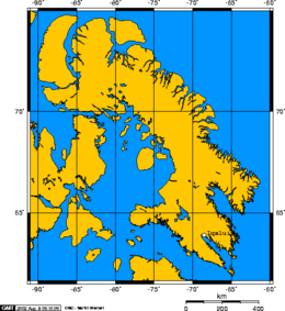
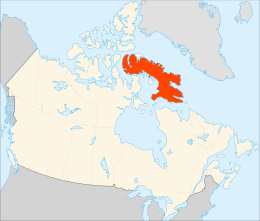
കാനഡയിലെ നൂനവുട്, കേന്ദ്രഭരണ പ്രദേശത്തിലെ ഒരു ദ്വീപാണ് ബാഫിൻ ദ്വീപ് (Baffin Island Inuktitut: ᕿᑭᖅᑖᓗᒃ, Qikiqtaaluk IPA: [qikiqtaːluk], French: Île de Baffin or Terre de Baffin). കാനഡയിലെ ഏറ്റവും വലിയ ദ്വീപായ ഇതിന് ലോകത്തിലെ ഏറ്റവും വലിയ അഞ്ചാമത്തെ ദ്വീപ് എന്ന സ്ഥാനമുണ്ട്. 2007-ലെ കണക്കുകൾ പ്രകാരം ഇവിടത്തെ ജനസംഖ്യ ഏകദേശം പതിനൊന്നായിരത്തോളമായിരുന്നു. ഇംഗ്ലീഷ് പര്യവേഷകനായിരുന്ന വില്ല്യം ബാഫിന്റെ പേരിൽനിന്നാണ് ദ്വീപിന് ഈ പേർ ലഭിച്ചത്.[3] ഈ ദ്വീപ് ഉത്തര അക്ഷാംശം 65.4215 പശ്ചിമ രേഖാംശം 70.9654 എന്നിവയിൽ സ്ഥിതിചെയ്യുന്നു. ഗ്രീൻലാന്റ്, ഐസ്ലാന്റ് എന്നിവിടങ്ങളിൽനിന്നുമുള്ള പര്യവേഷകർക്ക് 'ബാഫിൻ ദ്വീപ് പരിചയമുണ്ടായിരുന്നതായി കരുതപ്പെടുന്നു, ഐസ്ലാന്റിക് വീരകഥകളിൽ പരാമർശിക്കപ്പെടുന്ന ഹെല്ലുലാന്റ് ഈ പ്രദേശത്താണെന്നും കരുതപ്പെടുന്നു.
ഭൂമിശാസ്ത്രം
[തിരുത്തുക]


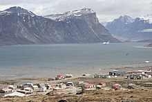
നൂനവുടിന്റെ തലസ്ഥാനമായ ഇക്വാലുയിറ്റ്, ബാഫിൻ ദ്വീപിന്റെ തെക്ക്-കിഴക്കൻ തീരത്തായി സ്ഥിതിചെയ്യുന്നു. 1987 വരെ ഈ പട്ടണത്തിന്റെ പേർ അതു സ്ഥിതിചെയ്യുന്ന ഉൾക്കടലായിരുന്ന ഫ്രോബിഷർ ബേ എന്നായിരുന്നു[4]. ബാഫിൻ ദ്വീപിനെ വൻകരയിലെ കുബെക്കുമായി വേർതിരിക്കുന്ന ഹഡ്സൺ ഉൾക്കടൽ ദ്വീപിന്റെ തെക്ക് ഭാഗത്തായി സ്ഥിതിചെയ്യുന്നു.[5] ദ്വീപിന്റെ പടിഞ്ഞാറൻ അറ്റത്തിന്റെ തെക്കായി ഫ്യൂറി ആൻറ് ഹെക്ല കടലിടുക്ക് സ്ഥിതിചെയ്യുന്നു[6] ബാഫിൻ ദ്വീപിനും മെൽവിൽ ഉപദ്വീപിനുമിടയിലായാണ് ഈ കടലിടുക്ക് സ്ഥിതിചെയ്യുന്നത്[7]. ദ്വീപിന്റെ കിഴക്കായി സ്ഥിതിചെയ്യുന്ന ഡേവിസ് കടലിടുക്കിനും[8] ബാഫിൻ ഉൾക്കടലിനും,[9] കിഴക്കായാണ് ഗ്രീൻലാന്റ് നിലകൊള്ളുന്നത്.[5] ഫോക്സി ബേസിൻ,[10] ഗൾഫ് ഓഫ് ബൂത്തിയ[11] ലാൻകാസ്റ്റർ സൗണ്ട്[12] എന്നിവ ബാഫിൻ ദ്വീപിന്റെ വടക്കും പടിഞ്ഞാറുമായി കനേഡിയൻ ആർട്ടിക് ദ്വീപസമൂഹത്തിനും ഈ ദ്വീപിനുമിടയിലായി സ്ഥിതിചെയ്യുന്നു.
ബാഫിൻ ദ്വീപിന്റെ വടക്ക് കിഴക്കൻ തീരത്തായി ബാഫിൻ മലകൾ നിലകൊള്ളുന്നു. ഇതിലെ ഏറ്റവും ഉയരമുള്ള കൊടുമുടി ഏകദേശം 2,147 m (7,044 ft) ഉയരമുള്ള മൗണ്ട് ഓഡിൻ ആണ്[13][14]. 1,675 m (5,495 ft) ഉയരമുള്ള മൗണ്ട് തോർ ഭൂമിയിലെ ഏറ്റവും ചെങ്കുത്തായ(1,250 m (4,100 ft)) കൊടുമുടിയാണെന്ന് കരുതപ്പെടുന്നു.[15] ബാഫിൻ ദ്വീപിലെ ഏറ്റവും വലിയ തടാകങ്ങൾ നിറ്റിലിങ് തടാകം (5,542 km2 (2,140 sq mi)) അമാജക് തടാകം (3,115 km2 (1,203 sq mi)) എന്നിവയാണ്.[16][17][18]
ചരിത്രം
[തിരുത്തുക]നൂറ്റണ്ടുകളോളമായി തുടർച്ചയായി ജനവാസമുള്ള പ്രദേശമാണിത്, ഇവിടെ ഇനുയിറ്റ് വംശജരാണ് താമസിച്ചു വരുന്നത്.
ജീവജാലങ്ങൾ
[തിരുത്തുക]
ഉഷ്ണകാലത്ത് മാത്രം ഇവിടെ താമസിക്കുന്ന ജീവികളും വർഷം മുഴുവൻ താമസിക്കുന്ന ജീവികളും ഇവിടെയുണ്ട്. ഇവിടെ വർഷം മുഴുവൻ താമസിക്കുന്ന ജീവികളിൽ കരിബോ, ധ്രുവക്കരടി, ധ്രുവക്കുറുക്കൻ, ധ്രുവമുയൽ, ലെമ്മിങ് എന്നിയ ഉൾപ്പെടുന്നു.
അവലംബം
[തിരുത്തുക]- ↑ Does not include Kinngait (1,441) and Qikiqtarjuaq (598). Both of which do not lie on Baffin Island proper
- ↑ 2006 Aboriginal Population Profile for Nunavut communities.
- ↑ Quinn, Joyce A.; Woodward, Susan L. (31 January 2015). Earth's Landscape: An Encyclopedia of the World's Geographic Features. ABC-CLIO. p. 82. ISBN 978-1-61069-446-9.
- ↑ About Iqaluit: History Archived 2014-12-11 at the Wayback Machine.
- ↑ 5.0 5.1 Hudson Strait
- ↑ "Fury and Hecla Strait". Archived from the original on 2012-10-02. Retrieved 2012-10-13.
- ↑ Melville Peninsula
- ↑ Davis Strait
- ↑ Baffin Bay Archived 2012-10-06 at the Wayback Machine. with Greenland to the east
- ↑ Foxe Basin
- ↑ Gulf of Boothia
- ↑ Lancaster Sound
- ↑ "Mount Odin, Nunavut". Peakbagger.com.
- ↑ "Mount Odin at the Atlas of Canada". Archived from the original on 2012-06-25. Retrieved 2018-10-19.
- ↑ Mount Thor -The Greatest Vertical Drop on Earth!
- ↑ "Nunavut – Lake Areas and Elevation (lakes larger than 400 square kilometres)". Archived from the original on 2012-04-15. Retrieved 2018-10-19.
- ↑ Nettilling Lake location
- ↑ Amadjuak Lake location
Text is available under the CC BY-SA 4.0 license; additional terms may apply.
Images, videos and audio are available under their respective licenses.


