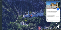
Google Earth
 Google Earth 9 izskats, izmantojot Google Chrome. | |
| Izstrādātājs | |
| Sākotnējā versija | 2001. gada 11. jūnijā |
| Izstrādes statuss | aktīvs |
| Progr. valoda | C++ |
| Operētājsistēma |
Windows, macOS, Linux Xbox One, Android 4.1+, iOS 11+ |
| Izmērs |
|
| Valoda | dažādas |
| Veids | Virtuālais globuss |
| Licence | bezmaksas |
| Tīmekļa vietne |
earth |
Google Earth ir Google uzturēta bezmaksas virtuālā globusa programma, kas, izmantojot satelītuzņēmumus, aerolāzerskenēšanu, aerofoto un ĢIS datus, renderē 3D Zemi, ļaujot lietotājiem apskatīt pilsētas un ainavas no dažādiem leņķiem. Programma ir pieejama datoros, viedtālruņos un planšetdatoros. 2019. gadā Google Earth satelītuzņēmumu pārklājums bija 97 procenti Zemes virsmas.
Google Earth režīmi
Zeme
Debesis
Google SKY funkciju ieviesa Google Earth 4.2 versijā, 2007. gada 22. augustā, un ļauj lietotājiem apskatīt zvaigznes un citus debess ķermeņus.
Marss
Google Earth 5.0 versijā ietver Google Marss funkciju. Marsa režīmā var arī apskatīt Marsa krāterus.
Okeāns
Ieviests Google Earth 5.0 versijā, 2009. gada februārī. Google Ocean ļauj lietotājiem izpētīt okeānu 3D formātā. Google Ocean slāņi satur 20 slāņus.
Attēlojums
3D virtuālās realitātes modeļi

Pirmos 3D celtņu modeļus iekš Google Earth radīja lietotāji, izmantojot 3D modelēšanas programmas kā SketchUp un Google Building Maker un augšupielādējot tās iekš Google Earth ar 3D Warehouse starpniecību.
Daļu Zemes virsmas Google Earth renderē, izmantojot aerolāzerskenēšanas ceļā iegūtu, automātiski ģenerētu fotoreālistisku 3D virtuālās realitātes modeli, tādējādi aizstājot lietotāju ģenerētās celtnes. Šo sistēmu Google ieviesa pakāpeniski, sākot ar 2012. gadu, kad šādi attēloja 21 pilsētu 4 valstīs. Līdz 2016. gadam 3D virtuālās realitātes modeļi bija ģenerēti vairākiem simtiem pilsētu vairāk kā 40 valstīs, ieskaitot visas ASV pavalstis un visus kontinentus, izņemot Antarktīdu.
Kopš 2024. gada, izmantojot 3D virtuālās realitātes modeļus, Google Earth atspoguļo vairāk nekā 1 400 km2 Latvijas teritorijas, tostarp, Jelgavu un Tukumu, kā arī daļu Dobeles, Jelgavas, Olaines, Saldus un Tukuma novada teritorijas.
| ||||||||||||||||||||||||||||||||||||||||
|
Text is available under the CC BY-SA 4.0 license; additional terms may apply.
Images, videos and audio are available under their respective licenses.
