高城山 (徳島県)
| 高城山 | |
|---|---|
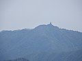
 焼山寺山山頂から望む高城山 | |
| 標高 | 1,627.9 m |
| 所在地 | 徳島県那賀郡那賀町・美馬市 |
| 位置 | 北緯33度53分30秒 東経134度14分25秒 / 北緯33.89167度 東経134.24028度座標: 北緯33度53分30秒 東経134度14分25秒 / 北緯33.89167度 東経134.24028度 |
| 山系 | 四国山地 剣山系 |
 高城山 (徳島県) (徳島県)
| |

高城山(たかしろやま)は、徳島県那賀郡那賀町と美馬市との境に位置する山である。標高1,627.9 m。四国百名山選定。
概要
[編集]剣山から発し、一ノ森を経て旧美馬郡木屋平村と旧那賀郡木沢村との境界をなしつつ東北東に延びる稜線上にある山。剣山の東北東約 15 km の地点にある。雲早山、高丸山と共に勝浦三山と呼ばれている。
名前の由来は、積雪により他の山々より際立って見える為に高白山と名付けられ、同音の漢字に書き換えられた山である。登山道は剣山スーパー林道を利用する。頂上からは南に海部郡の山々、西に剣山、北に高越山、東に雲早山などが望める。
-
 剣山より
剣山より -
 頂上
頂上


参考文献
[編集]- 『角川日本地名大辞典 36 徳島県』(1986年 ISBN 4040013603)
Text is available under the CC BY-SA 4.0 license; additional terms may apply.
Images, videos and audio are available under their respective licenses.
Cover photo is available under {{::mainImage.info.license.name || 'Unknown'}} license.
Cover photo is available under {{::mainImage.info.license.name || 'Unknown'}} license.
Credit:
(see original file).
