For faster navigation, this Iframe is preloading the Wikiwand page for 出羽山地.

出羽山地

出羽山地
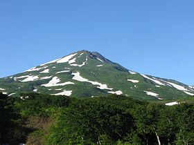
鳥海山(2014年7月撮影)
所在地 日本の旗 日本 青森県秋田県山形県
位置
出羽山地の位置(日本内)
出羽山地
北緯39度5分57秒 東経140度2分56秒 / 北緯39.09917度 東経140.04889度 / 39.09917; 140.04889座標: 北緯39度5分57秒 東経140度2分56秒 / 北緯39.09917度 東経140.04889度 / 39.09917; 140.04889
最高峰 鳥海山(2,236 m
延長 250 km
プロジェクト 山
テンプレートを表示

出羽山地(でわさんち)または出羽丘陵とは日本東北地方にある山地奥羽山脈に並び、その西側にある山地であり、青森県西部から秋田県中央部・山形県中央部を通っている。奥羽山脈との間には、横手盆地新庄盆地などが形作られている。山地の延長は約250km、最高峰鳥海山の2,236m。日本海側に面した山地であるため、季節風の影響により、冬季の積雪量は多く、植生としてはブナ林が目立つ。

東北地方の脊梁である奥羽山脈より緩やかであり、山地を横断する米代川雄物川最上川によって複数の丘陵に分割される。北より白神山地、太平山地、丁岳山地などとなっている。鳥海火山帯が分布しており、田代岳鳥海山月山などの火山も見られるが、太平山地は非火山性であるなどの違いもある。

参考文献

{{bottomLinkPreText}} {{bottomLinkText}}
出羽山地
Listen to this article

This browser is not supported by Wikiwand :(
Wikiwand requires a browser with modern capabilities in order to provide you with the best reading experience.
Please download and use one of the following browsers:

This article was just edited, click to reload
This article has been deleted on Wikipedia (Why?)

Back to homepage

Please click Add in the dialog above
Please click Allow in the top-left corner,
then click Install Now in the dialog
Please click Open in the download dialog,
then click Install
Please click the "Downloads" icon in the Safari toolbar, open the first download in the list,
then click Install
{{::$root.activation.text}}

Install Wikiwand

Install on Chrome Install on Firefox
Don't forget to rate us

Tell your friends about Wikiwand!

Gmail Facebook Twitter Link

Enjoying Wikiwand?

Tell your friends and spread the love:
Share on Gmail Share on Facebook Share on Twitter Share on Buffer

Our magic isn't perfect

You can help our automatic cover photo selection by reporting an unsuitable photo.

This photo is visually disturbing This photo is not a good choice

Thank you for helping!


Your input will affect cover photo selection, along with input from other users.

X

Get ready for Wikiwand 2.0 🎉! the new version arrives on September 1st! Don't want to wait?