ファイル:Malawi location map Topographic.png
このプレビューのサイズ: 293 × 599 ピクセル。 その他の解像度: 117 × 240 ピクセル | 235 × 480 ピクセル | 749 × 1,531 ピクセル。
元のファイル (749 × 1,531 ピクセル、ファイルサイズ: 2.07メガバイト、MIME タイプ: image/png)
ウィキメディア・コモンズのファイルページにある説明を、以下に表示します。
|
概要
| 解説 |
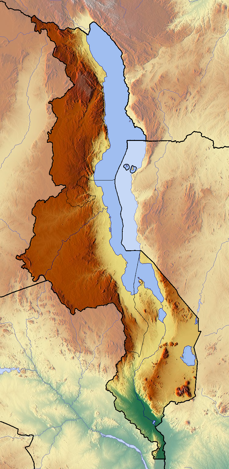
Deutsch: Positionskarte von Malawi
Quadratische Plattkarte. Geographische Begrenzung der Karte:
English: Location map of Malawi
Equirectangular projection. Geographic limits of the map:
|
| 日付 | |
| 原典 | 投稿者自身による著作物 (backgroung : http://www.maps-for-free.com) |
| 作者 | Dr Brains |
ライセンス
この作品の著作権者である私は、この作品を以下のライセンスで提供します。

|
この文書は、フリーソフトウェア財団発行のGNUフリー文書利用許諾書 (GNU Free Documentation License) バージョン1.2のみの規約に基づき、複製や再配布、改変が許可されます。不可変更部分、表紙、背表紙はありません。このライセンスの複製は、GNUフリー文書利用許諾書という章に含まれています。 | 1.2 のみ |
|
|
この文書は、フリーソフトウェア財団発行のGNUフリー文書利用許諾書 (GNU Free Documentation License) 1.3またはそれ以降のバージョンの規約に基づき、複製や再配布、改変が許可されます。不可変更部分、表紙、背表紙はありません。このライセンスの複製は、GNUフリー文書利用許諾書という章に含まれています。
|
このファイルのライセンスの状態について、熟練されたユーザによる確認が求められています。確認の手順についてはこちら。
|
あなたは上記のライセンスから、どれか一つ以上を選択できます。
ファイルの履歴
過去の版のファイルを表示するには、その版の日時をクリックしてください。
| 日付と時刻 | サムネイル | 寸法 | 利用者 | コメント | |
|---|---|---|---|---|---|
| 現在の版 | 2012年6月11日 (月) 18:40 | | 749 × 1,531 (2.07メガバイト) | Dr Brains |
ファイルの使用状況
以下の 2 ページがこのファイルを使用しています:
グローバルなファイル使用状況
以下に挙げる他のウィキがこの画像を使っています:
- ar.wikipedia.org での使用状況
- bs.wikipedia.org での使用状況
- ceb.wikipedia.org での使用状況
- ce.wikipedia.org での使用状況
- cs.wikipedia.org での使用状況
- dsb.wikipedia.org での使用状況
- en.wikipedia.org での使用状況
- eo.wikipedia.org での使用状況
- gl.wikipedia.org での使用状況
- hsb.wikipedia.org での使用状況
- kaa.wikipedia.org での使用状況
- ko.wikipedia.org での使用状況
- mk.wikipedia.org での使用状況
- ml.wikipedia.org での使用状況
- no.wikipedia.org での使用状況
- sco.wikipedia.org での使用状況
- simple.wikipedia.org での使用状況
- si.wikipedia.org での使用状況
- sl.wikipedia.org での使用状況
- sq.wikipedia.org での使用状況
- tg.wikipedia.org での使用状況
- th.wikipedia.org での使用状況
- tum.wikipedia.org での使用状況
- uk.wikipedia.org での使用状況
- uz.wikipedia.org での使用状況
- vec.wikipedia.org での使用状況
- war.wikipedia.org での使用状況
メタデータ
Text is available under the CC BY-SA 4.0 license; additional terms may apply.
Images, videos and audio are available under their respective licenses.
Cover photo is available under {{::mainImage.info.license.name || 'Unknown'}} license.
Cover photo is available under {{::mainImage.info.license.name || 'Unknown'}} license.
Credit:
(see original file).
