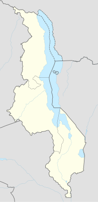
モジュール:Location map/data/Malawi
| 名称 | マラウイ | |||
|---|---|---|---|---|
| 境界の経緯 | ||||
| -9.1 | ||||
| 32.4 | ←↕→ | 36.4 | ||
| -17.3 | ||||
| 地図の中心 | 南緯13度12分 東経34度24分 / 南緯13.2度 東経34.4度 | |||
| 画像 | Malawi adm location map.svg
| |||

| ||||
| 画像1 | Malawi relief location map.jpg
| |||

| ||||

モジュール:Location map/data/Malawiはマラウイの正距円筒図法地図でオーバーレイのマーカー・ラベルを表示するのに使用する地点図のLuaモジュールです。マーカーは既定値の地図や同じような地図画像において緯度と経度の座標に基いて置かれます。
使用法
次のテンプレートで"Malawi"というパラメータを使用します:
((Location map | Malawi | ...))((Location map many | Malawi | ...))((Location map+ | Malawi | ...))((Location map~ | Malawi | ...))
地図パラメータ
name = マラウイ- モジュール名は地図説明文の既定値になります
image = Malawi adm location map.svg- 既定値の地図画像で"Image:"や"File:"は指定しません。
image1 = Malawi relief location map.jpg- 代替地図画像で、通常は地形図をreliefかAlternativeMapというパラメータで指定して表示します。
top = -9.1
bottom = -17.3- 地図最南端の緯度を十進角で表記します。
left = 32.4- 地図最西端の経度を十進角で表記します。
right = 36.4- 地図最東端の経度を十進角で表記します。
代替地図
image1 (Malawi relief location map.jpg)で定義された地図は((Location map))、((Location map many))、((Location map+))といったテンプレートの「relief」か「AlternativeMap」のパラメータを使って表示できます。
これら2つのパラメータは以下の使用例で示しています。さらなる使用例は次のテンプレートにあります。:
精度
経度: この地図は西から東まで4度です。
- 画像の幅が200ピクセルの場合は1ピクセルにつき0.02度です。
- 画像の幅が1000ピクセルの場合は1ピクセルにつき0.004度です。
緯度: この地図は北から南まで8.2度です。
- 画像の縦の長さが200ピクセルの場合は1ピクセルにつき0.041度です。
- 画像の縦の長さが1000ピクセルの場合は1ピクセルにつき0.0082度です。== Location mapテンプレート使用例 ==
Location map, using default map (image)
((Location map | Malawi
| width   = 150
| lat_deg = -13.983
| lon_deg = 33.783
| label   = Lilongwe
))
Location map many, using relief map (image1)
((Location map many | Malawi
| relief   = yes
| width    = 150
| caption  = Two locations in Malawi
| lat1_deg = -13.983
| lon1_deg = 33.783
| label1   = Lilongwe
| lat2_deg = -9.933
| lon2_deg = 33.933
| label2   = Karonga
))
Location map+, using AlternativeMap
((Location map+ | Malawi
| AlternativeMap = Malawi location map Topographic.png
| width   = 150
| caption = Two locations in Malawi
| places  =
  ((Location map~ | Malawi
  | lat_deg = -13.983
  | lon_deg = 33.783
  | label   = Lilongwe
  ))
  ((Location map~ | Malawi
  | lat_deg = -9.933
  | lon_deg = 33.933
  | label   = Karonga
  ))
))
関連項目
Location mapテンプレート
- Template:Location map - 緯度と経度を使って1つのマークとラベルを表示します。
- Template:Location map many - 9つまでのマークとラベルを表示します。
- Template:Location map+ - 無制限にマークとラベルを表示できます。
Text is available under the CC BY-SA 4.0 license; additional terms may apply.
Images, videos and audio are available under their respective licenses.


