ファイル:Aegean Sea map bathymetry-fr.jpg
このプレビューのサイズ: 493 × 600 ピクセル。 その他の解像度: 197 × 240 ピクセル | 395 × 480 ピクセル | 631 × 768 ピクセル | 842 × 1,024 ピクセル | 1,684 × 2,048 ピクセル | 3,744 × 4,554 ピクセル。
元のファイル (3,744 × 4,554 ピクセル、ファイルサイズ: 4.22メガバイト、MIME タイプ: image/jpeg)
ウィキメディア・コモンズのファイルページにある説明を、以下に表示します。
|
概要
| カメラの位置 | | 以下のサービスでこの位置を確認する: オープンストリートマップ |
|---|
| 解説 |
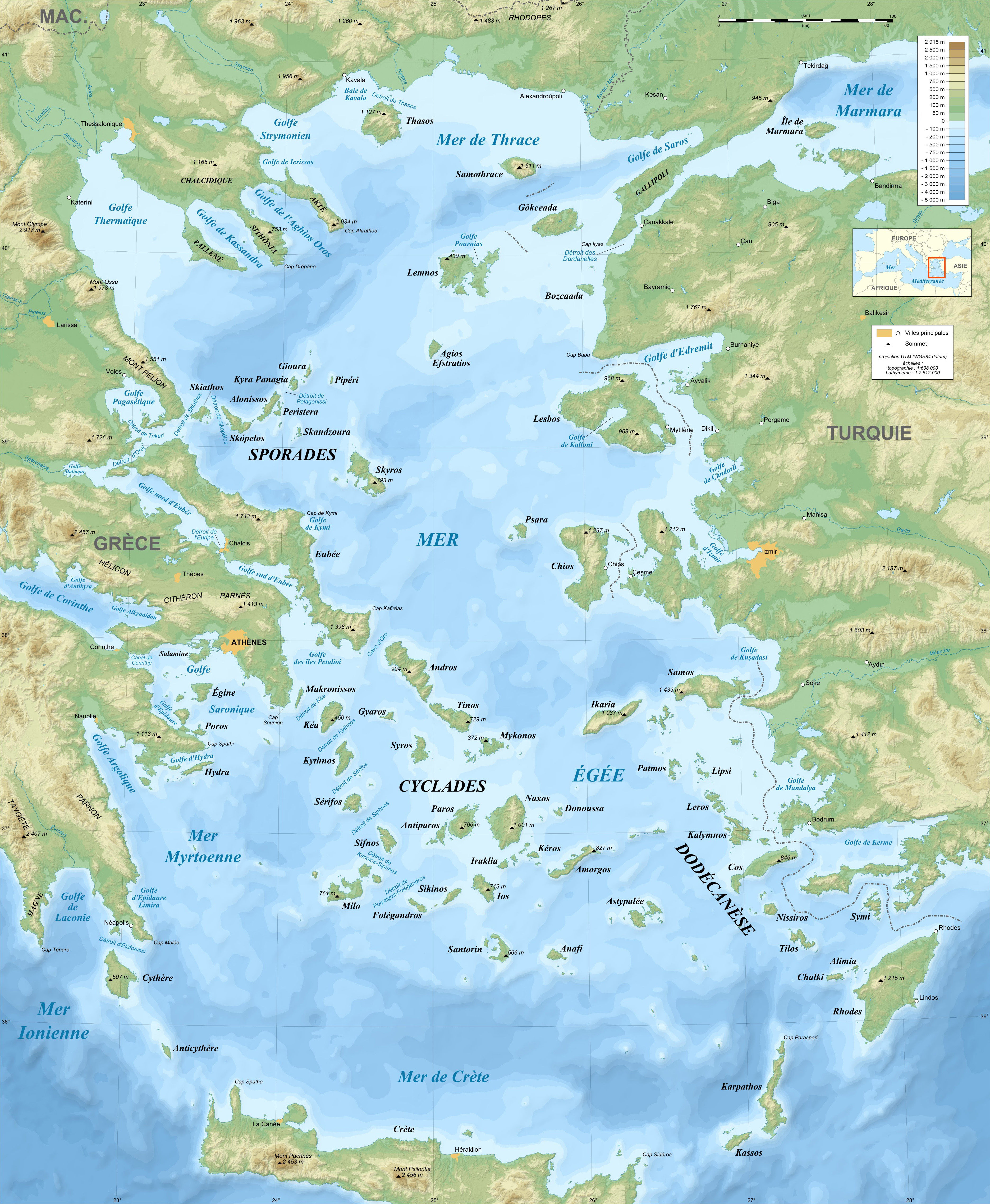
Français : Carte bathymétrique en français de la Mer Égée, Mer Méditerranée.
|
||
| 日付 | November 2007 (modified September 2008) | ||
| 原典 |
Own work ;
|
||
| 作者 | Eric Gaba (Sting - fr:Sting) | ||
| 許可 (ファイルの再利用) |
|
||
| その他のバージョン |
[]
Same map but full SVG and without relief and bathymetry:
|


ライセンス
この作品の著作権者である私は、この作品を以下のライセンスで提供します。

|
この文書は、フリーソフトウェア財団発行のGNUフリー文書利用許諾書 (GNU Free Documentation License) 1.2またはそれ以降のバージョンの規約に基づき、複製や再配布、改変が許可されます。不可変更部分、表紙、背表紙はありません。このライセンスの複製は、GNUフリー文書利用許諾書という章に含まれています。 |
This file is licensed under the Creative Commons Attribution-Share Alike Attribution-Share Alike 4.0 International, 3.0 Unported, 2.5 Generic, 2.0 Generic and 1.0 Generic license.
- あなたは以下の条件に従う場合に限り、自由に
- 共有 – 本作品を複製、頒布、展示、実演できます。
- 再構成 – 二次的著作物を作成できます。
- あなたの従うべき条件は以下の通りです。
- 表示 – あなたは適切なクレジットを表示し、ライセンスへのリンクを提供し、変更があったらその旨を示さなければなりません。これらは合理的であればどのような方法で行っても構いませんが、許諾者があなたやあなたの利用行為を支持していると示唆するような方法は除きます。
- 継承 – もしあなたがこの作品をリミックスしたり、改変したり、加工した場合には、あなたはあなたの貢献部分を元の作品とこれと同一または互換性があるライセンスの下に頒布しなければなりません。
あなたは上記のライセンスから、どれか一つ以上を選択できます。
ファイルの履歴
過去の版のファイルを表示するには、その版の日時をクリックしてください。
| 日付と時刻 | サムネイル | 寸法 | 利用者 | コメント | |
|---|---|---|---|---|---|
| 現在の版 | 2010年7月17日 (土) 21:52 | | 3,744 × 4,554 (4.22メガバイト) | Sting | Color profile |
| 2010年6月15日 (火) 19:10 |  | 3,744 × 4,554 (5.36メガバイト) | Ras67 | cropped | |
| 2009年2月12日 (木) 19:35 |  | 3,750 × 4,560 (2.74メガバイト) | Sting | == Summary == ((Location|38|00|00|N|25|00|00|E|scale:3000000)) <br/> ((Information |Description=((en|Bathymetric map in French of the Aegean Sea, Mediterranean Sea.)) ((fr|Carte bathymétrique en français de la [[:Category:Aegean |
ファイルの使用状況
以下の 35 ページがこのファイルを使用しています:
グローバルなファイル使用状況
以下に挙げる他のウィキがこの画像を使っています:
- an.wikipedia.org での使用状況
- bg.wikipedia.org での使用状況
- bs.wikipedia.org での使用状況
- cs.wikipedia.org での使用状況
- de.wikipedia.org での使用状況
- en.wikiversity.org での使用状況
- eo.wikipedia.org での使用状況
- es.wikipedia.org での使用状況
- fr.wikipedia.org での使用状況
- fr.wiktionary.org での使用状況
- gl.wikipedia.org での使用状況
- hyw.wikipedia.org での使用状況
- id.wikibooks.org での使用状況
- ilo.wikipedia.org での使用状況
- incubator.wikimedia.org での使用状況
- ko.wikipedia.org での使用状況
- lv.wikipedia.org での使用状況
- mk.wikipedia.org での使用状況
- ml.wikipedia.org での使用状況
- nl.wikipedia.org での使用状況
- pa.wikipedia.org での使用状況
- pl.wikipedia.org での使用状況
- pl.wiktionary.org での使用状況
- pt.wikipedia.org での使用状況
- ro.wikipedia.org での使用状況
- sh.wikipedia.org での使用状況
- sl.wikipedia.org での使用状況
- so.wikipedia.org での使用状況
- sr.wikipedia.org での使用状況
このファイルのグローバル使用状況を表示する。
メタデータ
Text is available under the CC BY-SA 4.0 license; additional terms may apply.
Images, videos and audio are available under their respective licenses.
Cover photo is available under {{::mainImage.info.license.name || 'Unknown'}} license.
Cover photo is available under {{::mainImage.info.license.name || 'Unknown'}} license.
Credit:
(see original file).
