For faster navigation, this Iframe is preloading the Wikiwand page for タルシス三山.

タルシス三山

タルシス三山
Tharsis Montes
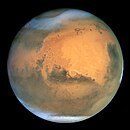
地形性の雲が火山の山頂付近に見られるタルシス地域
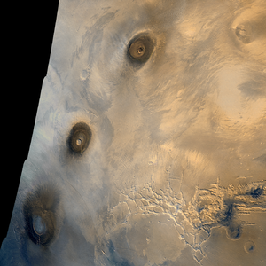
タルシス三山。北から順にアスクレウス山パヴォニス山アルシア山
種類 山脈
天体 火星 火星
場所 タルシス
座標 北緯1度34分 西経112度35分 / 北緯1.57度 西経112.58度 / 1.57; -112.58座標: 北緯1度34分 西経112度35分 / 北緯1.57度 西経112.58度 / 1.57; -112.58
標高 アスクレウス山 (18.2 km)
発見者 マリナー9号
名の由来 聖書タルシシュ

タルシス三山: Tharsis Montes)は、火星タルシス地域にある3つの巨大な楯状火山。三山とは北から南に順に、アスクレウス山パヴォニス山アルシア山である。

地形

[編集]
タルシス三山周辺地域の標高図。特徴的な三山の他、左上にはオリンポス山が、右下にはマリネリス峡谷の西側が記されている。

タルシス三山はいずれも巨大な火山であり、直径もパヴォニス山の375 km (233 mi) からアルシア山の475 km (295 mi) まで極めて大きい[1]。アスクレウス山は三山の中で最も高い山で、標高は18 km (59,000 ft) 以上に達し[2]、麓からの高さでも15 km (49,000 ft) 以上となる。地球で最大の火山はハワイ島マウナ・ロア山であるが、直径は120 km (75 mi) 程であり、麓(海底)からの高さも9 km (30,000 ft) に留まる[3]

タルシス三山は火星の赤道近くの火山平原であるタルシス地域に位置している。タルシス地域は数千kmの幅があり、標高も惑星の平均標高より10 km (33,000 ft) 近く高い。タルシス地域の端の、タルシス三山から北西1,200 km (750 mi) の位置にあるオリンポス山は、太陽系で最も高い山である。

火星地図

[編集]
Map of Marsen:Acheron Fossaeアキダリア平原アルバ・パテラアマゾニス平原en:Aonia Planitiaen:Arabia Terraアルカディア平原en:Argentea Planumen:Argyre Planitiaen:Chryse Planitiaen:Claritas Fossae火星の人面岩en:Daedalia Planumエリシウム山エリシウム平原ゲールクレーターen:Hadriaca Pateraen:Hellas Montesヘラス平原en:Hesperia PlanumHolden crateren:Icaria Planumen:Isidis PlanitiaジェゼロクレーターLomonosov crateren:Lucus Planumen:Lycus SulciLyot crateren:Lunae PlanumMalea PlanumMaraldi crateren:Mareotis FossaeMareotis Tempeen:Margaritifer TerraMie craterMilankovič crateren:Nepenthes Mensaeen:Nereidum Montesen:Nilosyrtis Mensaeen:Noachis Terraen:Olympica Fossaeオリンポス山アウストラレ高原en:Promethei Terraen:Protonilus Mensaeen:SirenumSisyphi Planumen:Solis Planumen:Syria Planumen:Tantalus Fossaeen:Tempe Terraen:Terra Cimmeriaen:Terra Sabaeaen:Terra Sirenumタルシス三山en:Tractus Catenaen:Tyrrhen Terraユリシーズ・トーラスen:Uranius Pateraユートピア平原マリネリス峡谷en:Vastitas Borealisen:Xanthe Terra
The image above contains clickable links火星(記念碑の場所)の世界的な地形のインタラクティブな画像地図。画像の上にマウスを置くと、60を超える著名な地理的特徴の名前が表示され、クリックするとリンクする。ベースマップの色は、NASAのマーズグローバルサーベイヤーのマーズオービターレーザー高度計からのデータに基づいて、相対的な標高を示す。白色と茶色は最も標高が高い。(+12 to +8 km); ピンクと赤が続く。(+8 to +3 km)。黄色は0 km。緑と青は標高が低い(down to −8 km)。軸は緯度と経度。極域が注目される
(   名称  堆積物  ロスト )
Beagle 2
Curiosity
Deep Space 2
InSight
Mars 2
Mars 3
Mars 6
Mars Polar Lander
Opportunity
Pereverance
Phoenix
Schiaparelli EDM lander
Pathfinder
Spirit
Viking 1
Viking 2


画像

[編集]

脚注

[編集]
  1. ^ "タルシス三山". Gazetteer of Planetary Nomenclature. USGS Astrogeology Research Program.
  2. ^ Plescia, J.B. (2004). Morphometric Properties of Martian Volcanoes. J. Geophys. Res. 109(E03003), Table 1.
  3. ^ Carr, M.H. (2006). The Surface of Mars; Cambridge University Press: Cambridge, UK, p. 46.

関連項目

[編集]
{{bottomLinkPreText}} {{bottomLinkText}}
タルシス三山
Listen to this article

This browser is not supported by Wikiwand :(
Wikiwand requires a browser with modern capabilities in order to provide you with the best reading experience.
Please download and use one of the following browsers:

This article was just edited, click to reload
This article has been deleted on Wikipedia (Why?)

Back to homepage

Please click Add in the dialog above
Please click Allow in the top-left corner,
then click Install Now in the dialog
Please click Open in the download dialog,
then click Install
Please click the "Downloads" icon in the Safari toolbar, open the first download in the list,
then click Install
{{::$root.activation.text}}

Install Wikiwand

Install on Chrome Install on Firefox
Don't forget to rate us

Tell your friends about Wikiwand!

Gmail Facebook Twitter Link

Enjoying Wikiwand?

Tell your friends and spread the love:
Share on Gmail Share on Facebook Share on Twitter Share on Buffer

Our magic isn't perfect

You can help our automatic cover photo selection by reporting an unsuitable photo.

This photo is visually disturbing This photo is not a good choice

Thank you for helping!


Your input will affect cover photo selection, along with input from other users.

X

Get ready for Wikiwand 2.0 🎉! the new version arrives on September 1st! Don't want to wait?