アウストラレ高原
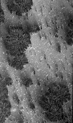
 マーズ・グローバル・サーベイヤーが撮影したアウストラレ高原。 | |
| 種類 | 高原 |
|---|---|
| 天体 |
|
| 座標 | 南緯83度54分 東経160度00分 / 南緯83.9度 東経160.0度座標: 南緯83度54分 東経160度00分 / 南緯83.9度 東経160.0度 |
| 名の由来 | ラテン語の南の平原 |
アウストラレ高原(アウストラレこうげん、ラテン語: Planum Australe)は、火星の南極に位置する高原である。名称はラテン語の南の平原に由来する。高原は南緯75度付近から南へ広がっており、中心は南緯83度54分 東経160度00分 / 南緯83.9度 東経160.0度付近に位置する。
この地域の地質学的調査は、かつてアメリカ航空宇宙局 (NASA) のマーズ・ポーラー・ランダーにて探査が試みられたものの、同機は火星の大気圏への突入時に通信が失われたため、失敗に終わっている。
2018年7月、欧州宇宙機関 (ESA) のマーズ・エクスプレスのMARSISレーダーによる観測結果から、この地域の氷床の地下1.5 kmの深さに、幅20 kmに渡る氷底湖が存在するとの研究結果が報告された。これは火星で発見された、初めての安定した液体の水である[1][2][3][4]。
氷冠
[編集]
アウストラレ高原は部分的に、水の氷とCO2の氷(ドライアイス)からなる厚さ3 kmの永久の極冠に覆われている。火星の冬になると、季節性の氷冠がこれらに加わり、その範囲は南緯60度付近まで広がる。これら季節性の氷冠は厚さは1 mほどである[5]。 氷冠の広さは、地域的な気候変動により縮小している可能性がある[6]。 惑星全体の気温が上昇しているという説も主張されているが、探査機とマイクロ波によるデータでは火星全体の気温は安定しており[7][8]、むしろ寒冷化の可能性を示している[9][10][11]。
1966年、LeightonとMurrayは火星の両極には大量のCO2が氷の形で蓄積されているとの仮説を発表した。しかし今日では、極冠の大部分は水の氷で構成されていると考えられている。両極の氷冠のうち、季節性の薄い層はCO2とみられており、南極ではさらにその下に8~10 mの永久のCO2層があり、さらにその下に分厚い水の氷の層が広がっている。CO2の氷は水の氷と比べて脆く、CO2では厚さ3 kmもの氷冠を長期に渡り安定して存在させることはできないと分析されている[12]。 NASAのマーズ・リコネッサンス・オービターのSHARAD氷貫通レーダーによる最新の研究では、アウストラレ高原の地下に存在するCO2の氷の量は、現在の火星大気の約80%に相当すると見積もられている[13]。
ESAのマーズ・エクスプレスのデータによれば、氷冠は主に3つの領域から構成されている。1つ目は最も反射率が高い領域で、この領域はCO2の氷が85%、水の氷が15%を占めている。2つ目は氷冠から周辺の平地への斜面を形成している領域で、ほぼ水の氷で形成されている。3つ目は氷冠を囲む永久凍土の領域で、斜面から数十 kmに渡って広がっている[14]。
永久の氷冠の中心は、南緯90度の南極点ではなく、そこから北に約150 km離れた地点に位置している。火星の西半球にはヘラス平原とアルギル平原という2つの大きな衝突盆地(クレーター)が存在しており、これにより氷冠の上に移動しない低気圧が作り出される。その結果、氷冠には白い雪が降り積もり、アルベドが高くなっている。これは、雪の少ない南極の東側が黒い氷で覆われているのとは対照的である[15]。
地形
[編集]

アウストラレ高原には、Australe LingulaとPromethei Lingulaと呼ばれる2つの小さな領域が存在する。またプロメセイ・カズマ、ウルティマム・カズマ、カズマ・アウストラレ、アウストラレ・スルクスと名付けられた谷が存在する。これらの谷は滑降風により形成されたと考えられている[16]。 また、アウストラレ高原にはクレーターも点在し、それらの中で最大のものはマクマードクレーターである。
火星の間欠泉
[編集]季節により凍結と解凍が繰り返される結果、氷冠の表層1 mのCO2の氷の層には、太陽光によりクモの巣のように放射状に抉られた地形が形成される[17]。 昇華したCO2(おそらく水も)は氷の内側で圧力を増し、間欠泉のように暗い砂か泥の混じった冷たい液体を噴き上げる[18][19][20][21]。 宇宙からの観測によれば、このプロセスは数日から数週間、数か月という地質学的には極めて短い時間で起こっており、ほとんど地質学的な変化がない火星では極めて珍しい。火星の間欠泉の調査に向けて、Mars Geyser Hopperという着陸機が提案されている[22][23]。
氷底湖
[編集]
ESAのマーズ・エクスプレスのMARSISレーダーによる観測結果から、アウストラレ高原の南緯81° 東経193° / 南緯81度 東経193度付近の氷床の地下1.5 kmの深さに、幅20 kmに渡って液体の水の湖(氷底湖)が存在するとの研究結果が報告されている。氷床底部は約-68 ℃と極めて低温ながら、水には大量の塩類が溶解しているために凝固点降下が起こり、液体の状態を保っているのではないかとも言われている。しかし、波長の異なるマーズ・リコネッサンス・オービターのSHARADレーダーでは発見できなかったことから、水で飽和した堆積物(泥)の形をとっている可能性も指摘されている[1][24]。
火星地図
[編集]
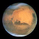
 火星(記念碑の場所)の世界的な地形のインタラクティブな画像地図。画像の上にマウスを置くと、60を超える著名な地理的特徴の名前が表示され、クリックするとリンクする。ベースマップの色は、NASAのマーズグローバルサーベイヤーのマーズオービターレーザー高度計からのデータに基づいて、相対的な標高を示す。白色と茶色は最も標高が高い。(+12 to +8 km); ピンクと赤が続く。(+8 to +3 km)。黄色は0 km。緑と青は標高が低い(down to −8 km)。軸は緯度と経度。極域が注目される
参考文献
[編集]- ^ a b Orosei, R. et al. (25 July 2018). “Radar evidence of subglacial liquid water on Mars”. Science. doi:10.1126/science.aar7268 25 July 2018閲覧。.
- ^ Chang, Kenneth; Overbye, Dennis (25 July 2018). “A Watery Lake Is Detected on Mars, Raising the Potential for Alien Life - The discovery suggests that watery conditions beneath the icy southern polar cap may have provided one of the critical building blocks for life on the red planet.”. ニューヨーク・タイムズ 25 July 2018閲覧。
- ^ “Huge reservoir of liquid water detected under the surface of Mars”. アメリカ科学振興協会 (25 July 2018). 25 July 2018閲覧。
- ^ “Liquid water 'lake' revealed on Mars”. BBCニュース (25 July 2018). 25 July 2018閲覧。
- ^ Phillips, Tony. “Mars is Melting”. Science @ NASA. 2007年2月24日時点のオリジナルよりアーカイブ。2006年10月20日閲覧。
- ^ Sigurdsson, Steinn. “Global warming on Mars?”. RealClimate.org. 2006年10月20日閲覧。
- ^ Wilson, R.; Richardson, M. (2000). “The Martian Atmosphere During the Viking I Mission, I: Infrared Measurements of Atmospheric Temperatures Revisited”. Icarus 145: 555–579. Bibcode: 2000Icar..145..555W. doi:10.1006/icar.2000.6378.
- ^ Liu, J.; Richardson, M. (August 2003). “An assessment of the global, seasonal, and interannual spacecraft record of Martian climate in the thermal infrared”. Journal of Geophysical Research 108 (8). Bibcode: 2003JGRE..108.5089L. doi:10.1029/2002je001921.
- ^ Clancy, R.. “An intercomparison of ground-based millimeter, MGS TES, and Viking atmospheric temperature measurements: Seasonal and interannual variability of temperatures and dust loading in the global Mars atmosphere”. Journal of Geophysical Research 105 (4): 9553–9571. Bibcode: 2000JGR...105.9553C. doi:10.1029/1999je001089.
- ^ Bell, J.. “Mars Reconnaissance Orbiter Mars Color Imager (MARCI): Instrument Description, Calibration, and Performance”. Journal of Geophysical Research 114 (8). Bibcode: 2009JGRE..114.8S92B. doi:10.1029/2008je003315.
- ^ Bandfield, J. (2013). “Radiometric Comparison of Mars Climate Sounder and Thermal Emission Spectrometer Measurements”. Icarus 225: 28–39. Bibcode: 2013Icar..225...28B. doi:10.1016/j.icarus.2013.03.007.
- ^ Byrne, Shane; Ingersoll, AP (14 February 2003). “A Sublimation Model for Martian South Polar Ice Features”. Science 299 (5609): 1051–1053. Bibcode: 2003Sci...299.1051B. doi:10.1126/science.1080148. PMID 12586939.
- ^ Philips, R. J. et. al (2011). “Onset and migration of spiral troughs on Mars revealed by orbital radar”. Science 332 (13): 838–841. Bibcode: 2011Sci...332..838P. doi:10.1126/science.1203091.
- ^ “Water at Martian south pole”. 欧州宇宙機関. 2006年10月22日閲覧。
- ^ “Mars' South Pole mystery”. Spaceflight Now. 2006年10月26日閲覧。
- ^ Kolb, Eric J.; Tanaka, Kenneth L. (2006). “Accumulation and erosion of south polar layered deposits in the Promethei Lingula region, Planum Australe, Mars”. The Mars Journal (Mars Informatics Inc.) 2: 1–9. Bibcode: 2006IJMSE...2....1K. doi:10.1555/mars.2006.0001.
- ^ Mangold, N. 2011. Ice sublimation as a geomorphic process: A planetary perspective. Geomorphology. 126:1-17.
- ^ “NASA Findings Suggest Jets Bursting From Martian Ice Cap”. Jet Propulsion Laboratory (NASA). (August 16, 2006) 2009年8月11日閲覧。
- ^ Kieffer, H. H. (2000). ANNUAL PUNCTUATED CO2 SLAB-ICE AND JETS ON MARS (PDF). Mars Polar Science 2000. 2009年9月6日閲覧。
- ^ Portyankina, G., ed. (2006). SIMULATIONS OF GEYSER-TYPE ERUPTIONS IN CRYPTIC REGION OF MARTIAN SOUTH (PDF). Fourth Mars Polar Science Conference. 2009年8月11日閲覧。
- ^ Kieffer, Hugh H.; Christensen, Philip R.; Titus, Timothy N. (30 May 2006). “CO2 jets formed by sublimation beneath translucent slab ice in Mars' seasonal south polar ice cap”. Nature 442 (7104): 793–796. Bibcode: 2006Natur.442..793K. doi:10.1038/nature04945. PMID 16915284 2009年9月2日閲覧。.
- ^ “Design Study for a Mars Geyser Hopper”. NASA (9 January 2012). 2012年7月1日閲覧。
- ^ Landis, Geoffrey A.; Oleson, Steven J.; McGuire, Melissa (9 January 2012). Design Study for a Mars Geyser Hopper (PDF). 50th AIAA Aerospace Sciences Conference. Glenn Research Center, NASA. AIAA-2012-0631. 2012年7月1日閲覧。
- ^ “【解説】火星の地下に湖を発見、太古の海の痕跡?”. ナショナルジオグラフィック (2018年7月27日). 2018年7月29日閲覧。
関連項目
[編集]- 火星の生命
- 火星の地形一覧
- 火星の極冠
- 火星の北極冠(Planum Boreum)、カズマ・ボレアレ地溝
- 火星の二酸化炭素噴出 ‐ 春になると火星の地下の揮発性物質(ドライアイスからの二酸化炭素など)の噴出が起きる。
- スイスチーズ状の地形
| 探査 |
| |||||||||||||||
|---|---|---|---|---|---|---|---|---|---|---|---|---|---|---|---|---|
| 地理 |
| |||||||||||||||
| 衛星 | ||||||||||||||||
| 太陽面通過 |
| |||||||||||||||
| 小惑星 | ||||||||||||||||
| 歴史 | ||||||||||||||||
| その他 | ||||||||||||||||
Text is available under the CC BY-SA 4.0 license; additional terms may apply.
Images, videos and audio are available under their respective licenses.

