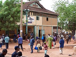
キタ (マリ共和国)
| キタ Kita | |
|---|---|
 2017年撮影 | |
| 位置 | |
 キタ・コミューンの地図 | |
| 位置 | |
| 座標 : 北緯13度2分20秒 西経9度29分15秒 / 北緯13.03889度 西経9.48750度 | |
| 行政 | |
| 国 | |
| 州 | キタ州 |
| 圏 | キタ圏 |
| コミューン | キタ |
| 地理 | |
| 面積 | |
| コミューン域 | 27.9[1] km2 |
| 標高 | 330 m |
| 人口 | |
| 人口 | (2009年現在) |
| コミューン域 | 49,043人 |
| 人口密度 | 1,758人/km2 |
| 備考 | [1] |
| その他 | |
| 等時帯 | グリニッジ標準時 (UTC+0) |
キタ(フランス語: Kita)は、マリ共和国キタ州キタ圏の都市型コミューン。同州、同圏の首府でもある。人口は49,043人(2009年国勢調査[1])。洞窟や岩絵で知られるキタ山の東斜面に位置する。
毎年開催されるローマ・カトリック教会の巡礼、周辺で栽培された綿花と落花生の加工センターとして機能している。町はダカール・ニジェール鉄道の沿線にあり、バマコとカイ間の最大の交通ハブである。
名称
[編集]キタは時代によって様々な名前で呼ばれた。初期の名前のひとつはGuénou Kourouである[2]。またSediousabaは村全体あるいは中心部を指す言葉として使われたという[3]。
歴史
[編集]キタは主要な2つの集落が合併してできたと考えられているが、どちらが先に誕生したのかは議論がある。
集落のひとつはガーナ帝国のOuagadou出身のトゥンカラ商人が設立したと考えられていた。この集落の首長Diouna Tounkaraは、「3本のシアの木」を意味するSediousabaと名付けた[3] 。もう一方の集落はギニア出身の商人Siema Toloba Kamaraが13世紀に設立したFataliで、後に2つの集落は合併しLinguékotoとなった[3]。
植民地時代の1958年、キタ・準コミューン(市長は植民地政府が任命)が創設された。1966年3月2日、準コミューンから独立したコミューンに昇格した[4]。
1990年代に綿花産業を中心に成長したが、その後は停滞している。
気候
[編集]ケッペンの気候区分ではサバナ気候に区分されている。11月から5月下旬は乾季で、乾燥しており気温も高い。5月下旬から10月は雨季で、総降水量は約900ミリメートルに達し蒸し暑くなる。
| キタ気候観測所(標高334m) 1991年-2020年 平均値の気候 | |||||||||||||
|---|---|---|---|---|---|---|---|---|---|---|---|---|---|
| 月 | 1月 | 2月 | 3月 | 4月 | 5月 | 6月 | 7月 | 8月 | 9月 | 10月 | 11月 | 12月 | 年 |
| 平均最高気温 °C (°F) | 33.6 (92.5) |
36.0 (96.8) |
39.1 (102.4) |
40.6 (105.1) |
39.3 (102.7) |
35.8 (96.4) |
32.1 (89.8) |
30.1 (86.2) |
32.1 (89.8) |
34.6 (94.3) |
35.8 (96.4) |
34.2 (93.6) |
35.2 (95.4) |
| 平均最低気温 °C (°F) | 19.5 (67.1) |
22.1 (71.8) |
25.4 (77.7) |
28.0 (82.4) |
27.5 (81.5) |
25.3 (77.5) |
23.5 (74.3) |
22.9 (73.2) |
22.9 (73.2) |
22.8 (73) |
20.2 (68.4) |
19.1 (66.4) |
23.1 (73.6) |
| 雨量 mm (inch) | 0.6 (0.024) |
6.2 (0.244) |
7.6 (0.299) |
9.8 (0.386) |
39.6 (1.559) |
121.9 (4.799) |
200.5 (7.894) |
254.5 (10.02) |
195.2 (7.685) |
60.1 (2.366) |
2.1 (0.083) |
0.4 (0.016) |
930.0 (36.614) |
| 平均降雨日数 (≥1.0 mm) | 0.16 | 0.05 | 0.29 | 1.17 | 4.43 | 9.23 | 13.19 | 15.55 | 13.59 | 5.73 | 0.37 | 0.15 | 64.24 |
| 平均月間日照時間 | 249.7 | 250.6 | 290.4 | 269.5 | 262.3 | 243.4 | 202.9 | 191.0 | 217.0 | 268.2 | 254.3 | 254.4 | 2,931.7 |
| 出典:Meteo Climat[5] | |||||||||||||
出身人物
[編集]- セク・コイタ - サッカー選手
- Bako Dagnon - 女性のグリオ
- Cheick Hamala Diabaté - グリオ、音楽家
- Mamadou Diabaté - 音楽家
- Massa Makan Diabaté - 歴史家、作家。キタをモデルとした『Le lieutenant de Kouta』『Le coiffeur de Kouta 』『Le boucher de Kouta』の三部作を執筆
- Kandia Kouyaté - 女性のグリオ
- Djelimady Tounkara - 音楽家
出典
[編集]- ^ a b c “KITA”. Citypopulation (2017年7月26日). 2024年5月9日閲覧。
- ^ KEITA, MADIBA (2019年7月22日). “Le saviez-vous ?: LES MILLE ET UN MYSTÈRES DE KITA”. ESSOR. 2024年5月10日閲覧。
- ^ a b c TELLIER, G (1902) (フランス語). Autour de Kita - Etude Soudanaise. Imprimerie et Librairie Henri Charles-Lavauzelle. pp. 33
- ^ “Recherche sur l’Historique de la Décentralisation au Mali” (2004年3月1日). 2009年8月2日時点のオリジナルよりアーカイブ。2024年4月30日閲覧。
- ^ “Climate Normals 1991-2020”. Meteo Climat. 2021年4月11日閲覧。
外部リンク
[編集]- (フランス語) Plan de Sécurité Alimentaire Commune Urbaine de Kita 2007-2011, Commissariat à la Sécurité Alimentaire, République du Mali, USAID-Mali, (2006), オリジナルの2012-09-17時点におけるアーカイブ。 2012年5月12日閲覧。.
Text is available under the CC BY-SA 4.0 license; additional terms may apply.
Images, videos and audio are available under their respective licenses.

