カイ (マリ)
カイ Kayi, Xaayi | |
|---|---|
|
市 | |
| Kayes | |
 カイで混雑した道を渡る男性、2006年 | |
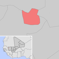
 カイ・コミューンの地図 | |
| 座標:北緯14度27分 西経11度26分 / 北緯14.450度 西経11.433度座標: 北緯14度27分 西経11度26分 / 北緯14.450度 西経11.433度 | |
| 国 |
|
| 州 | カイ州 |
| 圏 | カイ圏 |
| 建設 | 1880年代 |
| 面積 | |
| • 合計 | 12.9 km2 |
| 標高 | 33 m |
| 人口 (2009 census)[2] | |
| • 合計 | 127,368人 |
| • 密度 | 9,900人/km2 |
| 等時帯 | UTC+0 (GMT) |

カイ(仏: Kayes)は、マリ共和国のカイ州の州都[3]。カイ州カイ圏(セルクル)内に位置する。その綴りから、カタカナ表記の場合ケーズまたはカイェ、カエスと表記されることもある[4][5]。2009年の人口は12万7368人。マリ共和国の首都バマコから北西に420 km(キロメートル)離れたマリ西部に位置し、セネガル川に面する。カイ(Kayes)という地名はソニンケ語で「雨季に水没する低湿地」を意味する karré に由来する。
フランスが進出してくる前は、カイは小さな村だった。フランスの内陸部進出のためにダカール・ニジェール鉄道の建設が計画された時、この地域にセネガルとの交易の為フランスの拠点が必要となった為、1881年にカイの街が建設された。1892年にはカイはフランス領スーダンの首都となったが、やがて1904年にはより奥地にあるバマコに遷都された[6]。1919年にはバマコとともにフランス領スーダン初の自治体となった[7]。
カイはマリ国道1号線上にあり、首都バマコから国道1号で612 km、セネガル国境からは96 ㎞離れている。この国道はセネガル国内からカイまでは舗装されているが、ここからバマコまでは未舗装である[8]。カイには国際空港があり、またダカール・ニジェール鉄道が通っていて、この地方に豊富な金や鉄を輸送している。またセネガル川は増水期にはカイまで船舶の航行が可能であり[9]、これが植民地初期にカイにこの地域の首都がおかれる要因となった。
気候
[編集]カイは西アフリカモンスーンの影響を受ける6月から10月にかけて降水があり、最も暑い月は8月である。残りの7ヶ月間にはほとんど降雨はない。年間降水量は約650 mmである[10]。カイは乾季には非常に高温になる事で知られており、鉄分の多い山に周囲を囲まれている事もあり「アフリカの圧力鍋」との呼び名も有る程である。カイはアフリカでも最も暑い街の一つとされている。一日当たりの平均最高気温は35℃、雨季が到来する直前の4月から5月にかけては46℃にも達する[11]。
| Kayes (1950–2000)の気候 | |||||||||||||
|---|---|---|---|---|---|---|---|---|---|---|---|---|---|
| 月 | 1月 | 2月 | 3月 | 4月 | 5月 | 6月 | 7月 | 8月 | 9月 | 10月 | 11月 | 12月 | 年 |
| 平均最高気温 °C (°F) | 33.6 (92.5) |
36.6 (97.9) |
39.4 (102.9) |
41.7 (107.1) |
41.9 (107.4) |
38.2 (100.8) |
33.6 (92.5) |
32.0 (89.6) |
33.1 (91.6) |
36.1 (97) |
36.7 (98.1) |
33.5 (92.3) |
36.37 (97.47) |
| 平均最低気温 °C (°F) | 16.9 (62.4) |
19.3 (66.7) |
22.2 (72) |
25.5 (77.9) |
28.4 (83.1) |
26.6 (79.9) |
24.2 (75.6) |
23.3 (73.9) |
23.2 (73.8) |
23.0 (73.4) |
20.0 (68) |
17.2 (63) |
22.48 (72.47) |
| 雨量 mm (inch) | 0.0 (0) |
0.4 (0.016) |
0.1 (0.004) |
0.6 (0.024) |
12.0 (0.472) |
82.6 (3.252) |
155.2 (6.11) |
215.9 (8.5) |
140.9 (5.547) |
41.2 (1.622) |
2.7 (0.106) |
1.1 (0.043) |
652.7 (25.696) |
| 平均降雨日数 (≥0.1 mm) | 0.0 | 0.0 | 0.1 | 0.1 | 2.8 | 7.8 | 12.3 | 14.8 | 11.4 | 4.0 | 0.1 | 0.0 | 53.4 |
| 平均月間日照時間 | 263.5 | 250.0 | 282.1 | 285.0 | 279.0 | 215.0 | 211.8 | 223.2 | 240.0 | 263.5 | 264.0 | 260.6 | 3,037.7 |
| 出典1:World Meteorological Organization[12] | |||||||||||||
| 出典2:NOAA (sun 1961–1990)[13] | |||||||||||||
脚注
[編集]出典
[編集]- ^ “KAYES”. Citypopulation (2017年7月26日). 2024年5月27日閲覧。
- ^ (French) Resultats Provisoires RGPH 2009 (Région de Kayes), République de Mali: Institut National de la Statistique, オリジナルの2012-09-19時点におけるアーカイブ。.
- ^ “Regions of Mali”. Statoids (2016年1月25日). 2024年5月27日閲覧。
- ^ 藤井宏志. "ケーズ". 日本大百科全書. コトバンクより2023年12月21日閲覧。
- ^ "カイェ". デジタル大辞泉. コトバンクより2023年12月21日閲覧。
- ^ 竹沢 2015, p. 158.
- ^ 竹沢 2015, p. 274.
- ^ 竹沢 2015, p. 19.
- ^ 竹沢 2015, p. 18.
- ^ Weather Information for Kayes, World Weather Information Service 2012年5月15日閲覧。
- ^ “Kayes, Mali”. World Weather Information Service. 2017年9月6日閲覧。
- ^ “World Weather Information Service – Kayes”. World Meteorological Organization. 2015年10月12日閲覧。
- ^ “Kayes Climate Normals 1961–1990”. National Oceanic and Atmospheric Administration. 2015年10月12日閲覧。
参考文献
[編集]- 竹沢尚一郎 編著『マリを知るための58章』明石書店、東京〈エリア・スタディーズ〉、2015年。ISBN 9784750342528。
Text is available under the CC BY-SA 4.0 license; additional terms may apply.
Images, videos and audio are available under their respective licenses.

